Forecast for the Moab Area Mountains

Dave Garcia
Issued by Dave Garcia on
Wednesday morning, February 4, 2026

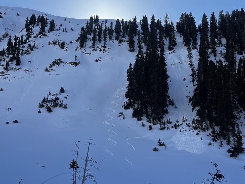
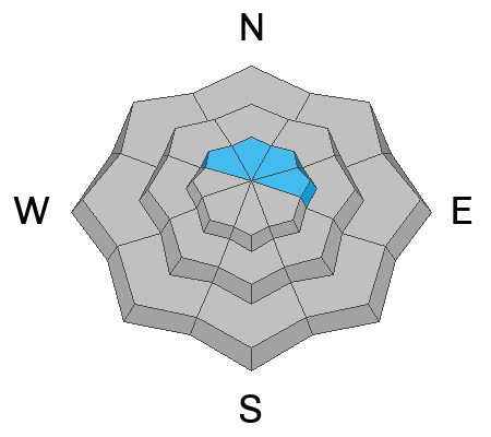
A MODERATE avalanche danger exists on steep slopes above treeline that face NW-N-NE-E. In these areas, hard slabs of wind drifted snow over ride layers of weak, sugary, faceted snow and human triggered avalanches 1-2 feet deep are possible. Avoid steep terrain with stiff, hard slabs that sound or feel hollow underneath.

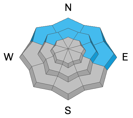
On these same aspects near treeline and below, shallow dry loose avalanches involving weak, faceted snow are possible to likely. Though not large enough to bury you, they could take you for a ride and carry you into trees or over a cliff. Manage terrain carefully.

Low
Moderate
Considerable
High
Extreme
Learn how to read the forecast here
Special Announcements

Check out this recent blog post from Forest Service UAC Director Paige Pagnucco Weak Snow: Today's Surface, Tomorrow's Avalanche Problem.

Geyser Pass Road Conditions: The road is down to the dirt down low while sections of packed snow and ice remain above. AWD with good tires recommended.

Grooming: LUNA groomed all trails on Monday.

We are looking to reschedule our Moab Backcountry 101 Class to February 20, 21 in the hopes that we will have more snow. Click here for information and registration. Moab and Monticello locals can use the discount code MOAB-LOCAL for a 10% discount.

Weather and Snow

24 Hour Snow: 0" 72 Hour Snow: 0" Season Total Snow: 44" Depth at Gold Basin: 27"

Winds on Pre-Laurel Peak: NNW 10-15 G 20 Temp: 21°F

Weather

Under clear skies, it is 21° F in Gold Basin this morning. High temperatures will be in the upper 30s° F at 10,000 feet. Skies will be clear, and winds will be light, blowing from the north-northeast. Mostly dry and unseasonably warm conditions persist through the weekend, with temperatures 10-15 degrees above normal. A pattern shift is possible early next week.

General Conditions

It is getting more difficult to find good skiing and riding. Our last storm dropped 8-10 inches of snow on January 23rd. Since then, exposed windward slopes have been scoured by strong west and northwest winds. Hard slabs of previously drifted snow are widespread above treeline on leeward aspects. South-facing slopes are showing many bare spots or are crusted over where they do hold snow.

The best skiing and riding is found on sheltered, shady aspects. On these slopes, slab distribution is isolated, and the snowpack is weak and faceted top to bottom. This makes for fun turning in “recycled” or “loud” powder. This very weak surface snow is prone to sluffing in steep, continuous terrain. Dry, loose avalanches will become more likely and grow larger in size as long as our high-and-dry weather persists.

Skier triggered dry, loose avalanche in steep terrain.

See recent observations here.

Snowpack and Weather Data

Gold Basin SNOTEL site (10,000')
SNOTEL site near Geyser Pass Winter Trailhead (9600')
Wind Station on Pre-Laurel Peak (11,400')
NWS forecast for the La Sal Mountains.
Recent Avalanches
No recent avalanches have been reported.
Avalanche Problem #1
Persistent Weak Layer
Type
Location
Likelihood
Size
Description

Human-triggered avalanches failing on persistent weak layers continue to be a concern on northerly aspects above treeline, where old, hard slabs of wind-drifted snow rest on weak, faceted snow. The primary layer of concern is a faceted layer that formed near the snow surface before the January 23rd storm. Multiple periods of strong winds have since built stiff slabs on top of this weakness, and human-triggered avalanches 1–2 feet deep remain possible. While less likely, avalanches failing on this layer could step down into deeper weak layers in the snowpack, producing a much larger and more dangerous slide.

Given these conditions, upper-elevation, wind-loaded terrain continues to warrant caution. Avoid steep slopes just below ridgelines where smooth, hard slabs of wind-drifted snow are present, especially if the snow feels hollow or sounds drum-like underfoot.

Avalanche Problem #2
Normal Caution
Type
Location
Likelihood
Size
Description

Although most other terrain has generally low danger, small, dry loose avalanches are possible if not likely on steep, shady slopes near treeline and below. The size of the slope dictates how much snow will become entrained, and if enough is accumulated, these slides can pack a punch. They won't be enough to bury you, but they could take you for a ride and carry you into trees or over a cliff. Manage terrain carefully and be aware of where you might end up. Stop at likely trigger points such as convexities or where the slope suddenly gets steeper. Stop or get off to the side if the snow starts moving. The main thing is to catch it early and let it slide without you in it.

Looking ahead, this very weak snow surface will be our next weak layer of concern once it is buried. Any significant additional loading—particularly if accompanied by wind—could increase the likelihood of large and dangerous avalanches.

Additional Information
General Announcements
This forecast is from the U.S.D.A. Forest Service, which is solely responsible for its content. This forecast describes general avalanche conditions and local variations always occur.