Forecast for the Moab Area Mountains

Eric Trenbeath
Issued by Eric Trenbeath on
Thursday morning, February 26, 2026

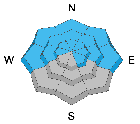
The avalanche danger is CONSIDERABLE on steep slopes near treeline and above that face west to north to east. Slopes that face north and east are of most concern. Human-triggered hard slab avalanches 2 to 4 feet deep are likely, failing on a buried persistent weak layer. These avalanches could step down and release the entire season’s snowpack.

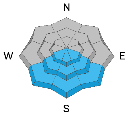
Persistent weak layers are also present below treeline on west to north to east aspects, and above treeline on southeast aspects, where the danger is MODERATE and human-triggered slab avalanches remain possible.

Overnight low temperatures barely dipped below freezing. Be on the lookout for wet-loose activity on solar aspects as the day warms up.

Low
Moderate
Considerable
High
Extreme
Learn how to read the forecast here
Special Announcements

Geyser Pass Road Conditions: The road is plowed and scraped down to the dirt in most areas.

Grooming: LUNA groomed all trails on Sunday and set classic track.

Mountain Film on Tour returns to Star Hall in Moab on Saturday, March 14. Tickets are available online and all proceeds benefit UAC Moab. Look forward to seeing you all there!

Weather and Snow

24 Hour Snow: 0" 72 Hour Snow: 0" Season Total Snow: 71" Depth at Gold Basin: 34"

Winds on Pre-Laurel Peak: NW 10-15 G20 Temp: 39°F

Weather

Overnight lows dipped to 30°F for about three hours last night and 10,000 foot temperatures are already well above freezing this morning at 39°F. Northwest flow aloft will continue to give us breezy conditions today and into tomorrow. Some mountain cloudiness this morning should give way to sunny skies with high temperatures in the mid 30's up high, and low 40's down low. A weak system is being advertised for Sunday-Monday but it doesn't look like anything to get excited about.

General Conditions

Our one week of winter is already a distant memory as wind and warm temperatures have taken their toll. Reaching a peak depth of 48 inches last Friday, the height of snow has already shrunk to 34 inches. Warm temperatures have created mashed potato conditions on low elevation northerly aspects. South facing slopes that have snow will be lightly crusted and punchy this morning but will quickly become wet and sloppy.

In spite of the spring-like surface conditions, the underlying snowpack remains loose, and faceted and the 2/11 persistent weak layer is still widespread and reactive. Ryan Huels was up yesterday and he observed poor snowpack structure and reactive stability tests on both NW and W aspects below treeline. In these areas, it remains possible to trigger soft slab avalanches on steep slopes. Near treeline and above, hard slabs of wind drifted snow 2-4 feet thick exist over these faceted weak layers, and deep and dangerous, human-triggered avalanches remain likely.

See all Moab observations here.

Snowpack and Weather Data

Wind Station on Pre-Laurel Peak (11,400')
NWS forecast for the La Sal Mountains.
Recent Avalanches
The avalanche database has recently been updated to include all observed avalanches since Friday's storm. We have seen both natural and human-triggered hard slab avalanches, and some small natural dry loose avalanches in recent days.
Avalanche Problem #1
Persistent Weak Layer
Type
Location
Likelihood
Size
Description

Poor snowpack structure remains widespread on slopes facing west to north to east. The 2/11 persistent weak layer is now buried beneath 22 inches of recent snow. On some below-treeline slopes, this new snow has formed a cohesive slab, and skiers and riders can still trigger soft slab avalanches. The danger increases with elevation, where thicker, more cohesive slabs rest above the weak layer. The greatest concern is on slopes that face north and east, where hard slabs 2 to 4 feet thick now rest above weak facets. Human-triggered avalanches remain likely, and any avalanche may step down to deeper weak layers, as confirmed by recent field observations. Avalanches failing on the 2/11 weak layer are large enough to bury a person, and deeper step-down avalanches could release the entire season’s snowpack, resulting in destructive and deadly avalanches.

Obvious signs of instability, such as collapsing and cracking, are becoming less frequent. Do not let the lack of obvious red flags create a false sense of security. Many steep slopes did not avalanche during Friday’s storm and remain primed for release. The weak layer is still sensitive, and these slopes remain poised for a trigger. This is the type of persistent weak layer problem that will linger for a long time. The safest strategy today is to avoid slopes steeper than 30 degrees.

Avalanche Problem #2
Wet Snow
Type
Location
Likelihood
Size
Description

Temperatures remained well above freezing last night. With abnormally warm weather, wet-loose activity should be on your radar. I don't expect wet activity to be all that widespread today, but it is hard to ignore these extremely warm temperatures. Wet activity is likely to ramp up in the coming days with highs in the upper 40s°F this weekend.

Be on the lookout for the usual signs of wet snow avalanches, including pinwheels, rollerballs, saturated snow, and punching deep on solar aspects. If you are experiencing any of these red flags, it is time to change aspects or head home.

Additional Information
General Announcements
This forecast is from the U.S.D.A. Forest Service, which is solely responsible for its content. This forecast describes general avalanche conditions and local variations always occur.