Forecast for the Moab Area Mountains

Eric Trenbeath
Issued by Eric Trenbeath on
Sunday morning, February 23, 2025
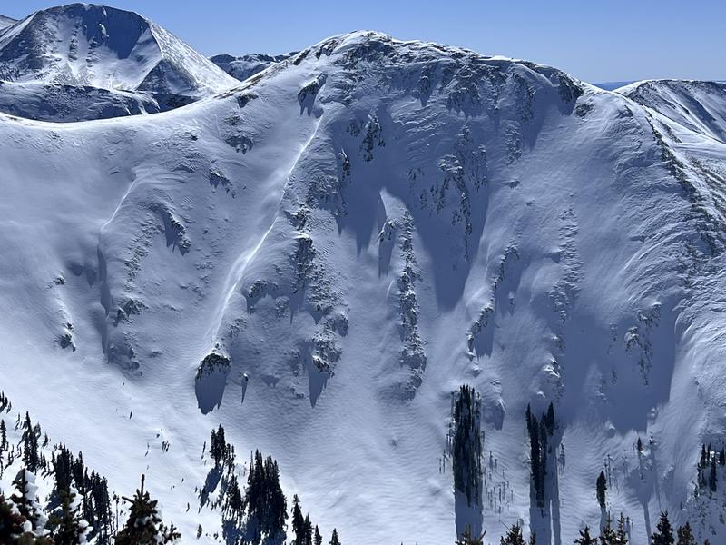
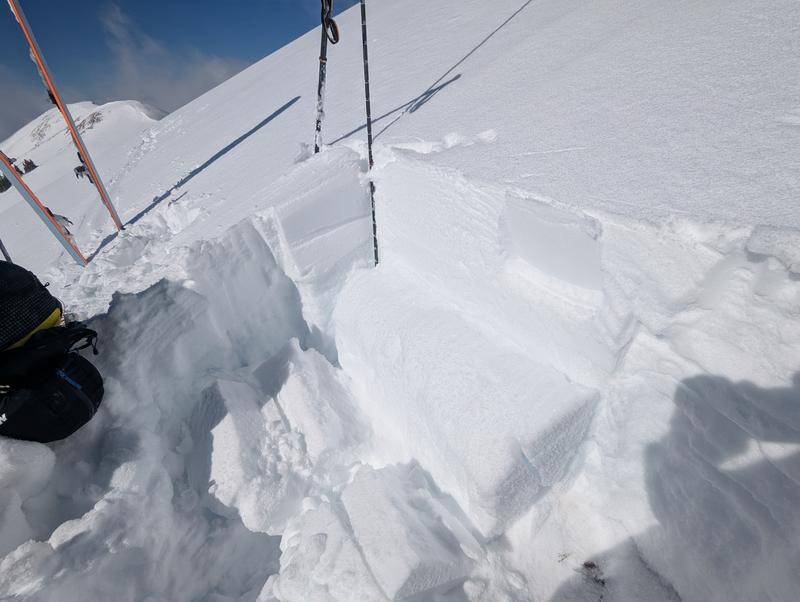
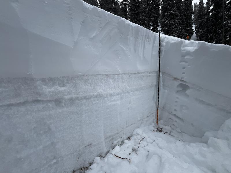
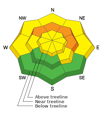
Although we are trending towards an overall moderate danger rating, CONSIDERABLE avalanche danger can still be found on steep, northerly aspects near treeline. In these areas, human triggered avalanches 2 feet deep or more, failing on a persistent weak layer of faceted snow, are likely.
The danger is MODERATE on most all other slopes facing W-N-E-SE. Moderate does not mean good to go, and human triggered avalanches failing on this weak layer are possible, to highly possible, especially on steep northerly aspects. In these areas, you are trusting a slab over a weak layer and hoping you don't find the "sweet" spot.
Most south and southwest facing terrain has LOW danger. Small avalanches on isolated terrain features are possible. This includes loose wet slides as the day heats up. Avoid steep slopes if they become wet and sloppy.
Low
Moderate
Considerable
High
Extreme
Learn how to read the forecast here
Special Avalanche Bulletin
The Utah Avalanche Center is issuing a statewide Special Avalanche Bulletin after a series of storms in the last week has left a thick blanket of snow at all elevations, creating excellent powder riding conditions while also elevating the backcountry avalanche danger. In Moab, we haven't received significant snow in a week, but conditions remain dangerous. Don't let the sunshine influence your decision-making - careful snowpack and terrain analysis are required for backcountry travel. Fortunately, there are great riding and travel conditions away from avalanche terrain on slopes less than 30° in steepness.
Special Announcements
Geyser Pass Road: The road is plowed to the winter trailhead. It remains slick and snow packed. AWD and good tires recommended.
Grooming Conditions: All trails were groomed on Friday.
Weather and Snow
6 A.M. Snow and Weather Data
24 Hour Snow: 0" 72 Hour Snow: 2" Season Total Snow: 82" Depth at Gold Basin: 40"
Winds on Pre-Laurel Peak: NW 10 Temp: 13° F Percent of Normal (SWE): 72%
Weather
Northwest winds picked up a bit overnight averaging 15 mph along ridge tops with occasional gusts in the 20's. Mountain temperatures are in the mid teens. Another sunny day is on tap with high temperatures creeping up to near 40°F at 10,000'. Sunny skies and warm temperatures remain through the upcoming week.
General Conditions
This past week has seen the best turning and riding of the season and it's been great to see the community getting after it. To recap, 2 inches fell on Feb 11, followed by 15 inches at 2.5 inches of Snow Water Equivalent on Feb 14, a very significant load for the underlying, fragile snowpack. Widespread collapsing last weekend has since become more isolated, or localized, but the snowpack is still talking. See this observation from Alex Mudler. The 2 inches that fell on Feb 11 quickly faceted and became a widespread weak layer on all aspects. This has since quieted down, but deeper faceted layers in the snowpack remain reactive on northerly aspects near treeline (see video below). Another 2-4 inches fell on Thursday bringing a nice refresh to the snow surface. Above treeline, winds have affected the snow surface, while strong sun and warmer temperatures over the past couple of days dampened the snow on solar aspects and most will be crusted over this morning.
Chris Benson ventured up into the high country yesterday (read his observation) where he found firm snow and wind blasted surfaces. Prior to the Feb 14 storm much of the snow had been stripped away and the new snow is all we have. What snow remained was hard and firm. The most concerning areas above treeline are where the Feb 14 snow has drifted and formed hard slabs, possibly over weak, faceted snow.
Areas of wind drifted snow on a northerly aspect above treeline. Chris Benson photo.
Snowpack and Weather Data
Gold Basin SNOTEL site (10,000')
SNOTEL site near Geyser Pass Winter Trailhead (9600')
Wind Station on Pre-Laurel Peak (11,400')
NWS forecast for the La Sal Mountains.
Recent Avalanches
Ad
Avalanche Problem #1
Persistent Weak Layer
Type
Location
Likelihood
Size
Description
The Valentine's Day storm has built a dense, cohesive slab on top of our weak, underlying snowpack. On northerly aspects, the entire snowpack is faceted through with varying degrees of hardness, but a layer of fist hard facets exist directly beneath the slab. Outward signs of instability such as collapsing and whumphing have decreased significantly but they are still being observed, and stability tests remain reactive. The bottom line is that human triggered avalanches up to 2 feet deep or more, failing on this weak layer remain highly possible. The danger is most prevalent on northerly aspects near treeline but don't think you can outsmart it by changing elevation. For the foreseeable future, I'll be avoiding all slopes steeper than 30 degrees on all northerly aspects.
As you wrap around to west, the problem still exists and it's a fine line between shady and sunny. Many westerly aspects still present as northerly if there are trees to provide shade. West facing slopes should be considered guilty until proven innocent, and a slope by slope analysis is required.
Last weekend, a reactive layer of facets was observed on a south facing slope and on Friday, Travis Nauman found a reactive layer beneath a crust on an upper elevation SW aspect. I suspect warm temperatures and further crusting of the snow surface has alleviated this problem, but if you approach a steep, south facing slope that has good coverage, it's worth digging down to have a look at the structure. If you can find a slab on top of facets you should reconsider your objective.
Reactive stability test on a SW aspect above treeline. Travis Nauman photo.
The bottom line is that our snowpack this season is tenuous and weak, and it still remains quite immature. Weak, faceted snow beneath the Feb 14 slab is not going away anytime soon, and avoiding steep, northerly aspects, especially near treeline, is the most prudent strategy.
Photo illustrates weak, faceted layer underneath the most recent snow on a WNW aspect at 10,800' Extended column tests produced results of ECTP 21 and ECTP 14 on this weak, faceted layer.
Additional Information
Check out the latest edition of the UAC podcast with Moab forecaster Dave Garcia where he talks about the challenges of forecasting for our remote and isolated range with limited information.
Sign up for text alerts to get the most up to date information about changing conditions, road plowing, special avalanche announcements.
Follow us on Instagram @utavy_moab
General Announcements
This forecast is from the U.S.D.A. Forest Service, which is solely responsible for its content. This forecast describes general avalanche conditions and local variations always occur.