Join us for the 33rd Backcountry Benefit - Get Your Tickets Now!

Forecast for the Moab Area Mountains

Eric Trenbeath
Issued by Eric Trenbeath on
Sunday morning, February 15, 2026

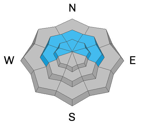
A MODERATE avalanche danger exists on steep slopes near and above treeline that face W-N-E. In these areas, human triggered soft slab avalanches failing on a persistent weak layer of faceted snow are possible.

Moderate means the danger isn't widespread but there are areas where you can trigger an avalanche. You are most likely to find trouble on steep, wind drifted slopes right around treeline and above that have a north or easterly component to their aspect. Signs of instability include collapsing and cracking in the snow surface. Avoid steep slopes where these signs are present and be mindful of overhead hazard.

Low
Moderate
Considerable
High
Extreme
Learn how to read the forecast here
Special Announcements

Geyser Pass Road Conditions: The recent snow has been well packed in by traffic. Icy conditions exist up high and it's melted out to the dirt down low. AWD with good tires recommended.

Grooming: LUNA groomed all trails yesterday.

We have rescheduled our Moab Backcountry 101 Class to February 20, 21. Click here for information and registration. Moab and Monticello locals can use the discount code MOAB-LOCAL for a 10% discount.

Weather and Snow

24 Hour Snow: 0" 72 Hour Snow: 1" Season Total Snow: 49" Depth at Gold Basin: 30"

Winds on Pre-Laurel Peak: S 20-25 G 32 Temp: 27°F

Weather

Look for warm, cloudy, and breezy conditions in the mountains today as a low pressure trough approaches the California coast. High temps will be in the mid to upper 30's at 10,000 feet and winds blowing from the southwest will average 15-25 mph along ridge tops. Monday will be even warmer and breezier with continued southwest winds blowing in the 20-30 mph range with gusts as high as 50 mph along ridge tops. Snowfall should begin late Monday night with highest rates of precipitation arriving Tuesday morning. The pattern remains active through the week and the arrival of a cold front on Wednesday looks to bring us perhaps our best shot of snow.

General Conditions

Although we were hoping for more, the 5 inches of new snow we received last week really helped conditions and it was a sunny powder day in the mountains yesterday. It was very warm, however, and by afternoon, sun exposed slopes were damp and gloppy and they'll be crusted over this morning. On Friday, Jason Ramsdell and I observed a fair amount of cracking and soft slab formation in the most recent snow but yesterday, Dave and I observed little to none. The recent snow is sitting on top of weak, sugary, faceted snow, and although it hasn't been enough to tip the scales, the pump is primed. An increase in southerly winds overnight will likely move some snow around resulting in fresh, shallow slabs on northerly aspects and adding just a little more stress to buried weak layers. Evaluate terrain carefully today and avoid steep slopes with recent deposits of wind drifted snow.

For more on conditions yesterday check out these observations from Reed Kennard and Ryan Huels.

See all recent observations here.

Snowpack and Weather Data

SNOTEL site near Geyser Pass Winter Trailhead (9600')
Wind Station on Pre-Laurel Peak (11,400')
NWS forecast for the La Sal Mountains.
Recent Avalanches
See all La Sal avalanches here.
Avalanche Problem #1
Persistent Weak Layer
Type
Location
Likelihood
Size
Description

Underneath the recent snow, the snowpack is entirely faceted through on shady aspects providing a variety of weak layers. Although the recent snow has not provided enough of a load to completely tip the scales, the trigger is set and human triggered avalanches failing on a persistent weak layer are possible. The immediate layer of concern is right beneath the recent snow. Soft slab avalanches failing on this layer could be up to a foot deep and 100 feet wide. A less likely scenario would be for a failure to occur deeper in the snowpack but if we increase the load this week, this scenario will become all but certain.

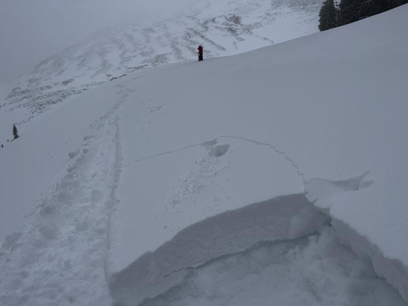
Slab within the recent snow failing on a layer of now buried, near surface facets. The snowpack is primed and ready for avalanches.

Avalanche Problem #2
Wind Drifted Snow
Type
Location
Likelihood
Size
Description

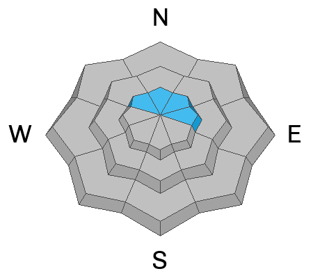
Look for fresh slabs of wind drifted snow on slopes facing NW-N-NE-E. These fresh, shallow deposits would be mostly inconsequential but the concern will be their possible effects on buried weak layers in the snowpack. For this reason, steep slopes with recent deposits of wind drifted snow should be avoided. Wind drifted slopes often have a smooth rounded appearance, and cracking is a sign of instability.

Additional Information
General Announcements
This forecast is from the U.S.D.A. Forest Service, which is solely responsible for its content. This forecast describes general avalanche conditions and local variations always occur.