AVALANCHE WARNING!! Tap for info
UDOT PLANNED AVALANCHE CLOSURES!!

Forecast for the Moab Area Mountains

Eric Trenbeath
Issued by Eric Trenbeath on
Saturday morning, February 1, 2025
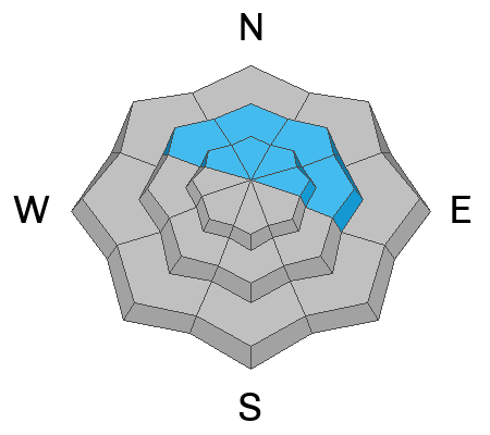
Strong southerly winds have increased the danger to MODERATE and human triggered avalanches are possible on steep wind drifted slopes near and above treeline that face NW-N-NE-E. The danger is most prevalent right around treeline. Avoid steep slopes where you can detect recent deposits of wind drifted snow.
Most other terrain has LOW danger. Small avalanches on isolated terrain features are possible.
Low
Moderate
Considerable
High
Extreme
Learn how to read the forecast here
Special Announcements
Check out the latest edition of the UAC podcast with Moab forecaster Dave Garcia where he talks about the challenges of forecasting for our remote and isolated range with limited information.
Urgent battery replacement required for anyone who received batteries from one of our participating "Batteries for Beacons" shops. Please review the "Batteries for Beacons" replacement notice on our blog. Batteries distributed through our "Batteries for Beacons" program this year have shown to be inadequate length.
Geyser Pass Road: Surface is mainly snowpacked and icy above and bare dirt down low. AWD with good tires recommended.
Grooming Conditions: Trails were last groomed on Wednesday.
Weather and Snow
6 A.M. Snow and Weather Data
24 Hour Snow: 0" 72 Hour Snow: 0" Season Total Snow: 63" Depth at Gold Basin: 29"
Winds on Pre-Laurel Peak: S 20-25 G 35 Temp: 30° F Percent of Normal (SWE): 71%
Weather
Southerly winds associated with an Atmospheric River event have been on the increase since yesterday afternoon and are currently blowing moderate to strong along ridge tops. Unfortunately for us, that's all we're going to see as the action stays well to the north. Today look for partly sunny skies, warm temperatures in the mid to upper 30's, and continued breezy conditions. Sunday will be mostly sunny, breezy and even warmer. The second wave of this system already looks to be weakening as a it moves south along the West Coast on Tuesday. As a result, our chances for snow next week have diminished.
General Conditions
It's no secret that our snowpack is thin, variable, and very weak in many areas. Winds first from the north, and now the south have been transporting and drifting loose surface snow into isolated cohesive slabs. We may find them to be a little more widespread today, primarily on northerly aspects near treeline. Above treeline, they'll be more isolated due to the overall wind scoured nature of things up there. On shady aspects below treeline, the entire snowpack consists of loose, non-cohesive, faceted snow. Small, loose dry avalanches are possible in steep terrain. Looking ahead, this weak faceted snow will make an unstable base for future snow loads. It's still low tide out there and the weakening snowpack makes hitting buried obstacles more likely so be careful out there.
Snowpack and Weather Data
Gold Basin SNOTEL site (10,000')
SNOTEL site near Geyser Pass Winter Trailhead (9600')
Wind Station on Pre-Laurel Peak (11,400')
NWS forecast for the La Sal Mountains.
Recent Avalanches
Ad
Avalanche Problem #1
Wind Drifted Snow
Type
Location
Likelihood
Size
Description
Shifting winds this week have created unstable slabs of wind drifted snow. Look for them on the leeward sides of ridge crests and terrain features, primarily on northerly aspects right around treeline. Wind drifts are recognizable by their smooth, rounded appearance, and cracking is a sign of instability. In many cases, recent drifts are sitting on top of loose, weak faceted snow, making them more sensitive to the weight of a skier or rider. Avoid steep slopes that have recent deposits of wind drifted snow.
Additional Information
Sign up for text alerts to get the most up to date information about changing conditions, road plowing, special avalanche announcements.
Follow us on Instagram @utavy_moab
General Announcements
This forecast is from the U.S.D.A. Forest Service, which is solely responsible for its content. This forecast describes general avalanche conditions and local variations always occur.