Check Out Our Holiday Auction!

Forecast for the Moab Area Mountains

Eric Trenbeath
Issued by Eric Trenbeath on
Saturday morning, December 6, 2025
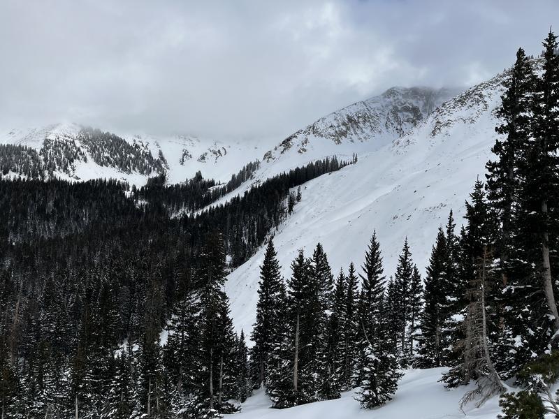
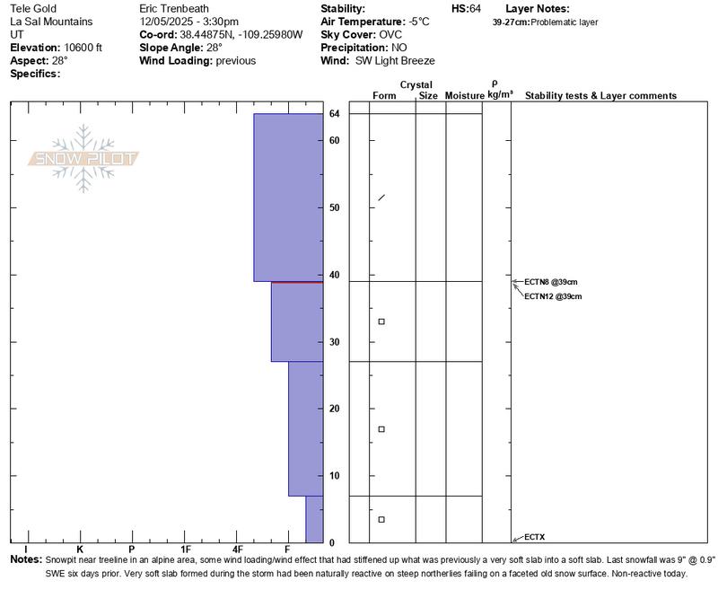
An isolated or MODERATE avalanche danger exists on steep, wind drifted slopes above tree line that face NW-N-NE-E. In these areas, older slabs of wind drifted snow are overriding layers of weak, sugary, faceted snow and human-triggered avalanches are possible. Additional wind drifting today could compound the problem. Look for fresh deposits on these same aspects but also be wary of slopes facing SE.
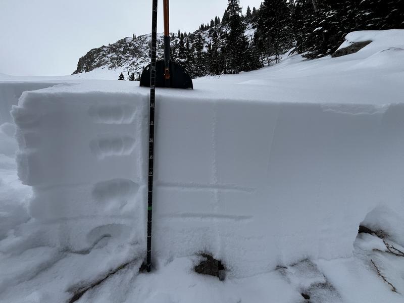
Even though today's avalanches are likely to be shallow and confined to small areas, they could still have serious consequences due to our thin early-season snowpack. Most other terrain has generally LOW danger.
Conditions remain very thin, and rocks, stumps, and logs lurk below the surface everywhere. There still isn't enough snow for real turning and riding. Exercise extreme caution getting around.
Low
Moderate
Considerable
High
Extreme
Learn how to read the forecast here
Special Announcements

Geyser Pass Road Conditions: The road has been plowed but the surface is snowpacked and slick. All wheel drive and good tires recommended.

Grooming: The Geyser Pass road above the trailhead will close to vehicles on Dec 15. Grooming will commence after that.

It's Avalanche Awareness Week!

Saturday, December 6 - 18th Annual Utah Snow and Avalanche Workshop (USAW). This session will be available to live stream or attend in person at the Wasatch Jr High School Auditorium. 3750 S 3100 E, Salt Lake City, UT 84109. Information and tickets are available here.

Saturday, December 13 - Moab Winter Kick Off Party at the MARC Bring your skis or board to wax, listen to live music, and bring in another winter season with our local community. Tickets available online now!

Friday, January 30 - Saturday, January 31 - Moab Backcountry 101 Class - Our annual local backcountry avalanche class. Click here for information and registration. Moab and Monticello locals can use the discount code MOAB-LOCAL for a 10% discount.

Weather and Snow

24 Hour Snow: 0" 72 Hour Snow: 0" Season Total Snow: 21" Depth at Gold Basin: 16"

Winds on Pre-Laurel Peak: 10-15 WSW Temp: 26° F

Weather

Cloudy skies with a lingering chance for snow showers this morning should turn partly sunny as the day progresses. Look for blustery, west northwest winds averaging 15-20 mph along ridge tops. High temperatures will be in the low 20's at 10,000'. Sunday looks clear with warmer temperatures. We'll see a gradual warming trend through next week. The long range picture looks bleak. High pressure off the Southern California coast is forcing systems to the north leaving us high and dry for the foreseeable future.

General Conditions

Conditions are thin with average snow depths ranging from about 16-24 inches. The underlying snowpack is weak and faceted, allowing skis to punch deep when skiing downhill and attempting to make turns. Rocks and logs are a real hazard, and the punchy snow doesn't help. Weak snow can now be found on all aspects and with the extended dry period ahead it will become weaker. The soft slab that formed from last Sunday's 9 inches remains quite soft and has largely relaxed. It's a little stiffer in wind affected areas, especially above tree line, and this is where you are most likely to find problems. For more details, see my observation from yesterday. Sam Van Wetter made it up the Laurel Highway yesterday and braved the woods on his way down. See his observation here. It's thin in there to say the least.

Want some good news? This is actually a fairly normal start for us and we are sitting at over 90% Snow Water Equivalent (SWE) for this time of year. There's plenty of snow on the dirt roads to get up and slide around on and we'll just have to be patient.

It is what it is...

Check out recent observations here.

Snowpack and Weather Data

NEW! Gold Basin webcam storm stake

Gold Basin Storm Stake (10,000')

Gold Basin SNOTEL site (10,000')
SNOTEL site near Geyser Pass Winter Trailhead (9600')
Wind Station on Pre-Laurel Peak (11,400')
NWS forecast for the La Sal Mountains.
Recent Avalanches
No avalanche activity has been reported since this avalanche in Colorado Bowl on Monday. Click here for the complete avalanche database.
Avalanche Problem #1
Persistent Weak Layer
Type
Location
Likelihood
Size
Description

We're moving toward a classic La Sal set up with a persistent weak layer of sugary, faceted snow at the base of the snowpack. All of the snow that fell between Nov 16-19 has begun to facet and weak snow can be found on all aspects. In most cases, however, the soft slab that formed and produced avalanches on Nov 30 has become largely non-reactive. Areas of exception are primarily on north and easterly aspects above tree line where winds have drifted snow and thickened slabs on top of the pre-existing, weaker snow, and this is where you are most likely to find trouble.

The photo and snowpit below illustrate my findings on a NE aspect near tree line at 10,600'. The overriding soft slab is slightly denser here than in other locations, and the base is obviously growing weaker, but three extended column tests failed to produce propagation.

Avalanche Problem #2
Wind Drifted Snow
Type
Location
Likelihood
Size
Description
Blustery ridge top winds today may pick up snow that's available for transport and re-deposit it into shallow, fresh drifts on slopes with a northwest through southeast aspect. Fresh drifts are recognizable by their smooth, rounded appearance and cracking is a sign of instability. In most situations these shallow, fresh drifts would be fairly innocuous, but in the current case they may add to older drifts compounding the persistent weak layer problem. For this reason, the best strategy is to avoid steep, freshly wind drifted slopes.
Additional Information

Thanks to everyone who attended our Know Before You Go session on Wednesday night!

It's never too early to start thinking about avalanches. Here are a few things to consider doing:

  • Learn online. We have over 5 hours of free online learning at the Know Before You Go website
  • Check out the upcoming in-person Know Before You Go events HERE
  • Sign up for an on-snow class
  • Check out the UAC's education progression HERE
  • Get your avalanche rescue gear ready for winter. Put fresh batteries in your transceiver and update the firmware. Inspect your shovel and probe. Get your airbag backpack ready by possibly doing a test deployment and updating the firmware if it is an electric version or getting your canister refilled if it's not electronic.
General Announcements
This forecast is from the U.S.D.A. Forest Service, which is solely responsible for its content. This forecast describes general avalanche conditions and local variations always occur.