UDOT PLANNED AVALANCHE CLOSURES!!

Forecast for the Moab Area Mountains

Eric Trenbeath
Issued by Eric Trenbeath for
Sunday, December 4, 2022
A MODERATE avalanche danger exists on slopes that face NW-N-E near treeline and above where slabs of wind drifted snow exist on top of a weak, fragile snowpack. Human triggered avalanches are possible on these slopes. South and westerly facing slopes and most areas below treeline terrain have LOW danger.
It's still low tide out there and rocks, stumps, and deadfall are lurking just beneath the surface. A ride in even a small avalanche in these low snow conditions would be rugged.
Low
Moderate
Considerable
High
Extreme
Learn how to read the forecast here
Special Announcements
We will be giving a free Know Before You Go Avalanche Awareness talk on Tuesday, Dec 6 at 6:00 p.m. at the MARC (111 E 100 N).
Join us for the 1st Annual UAC Moab/LUNA Winter Kickoff Party on Saturday, Dec 10 at the MARC. The event will be from 7-9 PM. Get your tickets here.
Join the Utah Avalanche Center and the Division of Outdoor Recreation to celebrate the Fourth Annual Avalanche Awareness Week, from December 4 - December 11. Click HERE to view a full list of events throughout the state.
Road Conditions: Grand County has not yet begun plowing the road to Geyser Pass Trailhead. The road is hard-packed snow and slick in places. Good tires and all wheel drive are recommended.
Grooming: The Geyser Pass Road above the winter trailhead closes on Dec 15. Grooming will commence after that, but but for now, the road above the trailhead is snowpacked and well traveled and cross country ski conditions are pretty good.
Weather and Snow
24 Hour Snow 0" 72 Hour Snow 0" Season Total Snow 41" Base Depth at Gold Basin 24"
Winds on Pre Laurel Peak SSE 23 G30 Temp 31F
Southerly winds continue to blow and temps are quite warm this morning, hovering around freezing at 10,000'. Cloudy skies, breezy SW winds, and warm temps will characterize the day. Unsettled weather continues through the week with our next chance for measureable snow still looking like Wednesday followed by another system next weekend. Long range models advertise a train of troughs through mid month with some of them dipping down into our zone. Keep the dream alive!
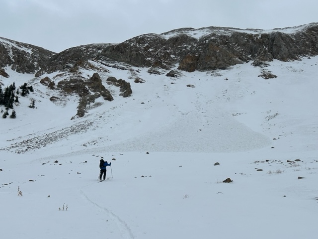
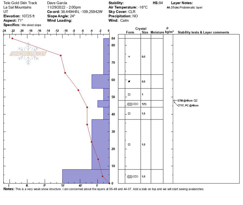
A ravaged snowscape currently exists up there. Strong, gusty, and erratic south through northwesterly winds the past week have alternately deposited, scoured, and re-deposited snow again on a variety of slopes near and above treeline. For more on that, see this observation from Dave Garcia and Nate Ament. A complex pattern of winddrifts are sitting on top of a foundation of weak, sugary, faceted snow. The bottom line is that the snowpack isn't shaping up all that well and we will soon be facing a persistent weak layer problem. It's also still low tide out there with lots of rocks, stumps, and logs lurking about.
Gold Basin Storm Stake (10,000')
Gold Basin SNOTEL site (10,000')
SNOTEL site near Geyser Pass Winter Trailhead (9600')
Wind Station on Pre-Laurel Peak (11,400')
NWS forecast for the La Sal Mountains.
If you are getting up into the mountains please submit an observation and let us know what you are seeing!
Recent Avalanches
Dave Garcia and Nate Ament observed this recent wind slab release on Saturday, Dec 3.
Ad
Avalanche Problem #1
Wind Drifted Snow
Type
Location
Likelihood
Size
Description
Strong, erratic winds have creatd a complex landscape. Recent slabs of wind drifted snow exist on top of older ones, although due to the amount scouring, they are isolated. Basically, any slope facing NW through N through E. that has enough snow to ride is susp[ect. Wind slabs are recognizable by their smooth, rounded, "pillowy" appearance and they may sound hollow underneath. Cracking is a sign of instability. Look for unstable areas of wind drifted snow on the the leeward sides of ridge crests and terrain features such as rock outcroppings, sub ridges, and gully walls. Due to higher wind speeds, they may also exist further down slope than you expect. Avoid steep slopes that have recent deposits of wind drifted snow.
Avalanche Problem #2
Persistent Weak Layer
Type
Location
Likelihood
Size
Description
We are carefully monitoring the snowpack as the underlying structrure is very weak and comprised almost entirely of loose, weak, sugary, faceted snow on W-N-E aspects. A widespread cohesive slab has not yet developed, but in areas that have complex layers of wind drifted snow, a weak, faceted layer will produce the failure. Expect this problem to become more widespread when we add more snow.
Additional Information
This snow profile shows our very weak snowpack that was buried by seven inches of snow on Monday.
General Announcements
This forecast is from the U.S.D.A. Forest Service, which is solely responsible for its content. This forecast describes general avalanche conditions and local variations always occur.