Join us at our 2nd Annual Blizzard Ball

Forecast for the Moab Area Mountains

Eric Trenbeath
Issued by Eric Trenbeath on
Wednesday morning, December 30, 2020
12"-20" of new snow has added a significant load to our weak, underlying snowpack and the avalanche danger is CONSIDERABLE on steep, northerly facing slopes that had a foot or more of pre-existing snow. In these areas, new and wind drifted snow has piled on top of layers of weak, sugary, faceted snow. This persistent weak layer problem will be with us for the foreseeable future and though overall low coverage will make it difficult to access these areas, steep, northerly facing slopes should be avoided. Even a small avalanche triggered under these conditions can have serious and painful consequences. South-facing slopes have a LOW to MODERATE danger for avalanches involving new and wind drifted snow due to spotty or non-existent prior snow cover.
Low
Moderate
Considerable
High
Extreme
Learn how to read the forecast here
Special Announcements
The Geyser Pass Road will be getting plowed this morning. Expect the gate to be closed while plowing is in progress.
The Lower Utah Nordic Alliance (LUNA) packed out trails yesterday and will be back up grooming today.
Weather and Snow
24 Hour Snow 0" 72 Hour Snow 15" Base Depth in Gold Basin 32" Wind N 10-15 G25 Temp 2F
Skies are clear and temps have crashed. Overnight northerly winds have been mostly light but they started bumping up around 5:00 a.m. It will be a beautiful day in the mountains with sunny skies, fresh snow, and high temps in the mid 20's. We'll see clouds on Thursday as weak disturbance clips by to the north. Dry conditions return through the weekend though we may see some clouds as several troughs move through the northern regions. Long-range models hint at one of these troughs dropping down over our area early next week.
Wind, temperature, humidity on Pre Laurel Peak (11,700')
Snotel site near Geyser Pass Trailhead (9600').
NWS weather forecast
Snowpack Discussion
A foot of new snow has fallen at the Geyser Pass Trailhead with 1" of SWE (Snow Water Equivalent). 15" fell in Gold Basin with up to 20" up high. Needless to say, this load has added significant stress to our fragile snowpack. In our travels yesterday we observed widespread collapsing and cracking as well as several natural avalanches that ran during the height of the storm. On northerly aspects, layers of weak, sugary, faceted snow exist on top of a slick, hard melt-freeze layer. Overall coverage is still quite thin. Prior to this storm, snow depths ranged from about 6" at Geyser Pass Trailhead to 18" at Geyser Pass. Most south-facing slopes were bare. The new snow will hide a myriad of obstacles such as rocks and deadfall that lurk just beneath the surface so keep your enthusiasm in check and stick to low angle grass slopes and meadows. For more details see this observation from Chris Benson.
Recent Avalanches
In our travels yesterday we observed several natural avalanches in Gold Basin. Most were "pockety" in nature, averaging less than 50' wide due to an overall lack of connectivity at this time. They also tended to release further downslope, likely due to a lack of pre-existing snow higher up as well as strong winds depositing snow further down. I'll have an updated list soon.
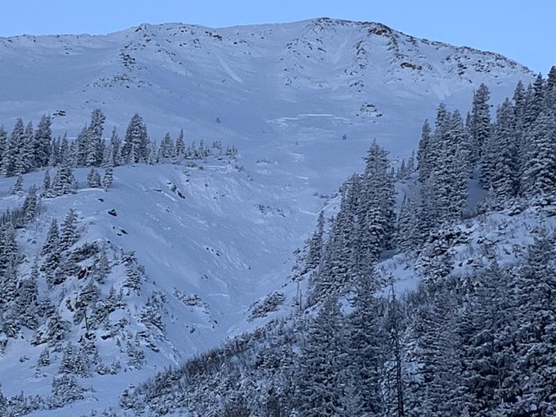
This avalanche on the NE face of Mount Tukno was a bit of an exception as it found more snow to connect with as it ran down through the gully. Also, note the likely sympathetic release on the looker's lower left.
Ad
Avalanche Problem #1
Persistent Weak Layer
Type
Location
Likelihood
Size
Description
A significant load has been added to our fragile snowpack. On mid and upper elevation northerly aspects, the snowpack has deteriorated into layers of weak, sugary, faceted snow on top of a slick, hard bed surface. This has created a persistent weak layer problem that will stick with us for some time. Although avalanche terrain remains difficult to access due to low coverage, human-triggered avalanches are likely in these areas and steep, northerly facing terrain will remain off limits for the foreseeable future.
This video was taken a week ago, and it illustrates the poor snowpack structure that now sits underneath the new snow.
Avalanche Problem #2
Wind Drifted Snow
Type
Location
Likelihood
Size
Description
Unstable areas of wind drifted snow exist on the leeward sides of ridge crests and terrain features in exposed terrain. Wind drifts are recognizable by their smooth rounded appearance and cracking is a sign of instability. In most cases, a triggered wind drift will most likely step down into a persistent weak layer of sugary, faceted snow. Avoid steep slopes with areas of wind drifted snow.
Additional Information
For an in-depth look at how the early season snow history has lead to these conditions, check out this blog post from Chris Benson.
General Announcements
This forecast is from the U.S. Forest Service, which is solely responsible for its content. This forecast describes general avalanche conditions and local variations always occur.