Forecast for the Moab Area Mountains

Eric Trenbeath
Issued by Eric Trenbeath for
Wednesday, December 27, 2023
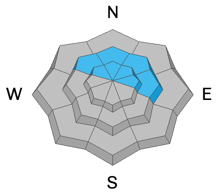
The avalanche danger remains MODERATE today. On steep slopes above treeline, human triggered avalanches involving slabs of wind drifted snow are possible on all aspects.
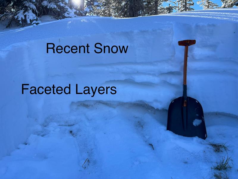
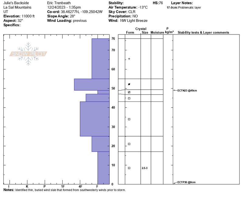
On steep, northerly aspects, triggered slabs may step down into buried weak layers of sugary, faceted snow. We are in the early phase of a developing snowpack and it is shallow, weak, and untrustworthy. A ride in any avalanche, no matter how small, would be rugged in these conditions.

Low snow conditions exist and there are many obstacles such as rocks, stumps, and logs lurking just beneath the surface.
Low
Moderate
Considerable
High
Extreme
Learn how to read the forecast here
Special Announcements
To fulfill our mission, the UAC relies on our amazing backcountry community. Your support helps pay for the daily avalanche forecast, free awareness presentations across the state, and new tools like the new Avalanche and Observation Explorer. As the end of the year approaches, please consider donating to the UAC.
Road Conditions: The road is plowed but the surface remains soft. AWD with good tires are required.
Grooming: Trails have not been groomed since Sunday.
Weather and Snow
6:00 a.m. Snow and Weather Data
24 Hour Snow 0" 72 Hour Snow 0" Season Total Snow 42" Base Depth at Gold Basin 24"
Winds on Pre-Laurel Peak: NW 10-15 Temp 10˚ F

Weather
After a relentless run, NW winds are finally starting to back off averaging 10-15 mph along ridge tops. Temps will be on the rise today reaching the mid to upper 20's at 10,000'. Sunny skies and dry weather continue through the remainder of the week.

General Conditions
Winds have hammered our nascent snowpack. On Saturday, 8" of medium density snow fell, the first snowfall in over two weeks. NW winds over the past few days have alternately scoured and drifted snow. Some areas will be stripped bare, while others will have stiff slabs of drifted snow. Underneath, the pack is loose, weak, and shallow. Dave Garcia will be up today to survey the damage. Additionally, rocks, stumps and dead fall are lurking everywhere. Sticking to roads, known grassy meadows, and low angle slopes remains the best strategy.
Snowpack and Weather Data
Gold Basin Storm Stake (10,000')
Gold Basin SNOTEL site (10,000')
SNOTEL site near Geyser Pass Winter Trailhead (9600')
Wind Station on Pre-Laurel Peak (11,400')
NWS forecast for the La Sal Mountains.
Recent Avalanches
No recent avalanches have been reported.
Ad
Avalanche Problem #1
Wind Drifted Snow
Type
Location
Likelihood
Size
Description
Human triggered avalanches involving slabs of wind drifted snow are possible at upper elevations on all aspects today. NW winds are tricky in the La Sals and cross-loading is a factor, even on northerly aspects. Suspect all slopes that show signs of recent wind loading. Fresh drifts are recognizable by their smooth, rounded appearance, and cracking is a sign of instability. Triggered wind slabs have the potential to step down into weaker faceted layers. Avoid steep, wind drifted slopes.
Avalanche Problem #2
Persistent Weak Layer
Type
Location
Likelihood
Size
Description
There's no way around this, we are developing a persistent weak layer problem. Outward signs of instability may not be present, and stability tests are somewhat inconclusive, but the structure is poor, we've recently added an inch of water, and winds continue to blow and drift fresh slabs on top. Areas that have the most snow and that seem rideable, are also where you are likely to find trouble. We might as well develop the mindset that steep, northerly aspects are likely going to be off limits for awhile.
Additional Information
For the snow geeks out there, here is a profile of the above photo:
General Announcements
This forecast is from the U.S.D.A. Forest Service, which is solely responsible for its content. This forecast describes general avalanche conditions and local variations always occur.