Join us at our 2nd Annual Blizzard Ball

Forecast for the Moab Area Mountains

Eric Trenbeath
Issued by Eric Trenbeath on
Saturday morning, December 24, 2022
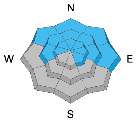
A MODERATE danger for human triggered avalanches failing on a buried persistent weak layer exists on slopes that face W-N-SE. The danger is greatest on steep northerly aspects near treeline and above where recently wind drifted snow has built thick slabs and added more stress to this buried weak layer. Dangerous, human triggered avalanches 2'-4' deep remain possible and slopes steeper than 30 degrees should be avoided in these areas. Most south facing terrain has generally LOW danger.
Low
Moderate
Considerable
High
Extreme
Learn how to read the forecast here
Special Announcements
As the end of the year approaches, please consider a donation to the UAC to support avalanche forecasting.
Road Conditions: The road is snowpacked and slick. AWD and good tires are required.
Grooming: LUNA groomed all trails yesterday. Thanks John!
Weather and Snow
24 Hour Snow 1" 72 Hour Snow 1" Season Total Snow 80" Base Depth at Gold Basin 40"
Winds on Pre Laurel Peak NW 5-10 Temp 15F
Weather
Warm and dry conditions are on tap through Christmas. Under sunny skies, high temps will be in the upper 20's at 10,000' and northwesterly winds will be light. You may as well get out and enjoy the beautiful weather while it's here, models are pointing to a significant change by midweek.

General Conditions
Strong NW winds mid-week have had their way with the snow surface and you can expect to find a combination of crusted, scoured, and alternately wind loaded slopes near and above treeline. You can still find nice, settled powder in shady, sheltered locations. Recent wind loading continues to apply pressure to a buried persistent weak layer of faceted snow, particularly on steep, northerly aspects near treeline and above, and human triggered avalanches 2'-4' deep remain possible.
If you're getting out in the backcountry please let us know what you are seeing by submitting an observation . Here are the most recent observations.

Snowpack and Weather Data
Gold Basin Storm Stake (10,000')
Gold Basin SNOTEL site (10,000')
SNOTEL site near Geyser Pass Winter Trailhead (9600')
Wind Station on Pre-Laurel Peak (11,400')
NWS forecast for the La Sal Mountains.
Recent Avalanches
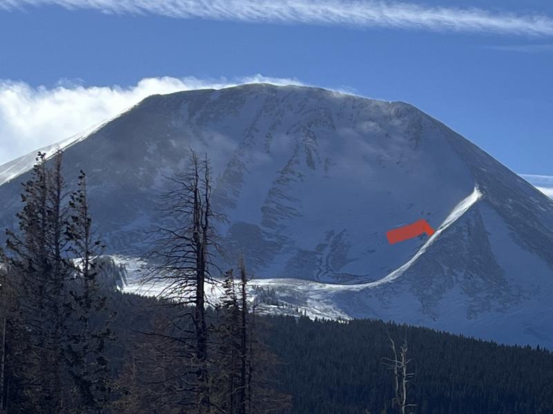
Strong northwesterly winds overloaded the shoulder on the N face of Mount Mellenthin to produce this natural avalanche sometime Wednesday night or early Thursday morning. Not particularly wide, but upwards of 3' deep, this type of problem continues to be our primary concern. Note the completely scoured, windward side of the ridge, and the loaded leeward side where the avalanche occurred.
Here is a complete list of avalanches in the La Sals.
Ad
Avalanche Problem #1
Persistent Weak Layer
Type
Location
Likelihood
Size
Description
A persistent weak layer of faceted snow that developed during the cold dry period in mid November still exists on W-N-SE aspects. Obvious signs of instability such as collapsing and cracking are not present but a poor snowpack structure, consisting of strong snow over weak snow, still exists. Slopes facing NW-N-E, near treeline and above, are the most suspect. In these areas wind drifted snow has built thick slabs on top of the weak layer. These hard slabs are 1-4' thick and can produce very large, deep, and potentially deadly avalanches. Over time, these weaknesses can heal but it's still early season and for now, keeping your slope angles under 30 degrees is the best strategy for terrain on the north side of the compass.
Additional Information
For a personal account of a human triggered avalanche, failing on a persistent weak layer during a period of moderate danger, see Eric's blog post here.
General Announcements
This forecast is from the U.S.D.A. Forest Service, which is solely responsible for its content. This forecast describes general avalanche conditions and local variations always occur. This forecast will be updated by 7:30 tomorrow morning.