Join us at our 2nd Annual Blizzard Ball

Forecast for the Moab Area Mountains

Dave Garcia
Issued by Dave Garcia on
Wednesday morning, December 18, 2024
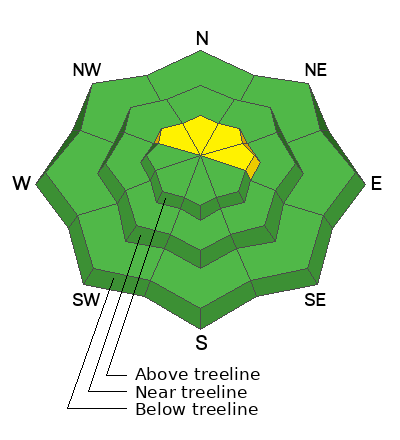
MODERATE danger remains on steep slopes above treeline that face NW-N-NE-E. Human-triggered avalanches failing on a persistent weak layer are possible. Areas of concern include steep convexities, cliff bands, and shallow rocky areas.
Most other terrain has generally LOW danger. Small avalanches on isolated terrain features remain possible. Dry-loose avalanches or sluffs may run on steep slopes, particularly with a Northerly aspect.
Conditions remain thin and rocks, stumps, and dead fall still pose a significant hazard.
Low
Moderate
Considerable
High
Extreme
Learn how to read the forecast here
Special Announcements
Our Moab Backcountry 101 class is officially sold out. Thanks for signing up! Other on-snow classes are available here.
Geyser Pass Road: The road is plowed to the trailhead. Surface is dirt down low, snowpacked and icy above. AWD with good tires recommended.
The road above the winter trailhead is officially closed to wheeled vehicles. Grooming will begin soon.
Weather and Snow
6 A.M. Snow and Weather Data
24 Hour Snow: 0" 72 Hour Snow: 0" Season Total Snow: 46" Depth at Gold Basin: 23"
Winds on Pre-Laurel Peak: 5-9 NW Temp: 19° F Percent of Normal (SWE): 121%
Weather
Overnight, mountain temperatures dropped to 19 degrees F and NW winds averaged in the single digits with gusts in the upper teens MPH. Highs will reach 23 degrees today, winds will shift to the West, and back off to just 5 MPH, and it will be mostly sunny. The pattern remains unchanged through the weekend, with sunshine and highs in the upper 20s. Our next chance for snow looks to be around Christmas.
General Conditions
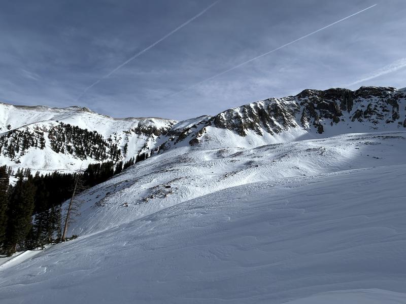
I took a trip up to alpine terrain yesterday. You can read my full report here. I found mostly hard-packed conditions due to strong winds over the weekend. Soft turns can be found on protected shady slopes near treeline and below where the surface snow continues to weaken and lose cohesion. Sluffs may run on the steepest slopes at these elevations. I am starting to gain enough confidence in the snowpack to travel up high, but I am avoiding the likely terrain features that can act as trigger points. There is still some concern for the buried persistent weak layer on the high northerlies, and human-triggered avalanches remain possible. Backcountry travelers must continue to evaluate the snow and terrain carefully to stay safe out there.
Snowpack and Weather Data
Gold Basin SNOTEL site (10,000')
SNOTEL site near Geyser Pass Winter Trailhead (9600')
Wind Station on Pre-Laurel Peak (11,400')
NWS forecast for the La Sal Mountains.
Alpine terrain is a mix of scoured surfaces and old, hard wind crusts. I'm looking for quality turns elsewhere.
Recent Avalanches
Ad
Avalanche Problem #1
Persistent Weak Layer
Type
Location
Likelihood
Size
Description
Poor snowpack structure remains, comprised of a dense slab over weak, faceted snow. In specific areas above treeline, the slab is cohesive enough to produce avalanches. The problem with basal facets is that even though it has been a long time since our last avalanche, you can still get surprised. All you need to do is find a trigger point. This is why we have a hard time trusting this setup. While the likelihood is decreasing, the bottom line is human-triggered avalanches remain possible. If triggered, these D2 avalanches will break to the ground, entraining the full depth of the snowpack. Likely trigger points include rocky, radical terrain, steep convexities, cliff bands, and shallow slope margins.
On some near treeline slopes, and many slopes below treeline, the slab has faceted through and has lost all cohesion. This is my strategy for quality turns, and to avoid today's avalanche problem.
Additional Information
Sign up for text alerts to get the most up to date information about changing conditions, road plowing, special avalanche announcements.
Follow us on Instagram @utavy_moab
General Announcements
This forecast is from the U.S.D.A. Forest Service, which is solely responsible for its content. This forecast describes general avalanche conditions and local variations always occur.