Forecast for the Moab Area Mountains

Eric Trenbeath
Issued by Eric Trenbeath for
Friday, December 14, 2018
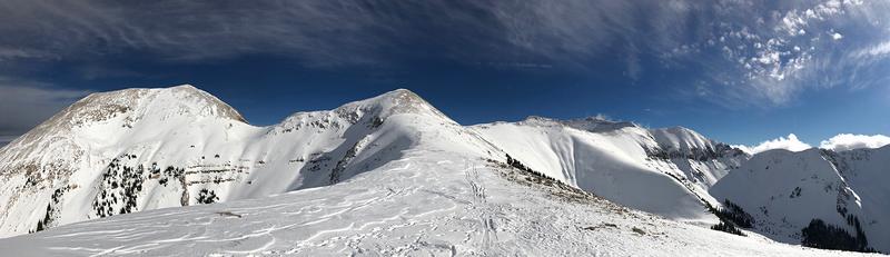
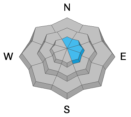
The avalanche danger is MODERATE on mid and upper elevation steep slopes that face NW-N-E, and human triggered avalanches breaking down into buried, persistent weak layers are still possible in these areas. The danger increases with elevation, and there is also a danger for triggering stiff slabs of recently deposited, wind drifted snow on slopes that face N-E-SE. Most S-SW facing terrain, and lower elevations have mostly LOW danger.
Low
Moderate
Considerable
High
Extreme
Learn how to read the forecast here
Special Announcements
Check out the new free online avalanche course series developed by the Utah Avalanche Center. This is a great way to refresh your skills or prepare you for a Backcountry 101 or Level 1 class.
Weather and Snow
Skies are clear, NW winds are light, and temps are in the low 20's. Daytime highs will be near 30 degrees with winds shifting to the SW. We may see a few high clouds this afternoon as a weak trough moves through the region. High pressure returns for the weekend with nothing out there on the horizon.
Wednesday's wind event put the final hurt on exposed snow surfaces and you'll have to work hard to find soft snow in sheltered locations. Low snow conditions still prevail as well with rocks and deadfall lurking just beneath the surface so be careful out there. Base depth in Gold Basin is 30".
Thanks to everyone for sending in observations! Check out the full list here.
New snow totals in Gold Basin (10,000')
Snow totals at the Geyser Pass Trailhead (9600')
Wind, temperature, and humidity on Pre Laurel Peak (11,700')
National Weather Service point forecast.
Recent Avalanches
In my travels yesterday I observed a few natural avalanches from the previous day's WNW wind event. Initiating from wind drifted snow, they appeared to have broken down into old weak layers with fractures 2'-3' deep, and up to 50' wide. These all occurred on E-NE facing slopes in the highest elevations.
Ad
Avalanche Problem #1
Persistent Weak Layer
Type
Location
Likelihood
Size
Description
Time heals, but persistent weak layers of loose, sugary, faceted snow remain in the snowpack. A layer of facets above a melt freeze crust is currently our most problematic weak layer, with snow from the 1st of December forming a cohesive slab on top. Faceted snow also exists below the crust, and in areas where the snowpack is shallow, faceted snow exists all the way to the ground. Stability tests show these layer to be less reactive and therefore trending toward a state of dormancy. I was however, still able to cause numerous, isolated collapses yesterday. This tells me that the snowpack is still unable to support my weight in many areas, and that is therefore still possible to trigger an avalanche. All you need to do is find the right trigger point in a rocky, shallow area, or above a hidden bush, and you could trigger an avalanche 2'-4' deep.
Avalanche Problem #2
Wind Drifted Snow
Type
Location
Likelihood
Size
Description
Wednesday's wind event created stiff slabs of wind drifted snow in the upper elevations, primarily on slopes with an easterly component. They'll be stubborn today, but a triggered wind slab has the potential to break down into buried, persistent weak layers causing a deep and dangerous avalanche. Avoid steep slopes and areas such as cross-loaded gullies that have a smooth rounded appearance, or where the snow feels hollow underneath.
General Announcements
Volunteers from LUNA were up grooming over the weekend and it's game on for Nordic skiing!