Forecast for the Moab Area Mountains

Eric Trenbeath
Issued by Eric Trenbeath for
Thursday, December 13, 2018
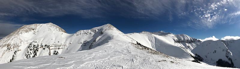
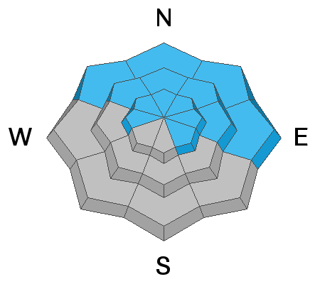
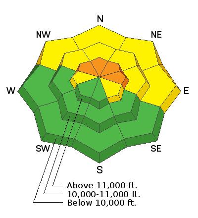
The avalanche danger is MODERATE on steep slopes that face NW-N-E, and dangerous, human triggered avalanches breaking down into buried, persistent weak layers are still very possible. The danger increases with elevation, and your safest bet is to continue to avoid steep, northerly facing terrain. Terrain on the south half of the compass has mostly LOW danger.
Low
Moderate
Considerable
High
Extreme
Learn how to read the forecast here
Special Announcements
I'll be giving a free Know Before You Go avalanche awareness presentation Tonight at 6:00 pm at the Grand County Library. Hope to see you there!
Also, check out the new free online avalanche course series developed by the Utah Avalanche Center. This is a great way to refresh your skills or prepare you for a Backcountry 101 or Level 1 class.
Weather and Snow
Skies are mostly clear now but we picked up a whopping 1" of snow in the early morning hours. WNW winds have been blowing heartily over the past 24 hours and are now averaging 15-20 mph. 10,000'' temps are frigid in the single digits. Today will be sunny and bone chilling with a continued blustery NW wind and high temps creeping up into the high teens. High pressure returns for the weekend with models diverging on the next system that is expected to impact the region Monday-Tuesday. Long term forecasts currently show a ridge building over the desert southwest by late next week.
It's now been 10 days since the last storm cycle, and wind and sun have taken their toll on exposed snow surfaces. You'll have to work harder to find soft snow in sheltered locations. It's still low snow conditions out there and rocks and deadfall lurk just beneath the surface so be careful out there. Base depth in Gold Basin is 30".
Thanks to all who have sent in observations this week! Check out the full list here.
New snow totals in Gold Basin (10,000')
Snow totals at the Geyser Pass Trailhead (9600')
Wind, temperature, and humidity on Pre Laurel Peak (11,700')
National Weather Service point forecast.
Recent Avalanches
It's been a week since we saw a round of natural activity when wind transported snow, from strong WSW winds, overloaded buried persistent weak layers, producing several avalanches up to 4' deep on N-E facing aspects.
Ad
Avalanche Problem #1
Persistent Weak Layer
Type
Location
Likelihood
Size
Description
Time heals, but persistent weak layers of loose, sugary, faceted snow remain in the snowpack. As recently as Monday, observers continued to report collapsing, and snowpits continue to reveal a poor snowpack structure. A layer of facets above a melt freeze crust in the middle of the pack is currently our most problematic weak layer, with last week's storm snow forming a cohesive slab on top. Beneath the crust, faceted snow also exists all the way to the ground. Though the likelihood of trigging an avalanche is decreasing over time, with a snowpack structure such as this, local observers and I will continue to avoid steep, northerly facing terrain for some time.
General Announcements
Volunteers from LUNA were up grooming over the weekend and it's game on for Nordic skiing!