Join us at our 2nd Annual Blizzard Ball

Forecast for the Moab Area Mountains

Eric Trenbeath
Issued by Eric Trenbeath on
Friday morning, December 10, 2021
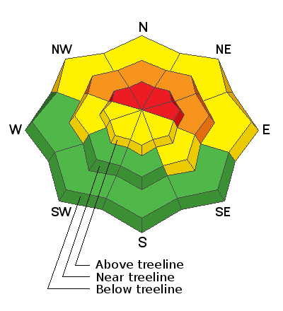
Heavy snowfall combined with wind has created a HIGH avalanche danger on steep, upper elevation terrain that faces NW through E. The danger is CONSIDERABLE at mid elevations on these same aspects. In these areas, new and wind drifted snow is sitting on top of older, weaker snow and human triggered avalanches are likely if not certain. Coverage remains quite thin and a ride in an avalanche would be brutal in these shallow snow conditions. The deep snow will make travel difficult today and lower angle slopes will be difficult to turn on. If you are hankering to get out and enjoy the new snow plan for a simple walk in the woods. The season is early, don't let your stoke get the best of you.
Low
Moderate
Considerable
High
Extreme
Learn how to read the forecast here
Special Announcements
Road Conditions: Grand County is working on getting a grader up today but timing is uncertain. The road will be closed while plowing is in progress.
Batteries for Beacons runs through Dec 19. Get free batteries for your transceiver and a chance to win 1 of 10 Black Diamond Rescue Kits, 1 of 3 Mammut Barryvox transceivers, or 1 of 3 BCA Tracker transceivers. Stop in at Moab Gear Trader, fill out our survey and get a free set of batteries. Don't need batteries, but still want a chance to win? Simply fill out the survey to be registered.
Weather and Snow
24 Hour Snow 19" 72 Hour Snow 21" Base Depth in Gold Basin 32" Wind NW 15-20 G40 Temp 15F
The storm came through much as promised with the Gold Basin SNOTEL site reporting 19" of new snow at almost 2.5" of SWE (Snow Water Equivalent). That's a significant load over a relatively short amount of time - snow didn't really start falling in earnest until after about 7:00 p.m. SW ridge top winds throughout the storm blew in the 15-25 mph range with gusts to 40. They've since swung around to the WNW. It's going to be frigid up there today with lingering clouds turning to partly sunny skies as the day progresses. High temps will be in the lower teens with blustery NW winds keeping wind chill values well below 0. Sunny skies and slight warming trend are on tap through the weekend with the next system developing around Tuesday.
Weather Links
BRAND NEW! Gold Basin SNOTEL site (10,000')
Ad
Avalanche Problem #1
Wind Drifted Snow
Type
Location
Likelihood
Size
Description
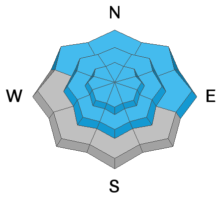
Blowing and drifting snow has created sensitive and dangerous drifts up to 2' deep or more on leeward, northerly facing slopes at mid and upper elevations. As winds shift to the NW, we'll see snow being transported on to more southerly aspects, especially at upper elevations. Avoid steep slopes that have recent deposits of wind drifted snow and look for signs of instability such as cracking in the snow surface.
Avalanche Problem #2
New Snow
Type
Location
Likelihood
Size
Description
Cohesive, soft slab avalanches within the new snow will be possible on all aspects today. The problem will be most pronounced on north facing slopes that had pre-existing snow cover but we may also see avalanches within the new snow on the southern half of the compass.
General Announcements
This forecast is from the U.S. Forest Service, which is solely responsible for its content. This forecast describes general avalanche conditions and local variations always occur.