Join us at our 2nd Annual Blizzard Ball

Forecast for the Moab Area Mountains

Eric Trenbeath
Issued by Eric Trenbeath on
Thursday morning, December 9, 2021
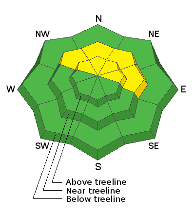
The avalanche danger will be on the increase over the next 24 hours as a strong storm system moves into our area. Today the avalanche danger is MODERATE but will likely reach CONSIDERABLE by this evening as new and wind drifted snow form dangerous slabs, primarily on steep, upper elevation, northerly facing slopes. Backcountry travelers need to be alert to changing conditions and avoid steep wind drifted slopes. A ride in an avalanche would be brutal in these shallow snow conditions. The overall snow cover is quite thin and travel is marginal with rocks, stumps, and deadfall posing serious additional hazards.
Low
Moderate
Considerable
High
Extreme
Learn how to read the forecast here
Special Announcements
It's Avalanche Awareness Week! For a schedule of events go HERE.
Our annual free Know Before You Go presentation is tonight, at 6:00 p.m. at the Moab Arts and Recreation Center, 111 E 100 N. Masks required.
Weather and Snow
Weather
A much anticipated, moisture laden storm system will move into our area today. Look for developing snow showers increasing in intensity this afternoon and lasting through the night. I'm thinking we'll see 12"-18" with 1.0" -1.5" of snow water equivalent (SWE). NWS is more optimistic with more than 2' of snow in the forecast. Lets hope they're right! SW winds will be on the increase blowing in the 15-25 mph range along ridge tops with gusts near 40. High temps at 10,000' will be in the mid 20's. After midnight, a cold front moves in and winds shift to the NW. We could see a few lingering showers Friday morning but the day looks mostly cold and dry with clearing skies by afternoon. Dry, cold, and clear conditions settle in over the weekend with the crystal ball showing another system out there next week.
Snowpack Discussion
Reports from the backcountry yesterday were of already developing, sensitive shallow wind drifts on upper elevation N-NE aspects. Though only a few inches deep, in areas of very steep terrain these wind slabs were sensitive to the weight of skiers and were running far and wide. Areas of wind drifted snow will become deeper and more widespread as the storm progresses.
After a moist October, which saw more than 2’ of snow fall in the mountains, November was mostly dry. Existing snow on northerly aspects ranges from about 10” at 10,000’ to 18” at upper elevations. Most sun exposed slopes have melted back to the ground and conditions are quite thin for over snow travel. And, as expected, this dry period has had a negative impact on snowpack structure. Surface snow has become either weak and sugary or slick and hard, and weak, faceted snow also exist deeper in the pack. Time and additional snow will determine how much of a problem this will be down the road.
Weather Links
BRAND NEW! Gold Basin SNOTEL site (10,000')
Ad
Avalanche Problem #1
Wind Drifted Snow
Type
Location
Likelihood
Size
Description
Sensitive areas of new and wind drifted snow will become deeper and more widespread as snow accumulates. Dangerous wind slabs will be most prevalent on steep, upper elevation northerly facing slopes that harbored pre-existing snow. A triggered avalanche may not bury you yet, but a ride over rocks would be brutal. Avoid steep, upper elevation, wind drifted slopes until the new snow has a chance to settle and adjust, and we have an opportunity to see how it reacts with the pre-existing snowpack.
General Announcements
This forecast is from the U.S. Forest Service, which is solely responsible for its content. This forecast describes general avalanche conditions and local variations always occur.