Forecast for the Moab Area Mountains

Eric Trenbeath
Issued by Eric Trenbeath for
Sunday, January 7, 2024
Heavy snowfall and strong winds will create dangerous avalanche conditions today!
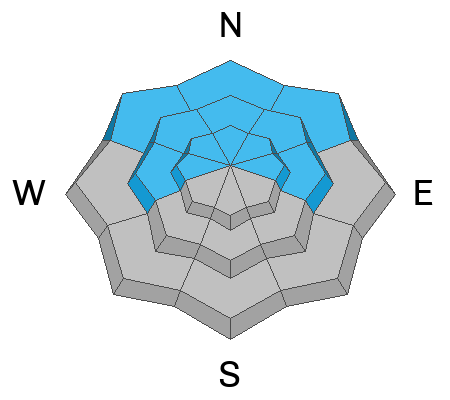
The avalanche danger will rise to CONSIDERABLE on all steep slopes near tree line and above. Human triggered avalanches are likely and natural avalanches are possible.
On northerly aspects, fresh slabs of new and wind drifted snow will begin to stress buried weak layers in the snowpack. Avalanches may be triggered from a distance and may break further and wider than expected.

Backcountry travelers need to have excellent route finding skills. Avoid slopes steeper than 30 degrees and avoid avalanche run out zones.

The snowpack is still very shallow and rocks, logs, and stumps remain a hazard right now.
Low
Moderate
Considerable
High
Extreme
Learn how to read the forecast here
Special Announcements
Sign up for forecast region-specific text message alerts. You will receive messages about changing avalanche conditions, watches, and warnings.
Follow us on Instagram @utavy_moab
Road Conditions: The road will not be plowed this morning and new and wind drifted snow will accumulate. 4x4 and good tires are required.
Grooming: A grooming schedule for the weekend is being assembled, check back for details.
Weather and Snow
6:00 a.m. Snow and Weather Data
24 Hour Snow 2" 72 Hour Snow 9" Season Total Snow 50" Base Depth at Gold Basin 30"
Winds on Pre-Laurel Peak: S 25-30 G 40 Temp 5˚ F

Weather
The snow has arrived a little late to the party but the winds have not. Expect increasing snowfall today as a low pressure system works its way through the Four Corners region. Up to a foot of snow is possible by nightfall. Winds from the SW will blow in the 20-25 mph range along ridgetops with gusts to 30. High temps will be in the mid-teens. Snow showers should linger overnight. Monday should see some clearing with frigid temperatures and blustery northerly winds. Another system tracking more to the north will move through on Wednesday, with unsettled weather through the remainder of the week.
General Conditions
It's about to be game on for skiing and riding but it's also game on for avalanches. In our travels yesterday we enjoyed 5"-7" of fresh, low density powder, but the underlying snow pack is very weak and largely unsupportable on northerly aspects. Overnight southerly winds have blown and drifted the recent snow into fresh slabs, further stressing buried weak layers. As new snow piles up, expect increasing danger on all aspects.
The new snow is about to change the landscape but conditions remain shallow. The unsupportable nature of the underlying snowpack will cause you to sink deep, especially with a machine. Continue to tread lightly out there.

Travis Nauman was up in Gold Basin yesterday and sent in this observation. For a list of all Moab observations go here.
Snowpack and Weather Data
Gold Basin Storm Stake (10,000')
Gold Basin SNOTEL site (10,000')
SNOTEL site near Geyser Pass Winter Trailhead (9600')
Wind Station on Pre-Laurel Peak (11,400')
NWS forecast for the La Sal Mountains.
Ad
Avalanche Problem #1
New Snow
Type
Location
Likelihood
Size
Description
Heavy snowfall today should cause the danger to rise on all aspects. Human triggered, sensitive soft slab avalanches within the new snow will become increasingly more likely as the day goes on. On northerly facing slopes, strong winds will drift snow into slabs 1'-2' deep. These drifts will be adding stress to buried weak layers in the snowpack increasing the likelihood for deeper and more dangerous avalanches on these aspects.
Avalanche Problem #2
Persistent Weak Layer
Type
Location
Likelihood
Size
Description
By now you know that we have a weak and deteriorating snowpack on northerly aspects with a variety of persistent weak layers. I expect the most active layer today will be the one closest to the top, but with most of the snowpack consisting of loose, sugary, facets, avalanches stepping down deeper are not out of the question. The stage has been set, and a load is being applied. Deep and dangerous, human triggered avalanches, failing on a buried persistent weak layer are likely.
Additional Information
To fulfill our mission, the UAC relies on our amazing backcountry community. Your support helps pay for the daily avalanche forecast, free awareness presentations across the state, and new tools like the new Avalanche and Observation Explorer. As we welcome the new year, please consider donating to the UAC.
General Announcements
This forecast is from the U.S.D.A. Forest Service, which is solely responsible for its content. This forecast describes general avalanche conditions and local variations always occur.