Forecast for the Moab Area Mountains

Eric Trenbeath
Issued by Eric Trenbeath for
Friday, January 5, 2024
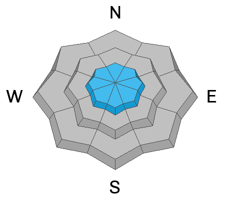
The avalanche danger is MODERATE on steep, upper elevation slopes around the compass. Human triggered avalanches involving slabs of recently deposited, wind drifted snow are possible. The avalanche danger is generally LOW outside of wind affected terrain.

The current snowpack is very weak. Anticipate dangerous conditions to develop as a series of storms begin to impact our area.

The snowpack is still very shallow and rocks, logs, and stumps remain a hazard right now.
Low
Moderate
Considerable
High
Extreme
Learn how to read the forecast here
Special Announcements
Sign up for forecast region-specific text message alerts. You will receive messages about changing avalanche conditions, watches, and warnings.
Follow us on Instagram @utavy_moab
Road Conditions: The road is plowed but the surface remains soft. AWD with good tires are required.
Grooming: A grooming schedule for the weekend is being assembled, check back for details.
Weather and Snow
6:00 a.m. Snow and Weather Data
24 Hour Snow 0" 72 Hour Snow 1" Season Total Snow 43" Base Depth at Gold Basin 24"
Winds on Pre-Laurel Peak: NW 10-15 Temp 9˚ F

Weather
We're in the grip of cold, northwest flow following the passage of yesterday's storm and mountain temps are in the single digits. We should see some clearing and a few sunny skies this morning. By this afternoon a weak shortwave moves through bringing a chance for a couple more inches of snow. NW winds will blow in the 10-15 mph range along ridge tops and high temps will be near 20F. A chance for showers remains overnight, with a break in the action on Saturday. By Sunday, a good looking storm tracking through the Four Corners region should be upon us.
General Conditions
Yesterday's northerly winds blew longer and stronger than I anticipated and they managed to whip an angry inch of new snow into fresh drifts 4"-6" deep. I expect this drifting to be spotty and not well connected, but there could be some surprises out there with slabs breaking farther and wider than expected. It's a complex landscape out there. The overall snowpack remains quite thin and of generally poor structure. Solar aspects are shallow, crusted, or bare. Northerly facing terrain is either weak and faceted through to the ground, or wind damaged. As new snow begins to pile up, we can expect avalanches to fail first at the old weak, snow surface. As a greater load accumulates, avalanches failing deeper into the snowpack will become increasingly more likely. See Dave's video below describing the current structure.
Snowpack and Weather Data
Gold Basin Storm Stake (10,000')
Gold Basin SNOTEL site (10,000')
SNOTEL site near Geyser Pass Winter Trailhead (9600')
Wind Station on Pre-Laurel Peak (11,400')
NWS forecast for the La Sal Mountains.
Ad
Avalanche Problem #1
Wind Drifted Snow
Type
Location
Likelihood
Size
Description
Shallow soft slabs of wind drifted snow have developed as a result of yesterday's winds and meager snowfall amounts. Look for fresh slabs of wind drifted snow on the leeward sides of ridge crests and terrain features such as gully walls and subridges. You should be able to recognize them by their smooth, rounded appearance, and cracking is a sign of instability.
As new and wind drifted snow accumulates through the next series of storm systems, expect slabs to become deeper and more widespread. As the load increases, slabs will invariably begin to stress the underlying, weak snowpack, and deeper avalanches involving persistent weak layers will become increasingly more likely.
Additional Information
To fulfill our mission, the UAC relies on our amazing backcountry community. Your support helps pay for the daily avalanche forecast, free awareness presentations across the state, and new tools like the new Avalanche and Observation Explorer. As we welcome the new year, please consider donating to the UAC.
General Announcements
This forecast is from the U.S.D.A. Forest Service, which is solely responsible for its content. This forecast describes general avalanche conditions and local variations always occur.