Forecast for the Moab Area Mountains

Eric Trenbeath
Issued by Eric Trenbeath for
Friday, January 4, 2019
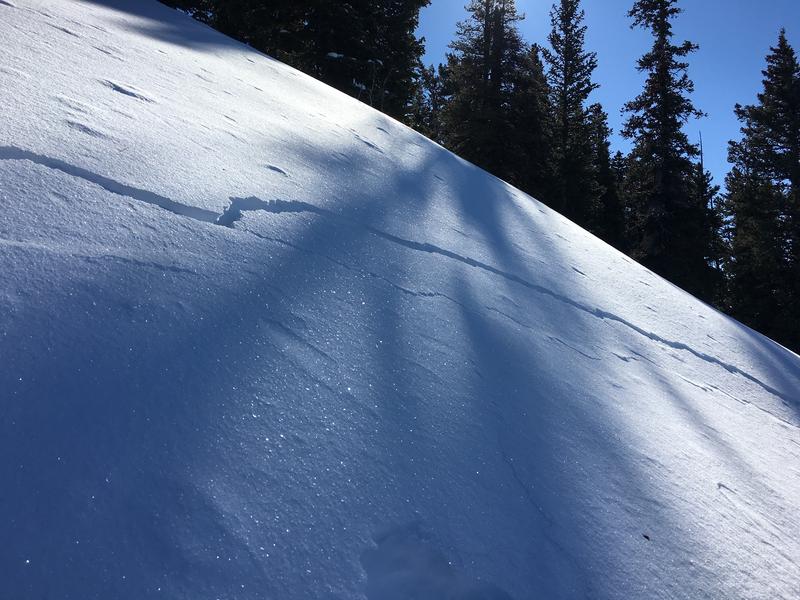
The avalanche danger is MODERATE on steep slopes that have recent deposits of wind drifted snow. Avoid slopes with a smooth rounded appearance or that show signs of instability such as cracking in the snow surface. There also remains an isolated, or MODERATE danger for avalanches stepping down 2'-4' deep into buried, persistent weak layers of loose, sugary, faceted snow. Northerly facing slopes with steep, rocky, and more radical terrain are the most suspect for this type of avalanche.
Low
Moderate
Considerable
High
Extreme
Learn how to read the forecast here
Special Announcements
We will be offering a Backcountry 101 avalanche course on Feb 8, 9. It's a great way to up your avalanche knowledge with both classroom, and hands on field instruction. Click here for more details and to register.
The new UAC IOS mobile app is now available on the app store. Check out the new "My Weather" feature.
Check out the new free online avalanche course series developed by the Utah Avalanche Center. This is a great way to refresh your skills or prepare you for a Backcountry 101 or Level 1 class.
Weather and Snow
Skies are clear, ridge top westerly winds are averaging 10-15 mph, and 10,000' temps are in the low 20's. Today will be a beautiful day in the mountains with sunny skies, light WSW winds, and temps in the high 20's. Tomorrow we'll see clouds begin to move into the area ahead of storm system on Sunday that looks like it may give us a decent shot of snow.
Winds throughout the week have wreaked a bit of havoc on the snow surface in exposed terrain, but I'm still getting reports of decent settled powder in sheltered terrain.
Maggie Nielsen was out and about yesterday and sent in this observation.
New snow totals in Gold Basin (10,000')
Snow totals at the Geyser Pass Trailhead (9600')
Wind, temperature, and humidity on Pre Laurel Peak (11,700')
National Weather Service point forecast.
Recent Avalanches
No recent avalanche activity to report.
Ad
Avalanche Problem #1
Wind Drifted Snow
Type
Location
Likelihood
Size
Description
Winds have been erratic and forceful throughout the week. A northeasterly component has been dominant and though it's been three days since the most recent snowfall, fresh, unstable deposits of wind drifted snow are still being reported. Continue to be on the lookout for newly formed wind slabs. Avoid slopes with a smooth rounded appearance, or that show signs of instability such as cracking in the snow surface.
Dave Garcia sent in this pic of cracking in wind drifted snow that he observed yesterday, on a westerly aspect around 10,500'.
Avalanche Problem #2
Persistent Weak Layer
Type
Location
Likelihood
Size
Description
With our poor snowpack structure, the possibility remains for triggering an avalanche on a buried persistent weak layer of loose, sugary, faceted snow. This is primarily a low probability, but high consequence situation where a triggered avalanches could release between 2'-4' deep. The danger is most acute in areas of steep, rocky, north facing terrain that has a weak, sugary, underlying snowpack, and I'm going to continue to avoid those areas.
Additional Information
Matt Hebberd from the Lower Utah Nordic Alliance (LUNA) was up yesterday and groomed all trails with classic track from Gold Basin to Geyser Pass. Thanks Matt!
General Announcements
Your information can save lives. If you see anything we should know about, please help us out by submitting snow and avalanche observations HERE. You can also call me at 801-647-8896, or send me an email: [email protected].
Support the UAC through your daily shopping. When you shop at Smith's, or online at REI, Backcountry.com, Patagonia, NRS, Amazon, eBay by clicking on these links, they donate a portion of your purchase to the UAC. If you sell on eBay, you can have your See our Affiliate Page for more details on how you can support the UAC when you shop
This advisory is from the U.S.D.A. Forest Service, which is solely responsible for its content. This advisory describes general avalanche conditions and local variations always occur.