Join us for the 33rd Backcountry Benefit - Get Your Tickets Now!

Forecast for the Moab Area Mountains

Dave Garcia
Issued by Dave Garcia on
Wednesday morning, January 28, 2026

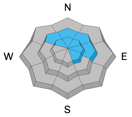
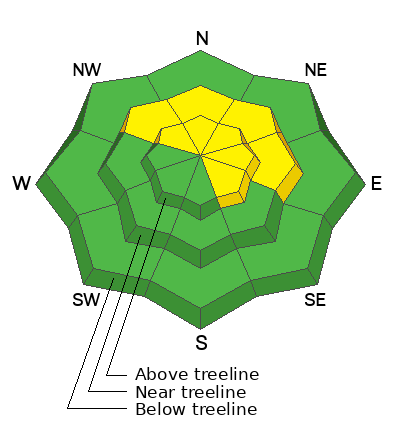
The avalanche danger is MODERATE on steep slopes near and above treeline facing northwest through east, and on southeast-facing slopes above treeline. Human-triggered avalanches failing on a persistent weak layer are POSSIBLE. Steep slopes that have seen previous drifting are bulls-eye terrain for this problem.

Avalanches may initially break up to two feet deep, but could step down into deeper weak layers and take out the entire season’s snowpack. These avalanches would be large and dangerous. The most effective way to avoid this problem is to stay off slopes steeper than 30 degrees.

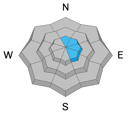
In isolated areas above treeline, it is still possible to trigger slabs of wind-drifted snow. These avalanches could push you into trees or over cliffs, or step down to more deeply buried persistent weak layers.
Low
Moderate
Considerable
High
Extreme
Learn how to read the forecast here
Special Announcements

Geyser Pass Road Conditions: The road was plowed yesterday, thanks Grand County! It remains slick and snowpacked; 4x4 and good tires are recommended.

Grooming: Trails have seen a lot of traffic and are not freshly groomed.

We are looking to reschedule our Moab Backcountry 101 Class to February 20, 21 in the hopes that we will have more snow. Click here for information and registration. Moab and Monticello locals can use the discount code MOAB-LOCAL for a 10% discount.

Weather and Snow

24 Hour Snow: 0" 72 Hour Snow: 0" Season Total Snow: 44" Depth at Gold Basin: 28"

Winds on Pre-Laurel Peak: WSW 10 G 15 Temp: 15°F

Weather

Under scattered clouds, it is 15°F in Gold Basin this morning. Yesterday, light winds blew from the northwest. Winds shifted direction around midnight, and are light out of the west-southwest. Today will be mostly sunny with highs at 10,000 feet around 27°F. Winds will blow out of the southwest in the 10-20 MPH range. For the rest of the week, we can expect warm days, cool nights, and dry weather. By the weekend, temperatures will reach the mid-30s°F. A pattern change is possible by early next week.

General Conditions

The mountains received 10 inches of snow on Friday and Saturday. Strong winds from the northwest on Sunday put a slight damper on the powder party, but there is still plenty of soft snow out there. You just have to put a bit of work in to sniff out the good turns. Northerly aspects are heavily wind-damaged in some drainages, while they remain unaffected in other drainages. I was up with Evan and Tim yesterday, and we found fun riding on west faces near treeline. Southerly aspects took on a lot of solar input yesterday, and may be crusted over this morning.

There are two avalanche problems to look out for today. First, you can still trigger a lingering wind drift above treeline. Second, it remains possible for skiers and riders to trigger deep and dangerous avalanches failing on a persistent weak layer. The snowpack on northerly facing slopes has several layers of weak faceted snow beneath previously drifted snow that can fail beneath the weight of a skier or snow machine.

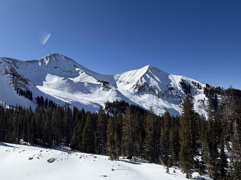
Zoom in on this photo to see extensive wind damage in Red Snow Cirque and Middle Cirque.

See more recent observations here.

Snowpack and Weather Data

Gold Basin SNOTEL site (10,000')
SNOTEL site near Geyser Pass Winter Trailhead (9600')
Wind Station on Pre-Laurel Peak (11,400')
NWS forecast for the La Sal Mountains.
Recent Avalanches
The weekend storm produced a decent round of natural activity, including dry loose, soft slab, and hard slab avalanches. We have been getting around the past few days and viewing the recent activity. The avalanche database is updated with the latest info and can be viewed here.
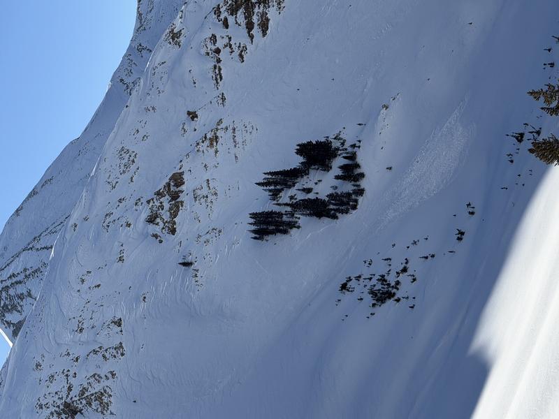
Not recent, but this wind slab avalanche resulted from strong winds from the northwest on Saturday and Sunday.
Avalanche Problem #1
Persistent Weak Layer
Type
Location
Likelihood
Size
Description

Several layers of faceted snow exist within the snowpack. The most recently buried weak layer is a layer of near-surface facets now sitting beneath the new snow. This layer is likely sensitive to the weight of a person and may be the first place an avalanche fails. Avalanches that start here can step down into deeper, more problematic persistent weak layers both above and below the Christmas rain crust. Avalanches can also initiate on these more deeply buried layers.

Any avalanche that fails below the crust would be large and dangerous, potentially breaking to the ground and taking out the entire season’s snowpack. In many areas near treeline and below, the snowpack remains faceted top to bottom and lacks a cohesive slab. Where a slab does exist, the snowpack structure is poor.

You may not experience cracking or collapsing today. The key is to look for signs of strong snow over weak snow—hard snow over soft snow. If you find a slab, carefully evaluate that slope or avoid it altogether. This problem is most pronounced on north and east-facing slopes, but it also exists on northwest and southeast-facing aspects.

Avalanche Problem #2
Wind Drifted Snow
Type
Location
Likelihood
Size
Description

While becoming less likely, I bet you can still find a lingering drift that could react to the weight of a skier or rider. If you are traveling above treeline today, the extent of wind-drifted snow is obvious and impressive. You will want to avoid any slopes that look fat, round, and pillowy. These old hard slabs will sound hollow like a drum beneath your skis or board. Hard slab of wind-drifted snow are tricky, because they allow the rider to get far out on to them before they break.

Additional Information
General Announcements
This forecast is from the U.S.D.A. Forest Service, which is solely responsible for its content. This forecast describes general avalanche conditions and local variations always occur.