AVALANCHE WARNING!! Tap for info
UDOT PLANNED AVALANCHE CLOSURES!!

Forecast for the Moab Area Mountains

Eric Trenbeath
Issued by Eric Trenbeath on
Monday morning, January 27, 2025
The avalanche danger is generally LOW and human triggered avalanches are unlikely. Low danger doesn't mean no danger and mountain travel in winter nearly always retains some risk for avalanches. Northerly facing slopes carry the highest risk. Near treeline, isolated slabs of drifted snow remain over weak facted layers. Minimize your risk by continuing to avoid natural trigger points such as steep convexities, and very steep, rocky, radical terrain.
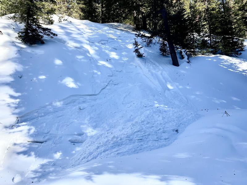
Small, loose, dry avalanches are possible on very steep, sheltered, northerly facing terrain below treeline. Although not large enough to bury you, they could sweep you off your feet and take you for a ride.
Low
Moderate
Considerable
High
Extreme
Learn how to read the forecast here
Special Announcements
Urgent battery replacement required for anyone who received batteries from one of our participating "Batteries for Beacons" shops. Please review the "Batteries for Beacons" replacement notice on our blog. Batteries distributed through our "Batteries for Beacons" program this year have shown to be inadequate length.
Geyser Pass Road: Surface is mainly snowpacked and icy above and bare dirt down low. AWD with good tires recommended.
Grooming Conditions: LUNA is unfortunately experiencing a lack of available groomers this season and trails have not been groomed for more than a week.
Weather and Snow
6 A.M. Snow and Weather Data
24 Hour Snow: 0" 72 Hour Snow: 0" Season Total Snow: 63" Depth at Gold Basin: 29"
Winds on Pre-Laurel Peak: SE 15-20 G 26 Temp: 20° F Percent of Normal (SWE): 79%
Weather
Look for mostly sunny skies this morning with increasing clouds later today as a closed low approaches the Four Corners. Winds will be mostly light to moderate from the southeast with higher speeds along ridge tops. High temperatures at 10,000' will be around 30°F. A chance for snow develops tonight and lasting through Thursday as the low pressure system stalls out over the region. In spite of the long duration, we aren't likely to see much from this. High pressure and warmer temperatures return for the weekend. The long range Kool-Aid is already being diluted, and it looks like we'll be at least a week into February before we get another chance for snow.
General Conditions
The current snowpack is weak and faceted, variable in depth, and contains a smattering of old, hard wind slabs. Above treeline, the snow surface has been severely affected by the wind and many slopes are scoured down to the rocks. On shady slopes below treeline the snowpack is entirely faceted and has lost all cohesion. Small, loose, dry, "facet-lanches" are possible to likely on very steep slopes. The good news is, there is still enough snow for travel and we'll be back in business if the pattern ever changes. The bad news is, conditions will quickly become dangerous again when new snow finally comes.
General conditions above treeline:
Small, loose, "facet-lanche" on a steep gully wall below treeline:
Snowpack and Weather Data
Gold Basin SNOTEL site (10,000')
SNOTEL site near Geyser Pass Winter Trailhead (9600')
Wind Station on Pre-Laurel Peak (11,400')
NWS forecast for the La Sal Mountains.
Recent Avalanches
Ad
Avalanche Problem #1
Normal Caution
Type
Location
Likelihood
Size
Description
As I said above, low danger doesn't mean no danger and mountain travel is inherently risky. And, unlike late season low danger, when the snowpack is generally deep and strong, the current snowpack is thin, variable, and weak. It's been over three weeks, however, since we've received any significant snow, and even longer since we had any widespread significant avalanche activity, and it's our conclusion that conditions are generally stable. Nevertheless, here are a few things to keep in mind, and although none of these concerns are widespread, there may be isolated situations that could get you into trouble.
  • Persistent Weak Layer - If you've been following along, you know we've been tracking faceted persistent weak layers both at the base of the snowpack, and closer to the surface. Stability tests have been non-reactive for some time and it's our conclusion that these weak layers are currently dormant. They are still there, however, and it might be possible to run across the right combination of slab over weak layer and trigger an avalanche. Areas where you may find this combination are on steep, northerly aspects near treeline. You can give yourself a margin of safety by avoiding steep convexities, thin, shallow rocky areas, and areas of extreme terrain.
  • Wind Drifted Snow - The La Sals are a high, islolated, wind swept mountain range and snow is often transported and then deposited as slabs of wind drifted snow. The current threat is isolated to specific terrain features and avalanches will be small, but they could sweep you off your feet and carry you over a cliff in the wrong location. Remain cautious of smooth, rounded, hollow feeling, areas, especially when in consequential terrain.
  • Loose Dry Avalanches - Below treeline on northerly aspects, the snowpack is entirely loose and faceted. You can trigger small avalanches in very steep terrain. These slides would not be large enough to bury you, but they could sweep you off your feet and carry you into a tree or over a cliff.
Additional Information
Sign up for text alerts to get the most up to date information about changing conditions, road plowing, special avalanche announcements.
Follow us on Instagram @utavy_moab
General Announcements
This forecast is from the U.S.D.A. Forest Service, which is solely responsible for its content. This forecast describes general avalanche conditions and local variations always occur.