AVALANCHE WARNING!! Tap for info
UDOT PLANNED AVALANCHE CLOSURES!!

Forecast for the Moab Area Mountains

Dave Garcia
Issued by Dave Garcia on
Tuesday morning, January 28, 2025
The overall danger is LOW and generally safe avalanche conditions exist. Watch for unstable snow in outlying areas. Human-triggered avalanches are unlikely, but small avalanches remain possible in isolated areas or extreme terrain. Steep northerly facing slopes carry the highest risk.
Low
Moderate
Considerable
High
Extreme
Learn how to read the forecast here
Special Announcements
Urgent battery replacement required for anyone who received batteries from one of our participating "Batteries for Beacons" shops. Please review the "Batteries for Beacons" replacement notice on our blog. Batteries distributed through our "Batteries for Beacons" program this year have shown to be inadequate length.
Geyser Pass Road: Surface is mainly snowpacked and icy above and bare dirt down low. AWD with good tires recommended.
Grooming Conditions: LUNA is unfortunately experiencing a lack of available groomers this season and trails have not been groomed for more than a week.
Weather and Snow
6 A.M. Snow and Weather Data
24 Hour Snow: 0" 72 Hour Snow: 0" Season Total Snow: 63" Depth at Gold Basin: 29"
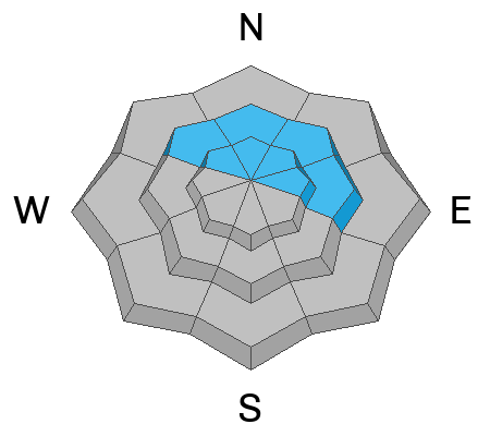
Winds on Pre-Laurel Peak: 11-16 SE Temp: 21° F Percent of Normal (SWE): 73%
Weather
Under clear skies this morning, it is 21° F in Gold Basin. Overnight winds started out light from the north and shifted to the southeast. Light winds will remain southeasterly, and high temperatures will reach 26° F under scattered clouds. Cloud cover will increase tonight, with a 40% chance of snow showers after 4 AM. A closed low is currently stalled out over central Arizona. On Wednesday morning the low will push to the east, bringing a decent chance for snow in the southwest San Juan Range. The La Sals will see isolated snow showers throughout the day on Wednesday. Confidence is low, but we should see some amount of measurable snowfall. High pressure returns to southeast Utah later this week.
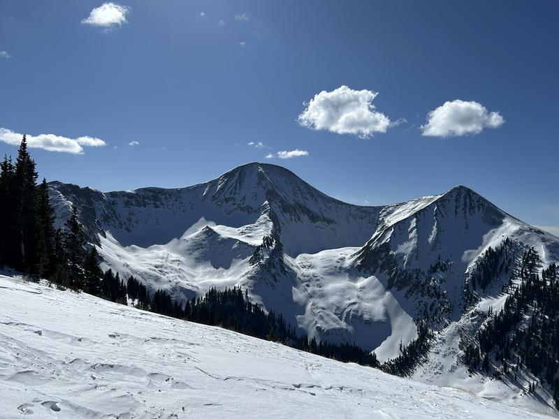
General Conditions
I traveled around Gold Basin yesterday, and you can read my report here. It's no secret that conditions are pretty rough out there, and we definitely need some snow. It's getting hard to find any soft turns. Low avalanche danger and generally stable conditions are great for getting up high and taking in some views, just as long as you have low standards for the ski back down. Above treeline terrain is generally very hard and wind blasted. Near treeline and below is a mix of variable, and somewhat grabby conditions.
The overall snowpack is weak in many places. When it does snow again, we will see the avalanche danger rise quickly. For now, continue to look for weak surface snow near the treeline and below, which can result in small dry-loose avalanches on very steep slopes. If you're getting up high, you may encounter old shallow drifts that may still be sensitive to the weight of a skier or rider.
Snowpack and Weather Data
Gold Basin SNOTEL site (10,000')
SNOTEL site near Geyser Pass Winter Trailhead (9600')
Wind Station on Pre-Laurel Peak (11,400')
NWS forecast for the La Sal Mountains.
Recent Avalanches
Ad
Avalanche Problem #1
Normal Caution
Type
Location
Likelihood
Size
Description
The avalanche danger is low and conditions are generally stable. Here are a few things to keep in mind as you travel through the backcountry today.
  • Persistent Weak Layer - Our snowpack is generally weak and faceted in many areas. This is different than your typical late-season low danger. If you are getting into big lines and steep terrain, it is always wise to evaluate the snowpack first. Look for slabs over weak layers. Reduce your risk by avoiding likely trigger points like shallow rocky areas, steep convexities, and thin slab margins.
  • Wind Drifted Snow - The La Sals are a high, islolated, wind swept mountain range and snow is often transported and then deposited as slabs of wind drifted snow. The current threat is isolated to specific terrain features and avalanches will be small, but they could sweep you off your feet and carry you over a cliff in the wrong location. Remain cautious of smooth, rounded, hollow feeling, areas, especially when in consequential terrain.
  • Loose Dry Avalanches - Below treeline on northerly aspects, the snowpack is entirely loose and faceted. You can trigger small dry-loose avalanches in very steep terrain. These slides would not be large enough to bury you, but they could sweep you off your feet and carry you into a tree or over a cliff.
Additional Information
Sign up for text alerts to get the most up to date information about changing conditions, road plowing, special avalanche announcements.
Follow us on Instagram @utavy_moab
General Announcements
This forecast is from the U.S.D.A. Forest Service, which is solely responsible for its content. This forecast describes general avalanche conditions and local variations always occur.