Forecast for the Moab Area Mountains

Dave Garcia
Issued by Dave Garcia for
Tuesday, January 23, 2024
A CONSIDERABLE avalanche danger remains on steep slopes facing W-N-E at all elevations. Skiers and riders are LIKELY to trigger avalanches breaking 2 feet deep or more. These are dangerous avalanche conditions that require conservative decision making.
A MODERATE avalanche danger exists on steep slopes facing SW-S-SE at all elevations. Signs of instability will be less obvious on these slopes, but human-triggered avalanches failing on a buried persistent weak layer remain possible.

Fortunately, the snow quality is great and skiing and riding on low angle slopes is your ticket to a good time in the mountains today.
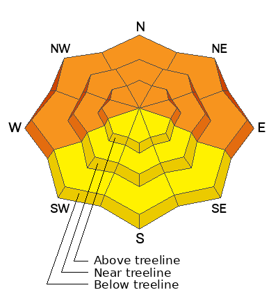
Low
Moderate
Considerable
High
Extreme
Learn how to read the forecast here
Special Announcements
Road Conditions: The Geyser Pass Road was plowed on Monday. The road remains snow covered and AWD and good tires are recommended.
Grooming: LUNA rolled out Gold Basin through Geyser Pass on Sunday.
A huge shout out to those who participated in our Backcountry 101 class! And thanks to Moab Gear Trader for their generous sponsorship!
Weather and Snow
6:00 a.m. Snow and Weather Data
24 Hour Snow 1" 72 Hour Snow 8" Season Total Snow 90" Base Depth at Gold Basin 41"
Winds on Pre-Laurel Peak: SSE 7 G 11 Temp 25˚ F

Weather
Cloud cover will be on the increase today, with maybe a few stray snow showers. No accumulation is expected. Winds will continue to behave themselves and will blow out of the SSE at 5-10 mph. High temperatures will reach the upper 20's today. Temperatures remain mild through the forecast period this week. The next trough impacts the La Sals on Thursday. Snowfall totals don't look impressive, but it should be another nice refresh to the snow surface. Sunshine returns for Friday and Saturday.
General Conditions
A couple more inches trickled in, and we have received 8 inches in Gold Basin in the past 72 hours. Riding conditions are great, the new snow is creamy, medium-density pow. Winds have been well behaved and the sun did not come out yesterday, so all aspects are riding nicely. The snowpack is starting to feel supportive under our skis, which has really helped skiing conditions. But step off your skis or board, and foot penetration is still almost to the ground, especially on Northerly aspects. This tells us the underlying snowpack is still quite weak. Yesterday I continued to experience red flags of instability like collapsing of the snowpack and shooting cracks. Another backcountry party reported the same. The snowpack is telling us to exercise patience and avoid steep slopes for the time being.
To see a report of my travels from yesterday click here.
Snowpack and Weather Data
Gold Basin Storm Stake (10,000')
Gold Basin SNOTEL site (10,000')
SNOTEL site near Geyser Pass Winter Trailhead (9600')
Wind Station on Pre-Laurel Peak (11,400')
NWS forecast for the La Sal Mountains.
Ad
Avalanche Problem #1
Persistent Weak Layer
Type
Location
Likelihood
Size
Description
The most recent storm dropped 8 inches of snow and 1.2” of water on Sunday and Monday. We refer to this as incremental loading of our snowpack. It is not a big sudden load that will bring the house down, but it is enough of a load to keep the danger elevated. Backcountry observers continue to experience cracking and collapsing on Northerly aspects. The suspect weak layer is buried about 2 feet below the snow surface, and is easily observed in snow pits.
This instability is not limited to Northerly aspects. Southerly aspects have poor snowpack structure, and we are still seeing poor results in stability tests. You may not experience collapsing on these slopes, but it remains possible for riders to trigger avalanches up to two feet deep.
The strategic mind-set for now, is entrenchment. We are dealing with a well-established persistent weak layer and it simply needs more time to stabilize. Dealing with a weakness like this requires patience and the strategy remains avoiding slopes that are steeper than 30 degrees.
The weak layer is easily observed roughly 2 feet down.
Additional Information
Sign up for forecast region-specific text message alerts. You will receive messages about changing avalanche conditions, watches, warnings and road plowing closures.
Follow us on Instagram @utavy_moab
To fulfill our mission, the UAC relies on our amazing backcountry community. Your support helps pay for the daily avalanche forecast, free awareness presentations across the state, and new tools like the new Avalanche and Observation Explorer. As we welcome the new year, please consider donating to the UAC.
General Announcements
This forecast is from the U.S.D.A. Forest Service, which is solely responsible for its content. This forecast describes general avalanche conditions and local variations always occur.