Join us at our 2nd Annual Blizzard Ball

Forecast for the Moab Area Mountains

Eric Trenbeath
Issued by Eric Trenbeath on
Monday morning, January 22, 2024
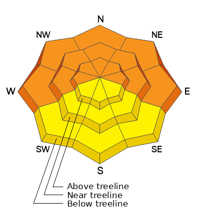
A CONSIDERABLE avalanche danger remains on steep slopes facing W-N-E at all elevations. Deep and dangerous human triggered avalanches involving a buried persistent weak layer are likely in these areas.
A MODERATE avalanche danger exists on steep slopes facing SW-S-SE at all elevations. Human triggered avalanches failing on a buried persistent weak layer are possible.

A very weak, and unstable snowpack has developed and this situation is likely to be with us for awhile. Cultivate the mindset that avalanche terrain is off limits and keep your slope angles less than 30 degrees.
Low
Moderate
Considerable
High
Extreme
Learn how to read the forecast here
Special Announcements
Road Conditions: The Geyser Pass Road will be closed for plowing this morning.
Grooming: LUNA rolled out Gold Basin through Geyser Pass yesterday.
A huge shout out to those who participated in our Backcountry 101 class! And thanks to Moab Gear Trader for their generous sponsorship!
Weather and Snow
6:00 a.m. Snow and Weather Data
24 Hour Snow 5" 72 Hour Snow 7" Season Total Snow 88" Base Depth at Gold Basin 41"
Winds on Pre-Laurel Peak: S 5-15 Temp 26˚ F

Weather
We remain under the influence of southwest flow and a broad low pressure system moving to the east. Today look for light snow showers, primarily this morning, with 2"-4" possible. Winds from the SW will be light, and high temps at 10,000' will be in the upper 20's.
General Conditions
The storm yesterday over delivered and we received 6" of fairly dense new snow at 0.8" of Snow Water Equivalent (SWE). The new snow fell without wind and conditions should be great today. Although 0.8 SWE isn't a lot of weight, it's yet another incremental load on our fragile snowpack. We have a widespread persistent weak layer with an over-riding slab on all aspects and elevations. Collapsing or whumphing is becoming less widespread but it is still happening. This red flag sign of instability is the slab failing under a person's weight. The danger is greatest on steep, wind loaded, northerly aspects right around treeline, but avoiding slopes steeper than 30 degrees on all aspects remains the only guaranteed safe strategy right now.
Check out this video where Backcountry 101 students got to experience first hand the signs of an unstable snowpack:
Snowpack and Weather Data
Gold Basin Storm Stake (10,000')
Gold Basin SNOTEL site (10,000')
SNOTEL site near Geyser Pass Winter Trailhead (9600')
Wind Station on Pre-Laurel Peak (11,400')
NWS forecast for the La Sal Mountains.
Recent Avalanches
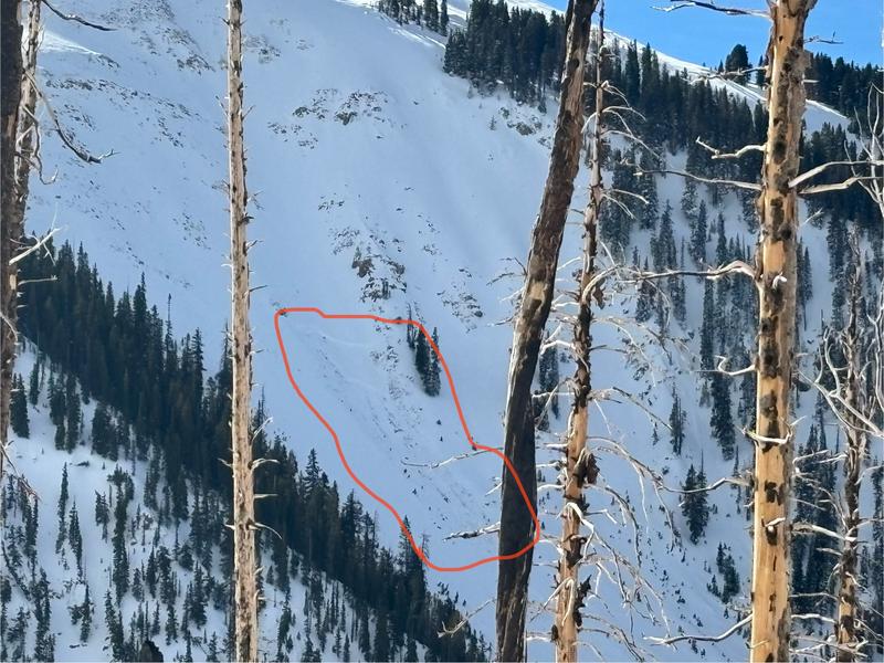
Reports of natural activity continue to trickle in. Natural slides likely occurred last Sunday or Monday. The photo below from Sam Van Wetter shows an avalanche on a due north aspect at a fairly low elevation of around 10,400'. From the looks of it, it failed on the December Drought layer before stepping down to weak facets near the ground. Avalanches such as this remain primed for a human trigger.
Ad
Avalanche Problem #1
Persistent Weak Layer
Type
Location
Likelihood
Size
Description
A slab of cohesive snow now exists above a persistent weak layer of faceted snow on all aspects and elevations. On northerly facing slopes, thick hard slabs of wind-drifted snow rest on top of this weak layer and they are hanging in the balance just waiting for a trigger. Once triggered, these avalanches will break deep and wide, and will be un-survivable. On southerly aspects stability tests also demonstrate slab failure with propagation. This is unusual for us. These avalanches are more stubborn to trigger, and won't be quite as large, but make no mistake, they are not to be trifled with. Avoidance of slopes steeper than 30 degrees is the only safe strategy right now.
The video below illustrates unstable conditions with a slab failing on a weak layer on a SE aspect. An extended column test produced results of ECTP23.
Additional Information
Sign up for forecast region-specific text message alerts. You will receive messages about changing avalanche conditions, watches, warnings and road plowing closures.
Follow us on Instagram @utavy_moab
To fulfill our mission, the UAC relies on our amazing backcountry community. Your support helps pay for the daily avalanche forecast, free awareness presentations across the state, and new tools like the new Avalanche and Observation Explorer. As we welcome the new year, please consider donating to the UAC.
General Announcements
This forecast is from the U.S.D.A. Forest Service, which is solely responsible for its content. This forecast describes general avalanche conditions and local variations always occur.