Join us at our 2nd Annual Blizzard Ball

Forecast for the Moab Area Mountains

Dave Garcia
Issued by Dave Garcia on
Wednesday morning, January 22, 2025
With strong winds out of the northwest, and recent snow available for transport, there is a MODERATE danger of triggering an avalanche in wind drifted snow on all aspects near treeline and above.
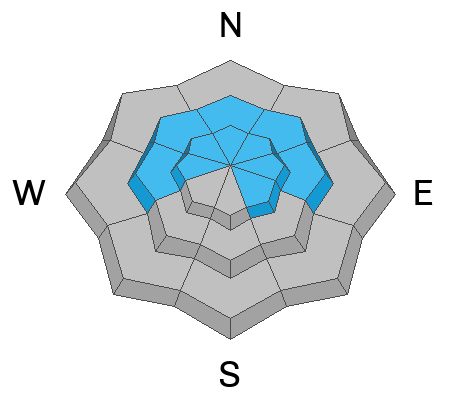
Near treeline, it is still possible to trigger an avalanche 1-2 feet deep on a weak layer of buried facets. Blowing and drifting snow will add stress to this weak layer. This problem is most pronounced on slopes that face W-N-E.
Low
Moderate
Considerable
High
Extreme
Learn how to read the forecast here
Special Announcements
Geyser Pass Road: Surface is mainly snowpacked and icy. AWD with good tires required.
Grooming Conditions: Gold Basin through Geyser Pass was groomed Saturday.
The beacon park is up and running. High pressure is a great time to work on your beacon skills.
Weather and Snow
6 A.M. Snow and Weather Data
24 Hour Snow: 0" 72 Hour Snow: 0" Season Total Snow: 63" Depth at Gold Basin: 30"
Winds on Pre-Laurel Peak: NW 38-44 Temp: 12° F Percent of Normal (SWE): 80%
Weather
This morning, under clear skies, temperatures have warmed slightly and it is 12° F in Gold Basin at 6 AM. Winds from the northwest have been blowing in the moderate to strong range overnight with the highest gusts up to 44 MPH. High temperatures will reach 14° F today, northwest winds will remain elevated, averaging in the 20s MPH with gusts up to the low 40s MPH. The wind chill will make it feel very cold out there today, at least the skies will be sunny. Sunshine stays with us through Friday, and temperatures will climb into the low 20s. The overall pattern starts to become more active this weekend, and our next chance for snow is Saturday into Sunday.
General Conditions
Slopes above 10,000 feet have received three inches of low-density snow since Saturday. This small amount of new snow will slightly improve riding conditions, but the latest round of wind will make things a little rough out there. Above treeline, the new snow seems to have blown away, and you will find a variety of hard wind-scoured surfaces and sastrugi, with alternately loaded depressions and gullies. These alpine zones previously were heavily scoured and the chances of triggering a deep avalanche failing on facets are unlikely. Your primary avalanche concern today is wind-drifted snow. Northwest winds have been blowing and drifting snow since Monday, and show no signs of stopping. Winds from the northwest tend to load a variety of aspects. Look for fresh pillows of wind-drifted snow just below ridge lines and on the lee side of mid-slope terrain features.
There is still some concern regarding the weak layer that was buried on 12/25. This layer remains sensitive anywhere there is a cohesive slab on top. The recent winds will form fresh slabs above this weak layer, and increase the distribution of this problem. We have found this layer to be the most prominent near treeline. Skiers and riders must continue to look for this potentially unstable slab/weak layer combination if you are getting into steep terrain.
Snowpack and Weather Data
Gold Basin SNOTEL site (10,000')
SNOTEL site near Geyser Pass Winter Trailhead (9600')
Wind Station on Pre-Laurel Peak (11,400')
NWS forecast for the La Sal Mountains.
Recent Avalanches
Ad
Avalanche Problem #1
Wind Drifted Snow
Type
Location
Likelihood
Size
Description
With a small amount of new snow, and elevated northwest winds, fresh slabs of wind-drifted snow are your primary avalanche concern today. The wind event started on Monday, and given the long duration of these winds, you should expect fresh drifts to be further down the slope and distributed across near treeline terrain. Northwest winds tend to create some odd loading patterns. You will find cross-loaded gullies and depressions on Northerly aspects. Expect the lee-side of ridge lines to be loaded up today, as well as mid-slope terrain features, especially on slopes with a southerly component to their aspect. If the snow all of a sudden feels stiffer and more compact, you have found a fresh drift. Hollow sounds, collapsing, and shooting cracks are tell-tale signs of wind-drifted snow.
Avalanche Problem #2
Persistent Weak Layer
Type
Location
Likelihood
Size
Description
It is still possible to trigger avalanches on a weak layer of faceted snow from the December dry spell, buried on 12/25, about a foot below the surface. This weak layer is widespread and is most reactive on near treeline terrain. I expect the recent uptick in winds to increase the sensitivity of this layer by continuing to drift slabs over top. If you are considering steep terrain, especially near the treeline, you need to dig down and look for the weak layer and assess for a slab on top.
Curious about avalanche problems above treeline? Read the additional information below for more details.
Additional Information
Forecaster's Corner: On Tuesday, we dropped the danger above treeline from moderate to low. (Today it is moderate for wind-drifted snow) Slopes in the alpine are heavily scoured on all aspects and the slabs and weak layers are not well connected across this terrain. Areas that are not heavily scoured have a deep snowpack and strong snow. The average height of snow in these areas is 4.5 to almost 6 feet deep. This is a much different snowpack compared to lower elevations. The chances of triggering a deep avalanche failing on facets above treeline are low, but we continue to avoid steep, shallow, rocky areas to have the greatest margin of safety. Faceted layers still exist in this terrain, and future loading events can bring back a PWL problem. Be sure to read my latest observation for more information.
Sign up for text alerts to get the most up to date information about changing conditions, road plowing, special avalanche announcements.
Follow us on Instagram @utavy_moab
General Announcements
This forecast is from the U.S.D.A. Forest Service, which is solely responsible for its content. This forecast describes general avalanche conditions and local variations always occur.