Join us at our 2nd Annual Blizzard Ball

Forecast for the Moab Area Mountains

Dave Garcia
Issued by Dave Garcia on
Tuesday morning, January 21, 2025
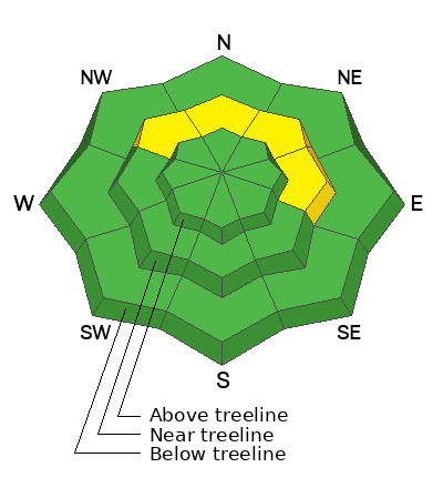
A MODERATE danger exists on near treeline slopes facing NW-N-NE-E. Human-triggered avalanches 1 to 2 feet deep are POSSIBLE failing on a persistent weak layer of faceted snow.
All other terrain has a low danger; watch for shallow wind drifts on isolated terrain features.
Above the treeline, you can increase your margin of safety by avoiding very steep, shallow, rocky areas and the most extreme terrain.
Low
Moderate
Considerable
High
Extreme
Learn how to read the forecast here
Special Announcements
Geyser Pass Road: Surface is mainly snowpacked and icy. AWD with good tires required.
Grooming Conditions: Gold Basin through Geyser Pass was groomed Saturday.
The beacon park is up and running. High pressure is a great time to work on your beacon skills.
Weather and Snow
6 A.M. Snow and Weather Data
24 Hour Snow: 0" 72 Hour Snow: 3" Season Total Snow: 63" Depth at Gold Basin: 30"
Winds on Pre-Laurel Peak: NNW 23-26 Temp: 2° F Percent of Normal (SWE): 81%
Weather
This morning, under clear skies, it is a very cold 2° F in Gold Basin. Ridgetop winds from the north-northwest have been blowing at light to moderate speeds overnight. Wind speeds will back off to 5 MPH and remain northwesterly. Daytime highs will reach 16° F and skies will be clear. Expect sunny conditions all week; temperatures will remain about ten degrees below normal. By Friday daytime highs will climb back up to the mid-20s F. Our next chance for snow is Saturday into Sunday, stay tuned for details.
General Conditions
Slopes above 10,000 feet have received three inches of low-density snow since Saturday. This small amount of new snow will slightly improve riding conditions. Above treeline, the new snow seems to have blown away, and you will find a variety of hard wind-scoured surfaces and sastrugi. These alpine zones have been heavily scoured and the chances of triggering an avalanche are unlikely. Elsewhere, the snow surface is very slow due to extremely cold temperatures. We attempted some low-angle meadow skipping yesterday (see our observation) and found the new snow skied way too slow. You might find some fun skiing in steeper, protected areas.
The chances of triggering an avalanche continue to decrease as we get further out from our last loading event. The most prominent avalanche problem is a layer of weak, faceted snow about a foot beneath the surface that was buried on 12/25. You may encounter a slab over this weak layer on slopes that face NW-N-E near treeline. Backcountry travelers should carefully evaluate the snowpack before committing to steep terrain.
Snowpack and Weather Data
Gold Basin SNOTEL site (10,000')
SNOTEL site near Geyser Pass Winter Trailhead (9600')
Wind Station on Pre-Laurel Peak (11,400')
NWS forecast for the La Sal Mountains.
Recent Avalanches
Ad
Avalanche Problem #1
Persistent Weak Layer
Type
Location
Likelihood
Size
Description
The primary avalanche concern is a weak layer of faceted snow from the December dry spell, buried on 12/25, about a foot below the surface on northwest, north, and east aspects. While this weak layer is widespread, the overlying slab required to create an avalanche is not. This problem is most pronounced near the treeline in areas where previous drifting has created an overlying slab. Slopes with a northerly component to their aspect are most suspect. Places like Exxon’s Folly (or anything resembling that) come to mind. Avalanches triggered 1–2 feet deep could potentially entrain enough snow to step down to basal facets near the ground. If you find a slab over this weak layer, dial back your slope angles to less than 30°.
Curious about low danger above treeline? Read the additional information below for more details.
Additional Information
Forecaster's Corner: We have dropped the danger above treeline from moderate to low. The current danger rose may appear strange or unconventional. Slopes in the alpine are heavily scoured on all aspects and the slabs and weak layers are not well connected across this terrain. Areas that are not heavily scoured have a deep snowpack and strong snow. The average height of snow in these areas is 4.5 to almost 6 feet deep. This is a much different snowpack compared to lower elevations. The chances of triggering an avalanche above treeline are low, but we continue to avoid steep, shallow, rocky areas to have the greatest margin of safety. Be sure to read my latest observation for more information.
Sign up for text alerts to get the most up to date information about changing conditions, road plowing, special avalanche announcements.
Follow us on Instagram @utavy_moab
General Announcements
This forecast is from the U.S.D.A. Forest Service, which is solely responsible for its content. This forecast describes general avalanche conditions and local variations always occur.