Forecast for the Moab Area Mountains

Eric Trenbeath
Issued by Eric Trenbeath on
Friday morning, January 22, 2021
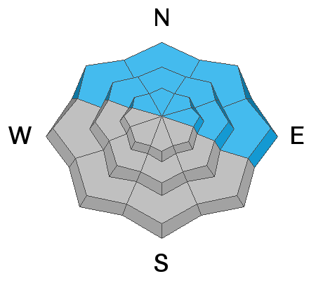
You can still trigger an avalanche on steep, northerly facing slopes that have enough snow to ski or ride. These areas are far and few between and the avalanche danger remains MODERATE. The current snowpack structure is very weak and the danger will quickly increase with any significant snow load. Look for rising danger over the next several days. Most south-facing slopes are bare and therefore have LOW to no avalanche danger.
Low
Moderate
Considerable
High
Extreme
Learn how to read the forecast here
Special Announcements
Do you have the essential avalanche rescue gear (transceiver, probe, and shovel) and do you know how to use them? Watch this video to see how the three pieces of equipment work together.
The Geyser Pass Road is plowed. The surface is snow packed on dirt.
The Lower Utah Nordic Alliance (LUNA) groomed all trails through Geyser Pass and Gold Basin on Tuesday.
Weather and Snow
Skies are cloudy, SW winds are light to moderate, and mountain temps are in the low to mid 20's. An eagerly anticipated storm system along the Pacific coast will move inland today and should start affecting our area by late this afternoon. I'm afraid this isn't going to be the big one but we'll take whatever we can get. We should see snow showers tonight that taper off by mid-morning tomorrow. 4"-8" are possible. A secondary low-pressure system will keep a chance for lingering showers into Sunday. By Monday night, the next cut-off low will move into the region bringing us our next shot for snow. Keep your fingers crossed for a continuation of the pattern!
Wind, temperature, humidity on Pre Laurel Peak (11,700')
Snotel site near Geyser Pass Trailhead (9600')
Storm totals at the Gold Basin study plot (10,000')
Snowpack Discussion
The meager snowpack has deteriorated into a pile of mostly weak, sugary, facets with a couple of buried crusts thrown in here and there and it won't take much of a load to create dangerous avalanche conditions. Snow cover ranges from about 12"-24" Winds have wreaked havoc on exposed terrain and most south-facing slopes are bare.
Ad
Avalanche Problem #1
Persistent Weak Layer
Type
Location
Likelihood
Size
Description
Anyone who has been following knows that our meager snowpack is rife with persistent weak layers of loose, sugary faceted snow with one or two crusts buried in there. It is still possible to trigger an avalanche on steep, north-facing slopes that have enough snow to ski or ride though these areas are far and few between. Looking to the future, any significant load of new snow will be too much for these weak layers to bear causing an immediate rise in avalanche danger. Unfortunately, this weak structure will probably remain with us for the rest of the season, and steep, north-facing terrain will most likely be off-limits until spring.
General Announcements
This forecast is from the U.S. Forest Service, which is solely responsible for its content. This forecast describes general avalanche conditions and local variations always occur.