UDOT PLANNED AVALANCHE CLOSURES!!

Forecast for the Moab Area Mountains

Dave Garcia
Issued by Dave Garcia on
Thursday morning, January 2, 2025
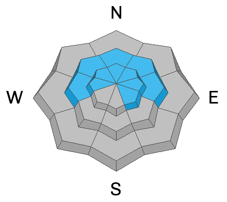
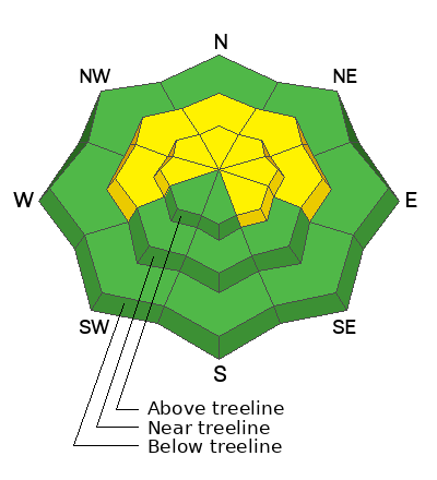
Heightened avalanche conditions exist on slopes that have a thick, cohesive slab overlying weak, faceted snow. The overall danger is MODERATE for avalanches failing on persistent weak layers. This problem is most pronounced above treeline on slopes that face W-N-E-SE, but slabs formed by previous blowing and drifting snow have penetrated some near treeline terrain on slopes that face W-N-E. Human-triggered avalanches remain POSSIBLE and you'll need to evaluate snow and terrain carefully to avoid today's avalanche problem.

It's still low tide out there and rocks, stumps, and logs are lurking just beneath the surface.
Low
Moderate
Considerable
High
Extreme
Learn how to read the forecast here
Special Announcements
Geyser Pass Road: Expect slick conditions on a hard, snowpacked and icy surface. AWD with good tires required.
Grooming Conditions: Gavin groomed up and over Geyser Pass on Monday. There is no classic track set, but according to one nordic enthusiast the corduroy is "as good as it gets for skating."
Now is a great time to dial in your safety gear including putting fresh new batteries in your beacons! Local shops across the state will be handing out free Batteries for Beacons now until February 1, 2025. All you need to do is fill out a quick survey and grab the AAA or AA batteries you need to keep your beacon fresh this season. Head into Moab Gear Trader to get yours!
Weather and Snow
6 A.M. Snow and Weather Data
24 Hour Snow: 0" 72 Hour Snow: 0" Season Total Snow: 52" Depth at Gold Basin: 27"
Winds on Pre-Laurel Peak: WNW 9-15 Temp: 29° F Percent of Normal (SWE): 109%
Weather
Today will be another beautiful day in the mountains. The temperature is 20 degrees warmer this morning than 24 hours ago. The mercury is currently sitting at 29 degrees and daytime highs will be in the low 30s. Winds will be light out of the West at 5-10 MPH. We can expect more of the same tomorrow, with highs creeping up to the mid 30s. On Saturday, a storm will bring snow to the Northern mountains and we will see mostly cloudy skies with light snow flurries.
General Conditions
Last week's storm dropped 7-10 inches of snow and really helped improve skiing and riding conditions. We have been finding great powder turns on sheltered slopes. Be sure and read Nate's observation from our field day on Wednesday and see the video below. Some exposed slopes were affected by the strong winds over the weekend and have variable turning conditions. Other open slopes were not affected and still offer great soft powder skiing. Solar aspects have very thin coverage, and many of these slopes are un-skiable.
A persistent weak layer problem exists on some slopes near treeline, and many slopes above treeline. As you travel through the backcountry today, look for thick, cohesive slabs of snow sitting above weak faceted snow that was previously the old snow surface. These slabs formed by blowing and drifting snow exist on some near treeline terrain, but are not widespread. Slopes near treeline should be evaluated individually before committing to anything steeper than 30 degrees. You are most likely to encounter avalanche problems above treeline where slab formation is more widespread, especially on slopes with a Northerly component to their aspect.
Snowpack and Weather Data
Gold Basin SNOTEL site (10,000')
SNOTEL site near Geyser Pass Winter Trailhead (9600')
Wind Station on Pre-Laurel Peak (11,400')
NWS forecast for the La Sal Mountains.
Recent Avalanches
See the avalanche database here.
There was a fatal avalanche accident in Porter Fork of the Wasatch Range that occurred on Saturday. Weak sugary faceted snow from earlier in the season was what made the avalanche release. Details here.
There was a second fatal avalanche accident in Silver Fork of the Wasatch Range on Tuesday. Old buried faceted snow was the weak layer in this avalanche also. Details here.
Ad
Avalanche Problem #1
Persistent Weak Layer
Type
Location
Likelihood
Size
Description
Weak and faceted snow is widespread on the shady side of the compass. Slopes below treeline lack a cohesive slab. As you gain elevation, you may encounter thicker slabs near treeline and above. Slab formation is most pronounced above treeline, and this is where you are most likely to find avalanche problems. There are two main weak layers of concern: facets at the base of the snowpack, and very weak snow found just below the new and drifted snow. I am most concerned about the weak layer in the upper pack. Recently formed slabs are more likely to overload this layer, and avalanches will fail here first. Any triggered slide has the potential to entrain enough snow to step down to the basal facets, causing deep and dangerous avalanches. If you are skiing slopes steeper than 30 degrees, you'll need to carefully evaluate the snow for signs of a slab over a weak layer.
Additional Information
Sign up for text alerts to get the most up to date information about changing conditions, road plowing, special avalanche announcements.
Follow us on Instagram @utavy_moab
General Announcements
This forecast is from the U.S.D.A. Forest Service, which is solely responsible for its content. This forecast describes general avalanche conditions and local variations always occur.