Join us at our 2nd Annual Blizzard Ball

Forecast for the Moab Area Mountains

Eric Trenbeath
Issued by Eric Trenbeath on
Friday morning, January 3, 2025
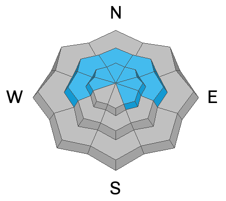
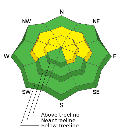
The avalanche danger is MODERATE on steep slopes near treeline and above that face W-N-E-SE. The most dangerous slopes face N-E but human triggered avalanches are possible on any slope where dense, cohesive slabs exist over top of weak, faceted snow. Careful slope evaluation is necessary before venturing into terrain steeper than 30 degrees.

It's still low tide out there and rocks, stumps, and logs are lurking just beneath the surface.
Low
Moderate
Considerable
High
Extreme
Learn how to read the forecast here
Special Announcements
Geyser Pass Road: Expect slick conditions on a hard, snowpacked and icy surface. AWD with good tires required.
Grooming Conditions: LUNA will be up today to groom.
Now is a great time to dial in your safety gear including putting fresh new batteries in your beacons! Local shops across the state will be handing out free Batteries for Beacons now until February 1, 2025. All you need to do is fill out a quick survey and grab the AAA or AA batteries you need to keep your beacon fresh this season. Head into Moab Gear Trader to get yours!
Weather and Snow
6 A.M. Snow and Weather Data
24 Hour Snow: 0" 72 Hour Snow: 0" Season Total Snow: 52" Depth at Gold Basin: 27"
Winds on Pre-Laurel Peak: SW 20-25 G 33 Temp: 34° F Percent of Normal (SWE): 109%
Weather
SW winds have been on the increase since around midnight and are currently blowing in the 20-25 mph range along ridge tops. Today will be warm and slightly breezy under mostly sunny skies. We'll see mostly cloudy skies tonight ahead of yet another storm system tracking through to the north. Saturday will be mostly cloudy and breezy with a chance for snow. Sunday looks to be mostly sunny.
General Conditions
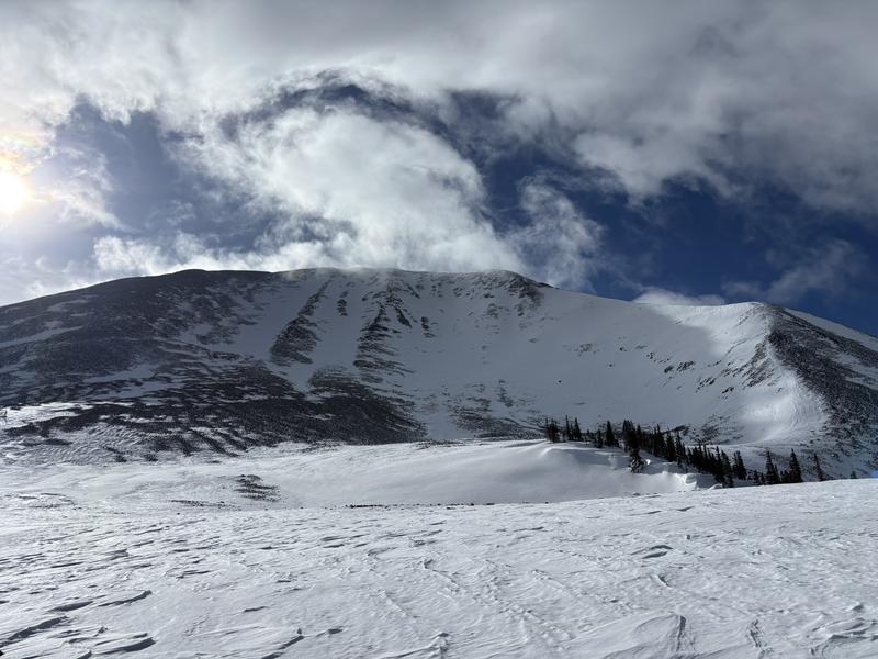
It's been about a week since the last storm but folks are still finding soft snow and good good turning conditions in sheltered areas. Ryan Huels was out yesterday tramping around the base of Mount Mellenthin's north side. He reported finding soft snow in the trees while slopes in the alpine were either stripped of snow or hard. That said, other folks are finding areas above treeline where soft snow remains. It's hit and miss up there and your best, as well as safest bet is on sheltered northerly facing terrain below treeline. Solar aspects have very thin coverage, and many of these slopes are un-skiable.
The notoriously wind blasted north face of Mount Mellenthin near Geyser Pass. Drop below treeline for soft snow conditions. Ryan Huels photo.
For proof that good turns can be found, check out the video below of Dave Garcia and pro observer Nate Ament getting the goods.
Snowpack and Weather Data
Gold Basin SNOTEL site (10,000')
SNOTEL site near Geyser Pass Winter Trailhead (9600')
Wind Station on Pre-Laurel Peak (11,400')
NWS forecast for the La Sal Mountains.
Recent Avalanches
See the avalanche database here.
There was a fatal avalanche accident in Porter Fork of the Wasatch Range that occurred on Saturday. Weak sugary faceted snow from earlier in the season was what made the avalanche release. Details here.
There was a second fatal avalanche accident in Silver Fork of the Wasatch Range on Tuesday. Old buried faceted snow was the weak layer in this avalanche also. Details here.
Ad
Avalanche Problem #1
Persistent Weak Layer
Type
Location
Likelihood
Size
Description
Weak and faceted snow is widespread on the shady side of the compass. Slopes below treeline lack a cohesive slab. As you gain elevation, you may encounter thicker slabs near treeline and above. Slab formation is most pronounced above treeline, and this is where you are most likely to find avalanche problems. There are two main weak layers of concern: facets at the base of the snowpack, and very weak snow found just below the new and drifted snow. We are most concerned about the weak layer in the upper pack. Recently formed slabs are more likely to overload this layer, and avalanches will fail here first. Any triggered slide has the potential to entrain enough snow to step down to the basal facets, causing deep and dangerous avalanches. If you are skiing slopes steeper than 30 degrees, you'll need to carefully evaluate the snow for signs of a slab over a weak layer.
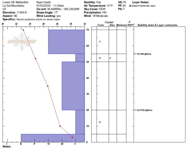
This snowpit from Ryan Huels perfectly illustrates the snow structure we are most concerned with. Note the obvious dense slab on top over weak faceted snow. The diagram also illustrates the weak faceted layer at the base of the snowpack.
Additional Information
Sign up for text alerts to get the most up to date information about changing conditions, road plowing, special avalanche announcements.
Follow us on Instagram @utavy_moab
General Announcements
This forecast is from the U.S.D.A. Forest Service, which is solely responsible for its content. This forecast describes general avalanche conditions and local variations always occur.