Forecast for the Moab Area Mountains

Eric Trenbeath
Issued by Eric Trenbeath for
Sunday, January 13, 2019
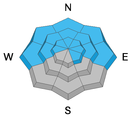
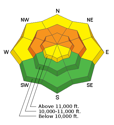
The avalanche danger remains CONSIDERABLE, and human triggered avalanches failing 2'-3' deep on a layer of weak, sugary, faceted snow are likely on steep slopes facing W-N-E. We are trending downward on the danger scale, but this is the period when most avalanche accidents happen. Continue to avoid steep, avalanche prone slopes, especially if they appear to be wind drifted, and be alert to signs of instability such as cracking or collapsing in the snowpack. Stick to low angle, wind sheltered terrain.
Low
Moderate
Considerable
High
Extreme
Learn how to read the forecast here
Special Announcements
We will be offering a Backcountry 101 avalanche course on Feb 8, 9. It's a great way to up your avalanche knowledge with both classroom, and hands on field instruction. Click here for more details and to register.
We've installed an avalanche beacon tester and a beacon training park at the Geyser Pass Trailhead! Be sure you are beeping and practice your rescue skills!
Thanks to UAC volunteer Ed Grote, ex La Sal forecaster Max Forgensi, and LUNA volunteer Matt Hebberd for helping out with this. You guys rock!
The new UAC IOS mobile app is now available on the app store. Check out the new "My Weather" feature.
Check out the new free online avalanche course series developed by the Utah Avalanche Center. This is a great way to refresh your skills or prepare you for a Backcountry 101 or Level 1 class.
Weather and Snow
Skies are mostly clear, ESE winds are light, and mountain temps are in the single digits. A light dusting of snow fell in the mountains yesterday. We should see some clouds developing with a chance for isolated snow showers in the mountains today. Light ESE winds will shift to the SW by this afternoon. High temps will be in the low 20's. On the horizon, a decent looking storm system should begin to affect our area on Wed.
I don't have any recent reports from the backcountry. On Thursday however, I was still observing pretty wide spread collapsing of the snowpack, a sure sign of instability. Time heals, and I'm sure things are starting to quiet down a bit, but for me, the current snowpack structure continues to warrant serious caution. I plan to get out today and travel fairly far and wide to get a good grasp on things. Snow conditions are soft in sheltered areas but a bit tricky due to their inverted nature. Wind and sun over the past several days have taken a toll on the snow surface in exposed areas. The last storm has greatly improved coverage, as well as our overall water content. Base depth in Gold Basin is 38".
New snow totals in Gold Basin (10,000')
Snow totals at the Geyser Pass Trailhead (9600')
Wind, temperature, and humidity on Pre Laurel Peak (11,700')
National Weather Service point forecast.
Recent Avalanches
No avalanche activity had been reported since Tuesday.
Ad
Avalanche Problem #1
Persistent Weak Layer
Type
Location
Likelihood
Size
Description
Time heals and things are quieting down a bit, but Sunday's storm snow blew and drifted, and dangerously overloaded a weak snowpack. Human triggered avalanches stepping down into buried persistent weak layers of loose, sugary, faceted snow continue to be likely, primarily on slopes facing the north half of the compass, but W and SE facing slopes are not immune. The video below illustrates how a persistent weak layer on a NE aspect reacted to the new snow load. Though this video is now several days old, I've continued to observe similar results in other locations.
Avalanche Problem #2
Wind Drifted Snow
Type
Location
Likelihood
Size
Description
Winds have blown and drifted snow throughout the week, and areas of unstable snow have formed in many locations. Above treeline you may find drifts on all aspects on the lee sides of ridge crests and terrain features. Below treeline, most of the drifting will be on slopes with a northerly aspect. Avoid any stope slope that you suspect may be wind loaded - look for telltale signs such as a smooth rounded appearance, or cracking in the snow surface.
General Announcements
Your information can save lives. If you see anything we should know about, please help us out by submitting snow and avalanche observations HERE. You can also call me at 801-647-8896, or send me an email: [email protected].
Support the UAC through your daily shopping. When you shop at Smith's, or online at REI, Backcountry.com, Patagonia, NRS, Amazon, eBay by clicking on these links, they donate a portion of your purchase to the UAC. If you sell on eBay, you can have your See our Affiliate Page for more details on how you can support the UAC when you shop
This advisory is from the U.S.D.A. Forest Service, which is solely responsible for its content. This advisory describes general avalanche conditions and local variations always occur.