Forecast for the Moab Area Mountains

Eric Trenbeath
Issued by Eric Trenbeath for
Thursday, January 11, 2024
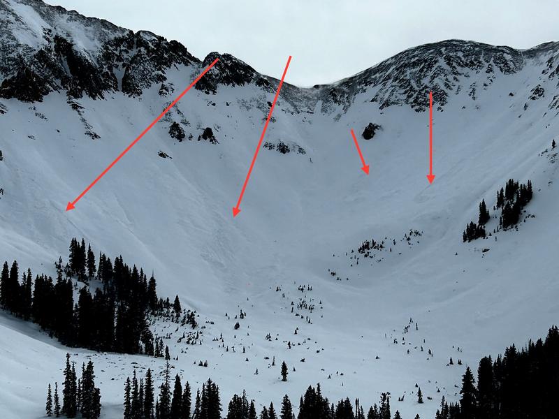
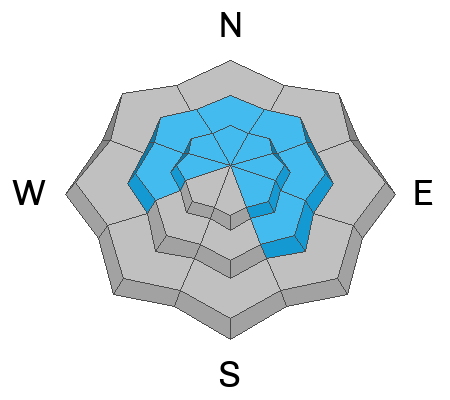
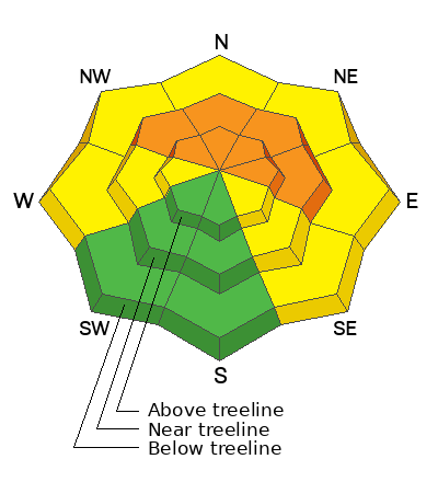
A CONSIDERABLE avalanche danger exists on steep, wind drifted slopes near treeline and above that face NW-N-E. Human-triggered avalanches are LIKELY in these areas. Triggered wind slabs in these areas have the potential to step down into weaker, faceted snow underneath causing a deeper, and more dangerous avalanche.
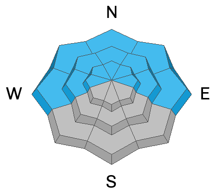
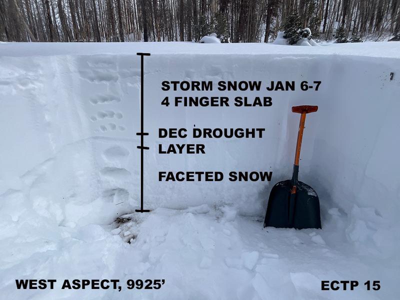
A MODERATE danger exists on W and SE aspects where you can detect recent deposits of wind drifted snow. West facing slopes also harbor weak, faceted snow underneath, and deeper, more dangerous avalanches are possible in these areas.
Most south facing terrain has LOW danger due to the effects of wind scouring and low snow conditions. Small avalanches on isolated terrain features remain possible.
Low
Moderate
Considerable
High
Extreme
Learn how to read the forecast here
Special Announcements
With the arrival of new snow, sign up for our Backcountry 101 course Jan 19, 20!
Sign up for forecast region-specific text message alerts. You will receive messages about changing avalanche conditions, watches, and warnings.
Follow us on Instagram @utavy_moab
Road Conditions: The Geyser Pass Road was plowed on Monday. It remains snow packed and 4x4 or AWD is recommended.
Grooming: Expect fresh snow on the trails today.
Weather and Snow
6:00 a.m. Snow and Weather Data
24 Hour Snow 5" 72 Hour Snow 5" Season Total Snow 69" Base Depth at Gold Basin 37"
Winds on Pre-Laurel Peak: WNW 10-15 Temp 12˚ F

Weather
A mid level low pressure system moving through the area has brought a few inches of fresh snow to the mountains this morning. Overnight winds from the southwest averaged 25 mph with gusts to 40 for a 12 hour period. They backed off and began their shift to west and then northwest around 3:00 a.m. Snow showers may linger this morning but I think it's about over. It's going to be cold up there today with patchy blowing snow, blustery northwest winds and high temps of around 10-15F. We should see some partial clearing. An active weather pattern continues through the weekend, but most of the action will be up north where apocalyptic snow totals are being forecasted for the Central Wasatch.
General Conditions
The new snow will provide a bit of a refresh which is much needed. In my travels yesterday I found conditions to be a bit surly. Winds have been the most influential weather factor since last weekend's storm event, and much of the landscape has been stripped, scoured, or crusted with alternating areas of deposition where hard wind slabs have formed. Last week's snow totals of around 2' have settled out significantly and we are developing a slab over top of the weak underlying snowpack. This does not bode well for the future. Outward signs of instability such as cracking and whumphing are not yet presenting themselves, but just by jabbing your pole through to the ground, or trenching in with your sled track, you can feel how weak it is under there. The bottom line is that we are going to need to tread lightly over these buried persistent weak layers for awhile, and that means generally avoiding steep, northerly facing terrain.
Keep those observations coming in! For a list of recent observations go here.
Settlement cones around the base of trees and these young aspen shoots indicate how much the low density snow from last weekend has settled and consolidated.
Snowpack and Weather Data
Gold Basin Storm Stake (10,000')
Gold Basin SNOTEL site (10,000')
SNOTEL site near Geyser Pass Winter Trailhead (9600')
Wind Station on Pre-Laurel Peak (11,400')
NWS forecast for the La Sal Mountains.
Recent Avalanches
Numerous small D1 avalanches occurred on a wide variety of aspects during the height of the storm on Sunday, or possibly just after during Monday's wind event. Most of these avalanches involved soft slabs of wind-drifted snow failing on top of the weak December drought layer.
Several avalanches occurred in Talking Mountain Cirque. The slide in the center left is one of the few D2 avalanches observed.
Ad
Avalanche Problem #1
Wind Drifted Snow
Type
Location
Likelihood
Size
Description
Winds continue to hammer, blowing and drifitng snow on to leeward facing slopes. Last night's few inches of fresh snow will be blown into shallow but sensitive, soft slabs on steep, northerly apects, in some cases covering up older hard slabs that formed earlier in the week. On northerly aspects, slabs exist over top of weak, sugary, faceted snow. Deeper, and more dangerous human triggered avalanches are likely in these areas.
Isolated slabs of wind drifted snow may also be found on other aspects. Look for them on the leeward sides of ridge crests and terrain features such as gully walls and subridges. They are often recognizable by their smooth, rounded appearance, and cracking is a sign of instability. Old hard slabs will support your weight initially and they may sound hollow underneath. Hard slabs may lure you further down slope before breaking well above you. Avoid steep, wind drifted slopes.
Blowing and drifting snow on Tuesday.
Avalanche Problem #2
Persistent Weak Layer
Type
Location
Likelihood
Size
Description
The snow pack overall is weak, but the December drought layer (buried roughly 15 inches deep) is the primary layer of concern. A slab now exists on top of this weak layer. Near treeline and below, the storm snow has settled into a thick, cohesive layer. Near treeline and above, elevated winds have stiffened the snow and produced slabs of wind drited snow overtop of this weak layer. Outward signs of instability such as cracking and whumphing are not yet presenting themselves, but just by jabbing your pole through to the ground you can feel the poor structure. Below, see a snowpit and extended column test results from a west aspect near 10,000'. This weak layer is present at all elevations on slopes facing W-N-E.
Additional Information
To fulfill our mission, the UAC relies on our amazing backcountry community. Your support helps pay for the daily avalanche forecast, free awareness presentations across the state, and new tools like the new Avalanche and Observation Explorer. As we welcome the new year, please consider donating to the UAC.
General Announcements
This forecast is from the U.S.D.A. Forest Service, which is solely responsible for its content. This forecast describes general avalanche conditions and local variations always occur.