Forecast for the Moab Area Mountains

Dave Garcia
Issued by Dave Garcia for
Wednesday, January 10, 2024
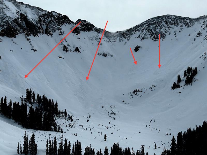
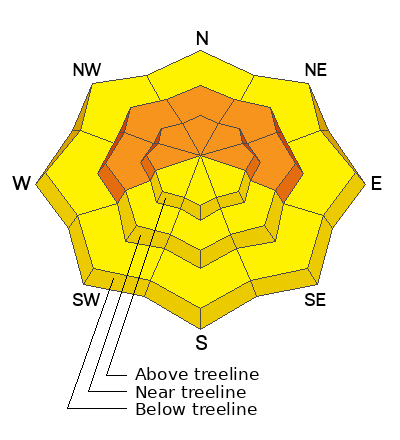
CONSIDERABLE avalanche danger exists near treeline and above on slopes that face W-N-E. Human-triggered avalanches are LIKELY. The danger is most pronounced on slopes that have been recently loaded by the wind, where you will find both soft and hard slabs of wind-drifted snow.
Out of the wind zone, you will find a MODERATE danger where soft snow has settled into a cohesive slab. While these avalanches will be smaller and pockety in nature, they could still take you for a rough ride, or bury you in a terrain trap.
Low
Moderate
Considerable
High
Extreme
Learn how to read the forecast here
Special Announcements
With the arrival of new snow, sign up for our Backcountry 101 course Jan 19, 20!
Sign up for forecast region-specific text message alerts. You will receive messages about changing avalanche conditions, watches, and warnings.
Follow us on Instagram @utavy_moab
Road Conditions: The Geyser Pass Road was plowed on Monday. It remains snow covered and 4x4 or AWD is recommended.
Grooming: Gavin groomed out to Geyser Pass and the Gold Basin trail and Matt set classic track into Gold Basin.
Weather and Snow
6:00 a.m. Snow and Weather Data
24 Hour Snow 0" 72 Hour Snow 14" Season Total Snow 64" Base Depth at Gold Basin 34"
Winds on Pre-Laurel Peak: WNW 16 G 19 Temp 12˚ F

Weather
The next in a series of storms will impact the area today through Thursday with the Northern mountains favored for significant accumulations. There are lots of dynamics with this system, but it is moisture starved and won't be a big producer for the La Sals. Today will be partly sunny with highs in the low teens. Westerly winds will blow 20-30 mph. Light snow showers will arrive late in the day. Overnight lows will crash to 0 degrees and Westerly winds will gust up to 45 mph. We should stack up a few inches of snow overnight. Snow, cold, and wind are expected to dominate conditions for the latter part of the week, this weekend, and early next week, but so far snow totals are not impressive.
General Conditions
The snow quality has really diminished since Sunday when we were enjoying in your face ultra-fluff. Strong winds have scoured many slopes, leaving a mix of salt and pepper alternating with soft slabs in subtle terrain features, and big hard slabs of wind-drifted snow in gullies and starting zones. In alpine terrain, these slabs of wind-drifted snow are widespread and are sitting on top of a fragile house of cards. In sheltered areas out of the wind zone the snow has settled quite a bit. Near tree line and below the snow has become thick and heavy. The surface snow has really slabbed up in the last few days and is sitting on top of weak faceted snow from the December drought.
Maggie Nielson and Jason Ramsdell were out and about yesterday and sent in this observation.
Nate Ament and I stomped around the high ridgelines up to Pre-Laurel peak and here's what we found.
Snowpack and Weather Data
Gold Basin Storm Stake (10,000')
Gold Basin SNOTEL site (10,000')
SNOTEL site near Geyser Pass Winter Trailhead (9600')
Wind Station on Pre-Laurel Peak (11,400')
NWS forecast for the La Sal Mountains.
Recent Avalanches
We got eyes on numerous small D1 avalanches that occurred on a wide variety of aspects during the height of the storm on Sunday, or possibly just after during Monday's wind event. Most of these avalanches involved soft slabs of wind-drifted snow failing on top of the weak December drought layer.
We observed several avalanches in Talking Mountain Cirque, and quite a bit of debris. The slide in the center left is one of the few D2 avalanches observed.
Ad
Avalanche Problem #1
Wind Drifted Snow
Type
Location
Likelihood
Size
Description
Westerly winds overnight remained elevated and will continue to blow and drift snow today creating fresh soft slabs in starting zones. While many slopes in the alpine have been scoured, slabs of wind-drifted snow are widespread, particularly near treeline and they are resting on top of a weak and faceted snowpack. Many of these slopes hang in the balance, just waiting for the weight of a skier or rider to trigger an avalanche.
In our travels yesterday we encountered sensitive soft slabs and more stubborn hard slabs on all aspects. These slabs were cracking and collapsing beneath of our skis. If you feel this, you have found a wind-slab. Backcountry travelers need to avoid fat, rounded pillows of snow. Hard slabs will sound hollow like a drum. The tricky thing about hard slabs is that they allow you to get further out on to them and then break well above you.
Blowing and drifting snow on Tuesday.
Avalanche Problem #2
Persistent Weak Layer
Type
Location
Likelihood
Size
Description
The snow pack overall is weak, but the December drought layer (buried roughly 15 inches deep) is the primary layer of concern today. A slab now exists on top of this weak layer. Near treeline and below, the storm snow has settled into a thick, cohesive layer. Near treeline and above, elevated winds have stiffened the snow and produced slabs over the weak layer. Both of these scenarios mean we have strong snow over weak snow, the perfect recipe for slab avalanches. Recent avalanche activity illustrates the sensitivity of the December drought layer and this has me keeping my terrain choices conservative for the time being.
Additional Information
To fulfill our mission, the UAC relies on our amazing backcountry community. Your support helps pay for the daily avalanche forecast, free awareness presentations across the state, and new tools like the new Avalanche and Observation Explorer. As we welcome the new year, please consider donating to the UAC.
General Announcements
This forecast is from the U.S.D.A. Forest Service, which is solely responsible for its content. This forecast describes general avalanche conditions and local variations always occur.