Forecast for the Moab Area Mountains

Dave Garcia
Issued by Dave Garcia for
Tuesday, January 9, 2024
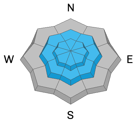
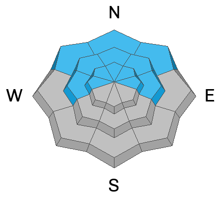
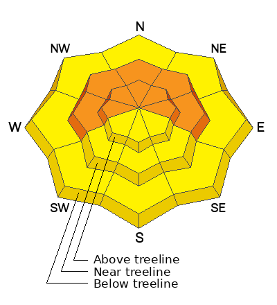
There is a CONSIDERABLE avalanche danger near treeline and above on slopes that face W-N-E. These slopes harbor buried persistent weak layers and recent blowing and drifting snow has pushed these layers to their tipping point. Human-triggered avalanches 2 feet deep or more are LIKELY. On the south side of the compass, we lose the facets and find a MODERATE danger, where Human-triggered avalanches in fresh slabs of wind-drifted snow are POSSIBLE.
Low
Moderate
Considerable
High
Extreme
Learn how to read the forecast here
Special Announcements
With the arrival of new snow, sign up for our Backcountry 101 course Jan 19, 20!
Sign up for forecast region-specific text message alerts. You will receive messages about changing avalanche conditions, watches, and warnings.
Follow us on Instagram @utavy_moab
Road Conditions: The Geyser Pass Road was plowed on Monday. It remains snow covered and 4x4 or AWD is recommended.
Grooming: Gavin groomed out to Geyser Pass and the Gold Basin trail.
Weather and Snow
6:00 a.m. Snow and Weather Data
24 Hour Snow 0" 72 Hour Snow 14" Season Total Snow 64" Base Depth at Gold Basin 37"
Winds on Pre-Laurel Peak: N 15 G 20 Temp 2˚ F

Weather
Temperatures remain cold in the wake of Sunday's storm. It is currently 2 degrees in Gold Basin and we can expect high temperatures to reach the mid-teens. The day will start off with clear skies and a bit of sunshine, cloud cover will slowly build as the day progresses. The wind will shift to the West and back off slightly, blowing 15-20 mph. A series of storms will bring good amounts of snow to Northern Utah this week. The weather remains unsettled here in the La Sals, with below normal temperatures, wind, and a chance for some light accumulations mid-week. The weekend brings another chance for light snow, but so far totals look unimpressive.
General Conditions
With three feet of settled snow in Gold Basin, it is finally game on for skiing and riding. Below tree line, conditions remain excellent. You can still find light fluffy in your face powder out of the wind zone. Gain some elevation, and things will start to change. Moderate to strong winds have been blowing from the North for the past 36 hours. These winds will have no trouble picking up the ultra-light fluff from Sunday's storm and depositing fresh slabs on all aspects. These slabs will be quite sensitive in their own right. Things get a little more complicated on slopes that face W-N-E that harbor a very weak snowpack. On these slopes stiff, cohesive slabs are resting on top of the very weak and sensitive December drought layer. It's game on for skiing, but it's also game on for avalanches, especially near tree line and above.
Snowpack and Weather Data
Gold Basin Storm Stake (10,000')
Gold Basin SNOTEL site (10,000')
SNOTEL site near Geyser Pass Winter Trailhead (9600')
Wind Station on Pre-Laurel Peak (11,400')
NWS forecast for the La Sal Mountains.
Recent Avalanches
No recent avalanches have been reported, but that doesn't mean they haven't happened. Visibility was extremely limited during the storm on Sunday, and yesterday the road was closed for plowing, so very few people were out and about. I'm heading up today to get eyes on things.
Ad
Avalanche Problem #1
Wind Drifted Snow
Type
Location
Likelihood
Size
Description
Moderate to strong winds from the North have been blowing for the past 36 hours. Winds shift to the West today and will continue to drift snow. With plenty of low-density snow available for transport backcountry riders will encounter soft slabs of wind-drifted snow on all aspects near treeline and above. Some of these drifts will be deeper than 2 feet. These slabs will be sensitive and easily triggered by our additional weight. Fresh slabs will be most pronounced on leeward slopes, but sustained high winds (especially when they blow from the North) can load any aspect.
On slopes that face W-N-E, any triggered wind slab has the potential to step down to faceted weak layers causing a deeper and more dangerous avalanche.
Avoid any steep slopes that appear, round, fat, and pillowy.
Avalanche Problem #2
Persistent Weak Layer
Type
Location
Likelihood
Size
Description
The snow pack overall is weak, but the December drought layer (buried roughly 20 inches deep) is the primary layer of concern today. Stability tests show this layer is very weak and sensitive. So far, the new snow has not been enough to produce slab avalanches, because it is low-density and fell without much wind. Things have changed, as recent winds have stiffened the snow and produced slabs over the weak layer, creating dangerous conditions. You will find these conditions in the wind zone near treeline and above today. Additionally, signs of settlement could also indicate a slab has formed in the new snow, and this can occur at any elevation or aspect. Shooting cracks or audible collapses are good signs that a slab has formed. If you do not have the experience to identify (and avoid) a slab over a weak layer, keep it simple and stick to slopes less steep than 30 degrees.
Additional Information
To fulfill our mission, the UAC relies on our amazing backcountry community. Your support helps pay for the daily avalanche forecast, free awareness presentations across the state, and new tools like the new Avalanche and Observation Explorer. As we welcome the new year, please consider donating to the UAC.
General Announcements
This forecast is from the U.S.D.A. Forest Service, which is solely responsible for its content. This forecast describes general avalanche conditions and local variations always occur.