Forecast for the Moab Area Mountains

Dave Garcia
Issued by Dave Garcia on
Thursday morning, January 1, 2026
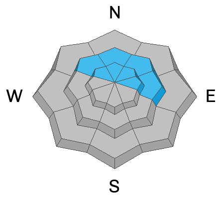
Recent and wind drifted snow have increased the avalanche danger to MODERATE on steep slopes near and above tree line facing NW-N-NE-E. The problem is two fold, and human triggered avalanches involving both the new snow, as well as avalanches stepping down into buried persistent weak layers are possible. Steep, wind drifted slopes are the most dangerous, and slopes with more than about 8 inches of new snow areas should be avoided. I'm less certain about the possibility for deeper avalanches, but with over an inch of new water weight, I'm stepping back.
Conditions remain very thin, and hazards such as rocks and logs have just been thinly covered.
Low
Moderate
Considerable
High
Extreme
Learn how to read the forecast here
Special Announcements

Geyser Pass Road Conditions: The road is mostly dry dirt with a few sections of packed snow and ice up high. All wheel drive and good tires are recommended.

Grooming: Trails haven't been groomed for over a week. We're experiencing some mechanical difficulties with the equipment.

Friday, January 30 - Saturday, January 31 - Moab Backcountry 101 Class - Our annual local backcountry avalanche class. Click here for information and registration. Moab and Monticello locals can use the discount code MOAB-LOCAL for a 10% discount.

Weather and Snow

24 Hour Snow: 0" 72 Hour Snow: 0" Season Total Snow: 22" Depth at Gold Basin: 12"

Winds on Pre-Laurel Peak: S 18 G30 Temp: 34° F

Weather

Under cloudy skies, it is 34°F in Gold Basin this morning. Winds are moderate, blowing out of the southwest. Temperatures at 10,000 feet will drop to the upper 20s°F, and winds will remain moderate out of the SW with strong gusts in the 30 MPH range. Snowfall is expected to begin early this morning. The heaviest precipitation rates will occur overnight and into early Friday morning. I am still optimistic for 3 to 6 inches of total snow. A ridge of high pressure builds on Saturday with sunny skies and warm temperatures. This ridge is short-lived as some anomalous moisture moves in on Sunday with passing high clouds and a low chance of light snow showers. We're watching a low-pressure system off the Pacific Northwest, which will bring our next chance for snow on Monday.

General Conditions

I toured up to Gold Basin on Tuesday and found dust on crust conditions. There was almost 1 inch of recent snow capping the melt-freeze crust from Christmas Day. Sadly, this is the best skiing I have had in a while. The melt-freeze crust and rain crust below it allowed for easy travel both uphill and down. The mountains should get a decent refresh today. There may be a few inches of new snow on the ground by this afternoon and even more tomorrow morning. Keep in mind that many south-facing slopes are bare and unskiable. Polar aspects still hold 12 to 24 inches of snow.

The danger rose has been full green since December 10th, with no avalanche problems listed. This afternoon, we will develop our first avalanche problem in quite some time in the form of wind-drifted snow. Expect slabs of wind-drifted snow to form on leeward slopes above treeline. Like all storms this season, this one is difficult to forecast, and I am a little unsure of the timing. One thing that's for sure is that new snow and wind create wind slabs. Pay attention to changing conditions, and it will be easy to avoid any avalanche problems today.

Check out Eric's video from his fieldwork on Monday.

Snowpack and Weather Data

Gold Basin SNOTEL site (10,000')
SNOTEL site near Geyser Pass Winter Trailhead (9600')
Wind Station on Pre-Laurel Peak (11,400')
NWS forecast for the La Sal Mountains.
Recent Avalanches
No recent activity has been observed. Click here for the complete avalanche database.
Avalanche Problem #1
New Snow
Type
Location
Likelihood
Size
Description

Avalanches involving new and wind drifted snow are possible today with an underlying slick snow surface, especially on those slopes that have seen preferential deposition from the wind. Avoid steep slopes today that have more than about 8 inches of accumulated new snow. Wind drifted areas often have a smooth, rounded appearance and cracking is a sign of instability.

Avalanche Problem #2
Persistent Weak Layer
Type
Location
Likelihood
Size
Description
I'm less certain about the propensity for avalanches to step down into buried persistent weak layers, but this type of avalanche would be much more dangerous failing 2-3 feet deep. The Christmas rain crust is capping a snowpack that consists almost entirely of loose, sugary faceted snow. We've received a significant load of water and this is the first real test. I'm not sure if it's enough to fail below the crust yet, but if it did, it would be dangerous. So for now, I'm going to avoid steep slopes on the north side of the compass. For more on that, see the video below.
Additional Information
General Announcements
This forecast is from the U.S.D.A. Forest Service, which is solely responsible for its content. This forecast describes general avalanche conditions and local variations always occur.