Forecast for the Logan Area Mountains

Toby Weed
Issued by Toby Weed for
Sunday, April 23, 2023
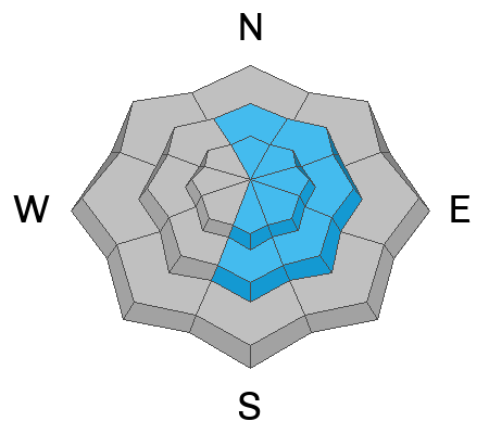
Heightened conditions are found in drifted mid and upper-elevation terrain, the danger is MODERATE, and people could trigger shallow wind slab avalanches on slopes steeper than 30°. Intense sun and warming temperatures will elevate the danger of wet loose avalanches in sunny terrain. Much less snow accumulated at lower elevations, overnight temperatures dropped well below freezing, and the danger is LOW.

Evaluate snow and terrain carefully.
Low
Moderate
Considerable
High
Extreme
Learn how to read the forecast here
Special Announcements
The UAC is sad to report that a resident was killed by a roof avalanche on Monday, April 17th, in the Town of Brighton. A report is available HERE.
Weather and Snow
This is our last daily forecast for the season, but that doesn’t mean there will be no more avalanches in the backcountry. We are amazed by how deep the snowpack is and the incredible coverage.

The 8400’ Tony Grove Snotel reports 11 inches of heavy new snow from Friday’s storm. It’s 21° F with 130” of total snow. It’s 15° F and winds are blowing 7 mph from the northwest at the 9700' CSI Logan Peak weather station.

Here is the NWS point forecast (36 hrs) for upper elevations in the central Bear River Range:
Today: Partly sunny, with a high near 40. Southeast wind around 7 mph becoming west southwest in the afternoon.
Tonight: A 40 percent chance of snow showers after midnight. Mostly cloudy, with a low around 27. South wind 6 to 8 mph. New snow accumulation of less than a half inch possible.
Monday: Snow showers before noon, then rain showers. Some thunder is also possible. High near 42. West southwest wind 8 to 14 mph. Chance of precipitation is 100%. New snow accumulation of less than a half inch possible.

Unsettled weather will continue into the week, with gradually rising temperatures and sunny conditions expected Wednesday and Thursday.
Recent Avalanches
  • At least a couple snowmobiler triggered wind slab avalanches occurred yesterday in drifted upper-elevation terrain.
    *Christmas Tree Bowl, remote from 60', 1'x 300', running ~600vrt', ESE @ 9600' (perhaps on sun-crust/facets). REPORT
    *East Miller Bowl (chute), 18"x 45', ~400vrt', NNE @ 8800'. REPORT
  • An observer reports intentionally triggering a shallow avalanche of wind-drifted storm snow on Friday near Steam Mill Peak on a drifted northeast-facing slope at 9100'. The report is HERE
  • For a list of recent avalanches in the Logan Zone go HERE.
  • Find a list of all recent observations & avalanches from across Utah go HERE.
Ad
Avalanche Problem #1
Wind Drifted Snow
Type
Location
Likelihood
Size
Description

  • In windy terrain people could trigger fresh slabs of wind-drifted snow a foot or two thick. These could produce avalanches wider than expected that might run pretty fast and far on smooth slick slopes and well-greased avalanche paths.
  • Isolated natural avalanches are possible this morning. The influence of rapid solar heating could cause fresh wind slabs to become more cohesive and unstable, perhaps easily sliding off a solid underlying crust.
  • Shallow soft slab or loose wet avalanches are possible on steep slopes with sufficient recent accumulations. Small avalanches might knock you off your feet and send you for a slide on slick and hard underlying snow. If you venture into steep terrain be aware of trees, cliffs, or other potential terrain traps you could be swept into.
Avalanche Problem #2
Wet Snow
Type
Location
Likelihood
Size
Description
The powerful April sun will quickly moisten the fresh snow and wet loose avalanches entraining big piles of heavy snow are possible. Be especially cautious in steep terrain with or trees, benches, or other terrain traps below. Avoid being beneath other riders or parties.
Additional Information
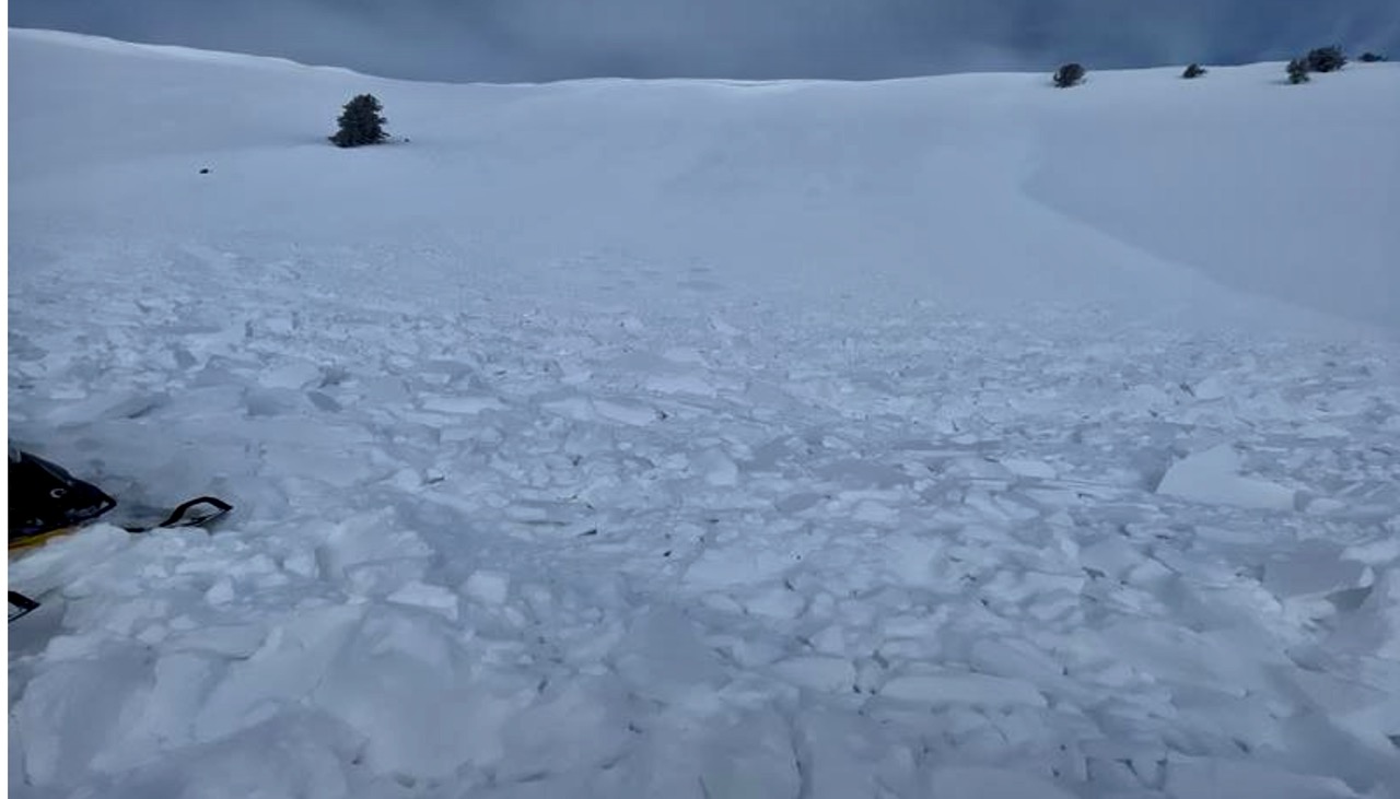
Riders remotely triggered this broad wind slab avalanche on Saturday in Christmas Tree Bowl near Naomi Peak.
A rider triggered this small avalanche of wind-drifted snow in Miller Bowl near Tony Grove Lake on Saturday.
General Announcements
  • Please submit your observations from the backcountry HERE.
  • For a list of avalanche classes from the Utah Avalanche Center go HERE
  • For information on where you can ride your sled or snow-bike, check out this map of the winter travel plan for the Logan and Ogden Ranger Districts HERE, and a close up of the Tony Grove and Franklin Basin Areas HERE.
This forecast is from the U.S.D.A. Forest Service, which is solely responsible for its content. This forecast describes general avalanche conditions and local variations always occur.