Forecast for the Logan Area Mountains

Toby Weed
Issued by Toby Weed for
Thursday, March 9, 2023
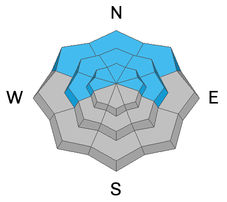
Elevated avalanche conditions exist and the danger is MODERATE on backcountry slopes steeper than 30°. People are likely to trigger small soft slab or loose avalanches of storm snow at all elevations, and isolated avalanches failing on a buried persistent weak layer are possible. Areas with CONSIDERABLE danger probably exist on drifted upper elevation slopes facing northwest through southeast, where soft slab avalanches 1 to 2 feet deep of wind drifted storm snow are likely for people to trigger.
*Err on the side of caution at upper elevations. Evaluate snow and terrain carefully.*

Tonight, heavy snowfall and rain, warming temperatures, and increasingly strong winds from the southwest will elevate the backcountry avalanche danger significantly.
Low
Moderate
Considerable
High
Extreme
Learn how to read the forecast here
Special Announcements
To help you safely enjoy the backcountry, the UAC team is constantly evaluating and implementing new programs and technologies. Donate to the Spring Campaign to help our team implement innovative tools and better provide you with the information you rely on.
Weather and Snow
Several inches of very light powder fell overnight across the zone and we'll find classic Utah cold smoke powder in the backcountry in the Bear River Range today. Even so, caution is advised becuase avalanches are possible on steep slopes at all elevations and likely in drifted upper elevation terrain. Last week people remotely triggered a few large avalanches on drifted slopes. Huge cornices formed with the recent storms posing a significant risk, and heavy snow and drifting continues to increase the load on slopes with and without buried persistent weak layers. Today, soft wind slab and loose avalanches of storm snow are most likely, but people could also still trigger large cornice falls, or isolated 1' to 3' thick slab avalanches failing on a buried persistent weak layer.
The cold temperatures are keeping the snow nice and soft, and we've been finding fantastic powder riding at all elevations on shady slopes facing the north side of the compass. Today's fresh powder snow will be pretty light and fluffy.

The 8400' Tony Grove Snotel reports 15" of light new snow containing 0.7" SWE. It's 15° F this morning, and there is 140 inches of total snow. The wind is currently blowing from the southwest around 18 mph at the 9700' CSI Logan Peak weather station.
Here is the NWS point forecast for high elevations in the Central Bear River Range:
Today: A 20 percent chance of snow before 8am. Mostly cloudy, then gradually becoming sunny, with a high near 29. Wind chill values as low as -1. Southwest wind 10 to 15 mph.
Tonight: Snow after 11pm. The snow could be heavy at times. Patchy blowing snow after 11pm. Temperature falling to near 19 by 8pm, then rising to around 28 during the remainder of the night. Wind chill values as low as 1. Windy, with a south southwest wind 10 to 20 mph increasing to 29 to 39 mph after midnight. Winds could gust as high as 55 mph. Chance of precipitation is 90%. New snow accumulation of 4 to 8 inches possible.
Friday: Snow. The snow could be heavy at times. Patchy blowing snow before 11am. High near 37. Windy, with a southwest wind 36 to 41 mph, with gusts as high as 55 mph. Chance of precipitation is 100%. New snow accumulation of 8 to 12 inches possible.
We could see a bit of a break and a bit of sun over the weekend, and it looks like another Pacific storm early next week around Tuesday.
Recent Avalanches
  • It has been quiet in the Logan Zone for the last couple days, with no new avalanches reported since the weekend storm.
  • Last week was quite active in the Logan Zone, with a few close calls and new avalanches reported almost every day. For a list of avalanches in the Logan Zone go HERE
  • It was a bit more active in the Wasatch Range earlier this week. Find a list of all recent observations & avalanches from across Utah HERE.
Ad
Avalanche Problem #1
Wind Drifted Snow
Type
Location
Likelihood
Size
Description
Overnight winds from the southwest and west were not all that strong, averaging less than 20 mph. That's still plenty strong enough to drift the light fresh powder into stiffer slabs that may be unstable. In exposed terrain, wind slabs may have formed close to ridge lines and high in avalanche starting zones. Harder, buried wind slabs are now in many cases hidden by a few inches of powder. Avalanches of wind drifted snow, 1 to 3 feet thick, are possible in windy terrain at all elevations, but will be larger and more likely for people to trigger on upper elevation slopes. Drifting of today's fresh snow will continue to build and create new wind slabs...
  • Avoid corniced slopes and stiffer drifts on steep slopes near ridges and in and around terrain features like cliff bands, sub-ridges, mid-slope break-overs, and gully walls.
  • The overhanging cornices on the high peaks and ridges have become huge with recent storms, so its a good idea to continue to stay well away and out from under them.
  • Some old wind slabs formed on a sugary persistent weak layer, and some might still be triggered remotely.
Avalanche Problem #2
New Snow
Type
Location
Likelihood
Size
Description
  • People are likely to trigger shallow soft slab or loose avalanches of storm snow on slopes steeper than 30° at all elevations.
  • Strong spring sun could moisten the snow surface and cause potential for loose wet avalanches in sunny terrain.
Avalanche Problem #3
Persistent Weak Layer
Type
Location
Likelihood
Size
Description
The Persistent Weak Layer problem is widely scattered across terrain, where thin layers of sugary faceted snow exist only in some areas, but on most aspects. At lower elevations in the Logan Zone layers of sugary faceted snow are more widespread in areas with shallower snow cover (<4') and perhaps more prevalent on northerly facing slopes. Thin layers of weak snow also often form above or between sun crusts, and some recent avalanches have failed on sunny east and southeast facing slopes.
  • Avalanches failing on a persistent weak layer might be triggered remotely or from a distance.
General Announcements
  • Please submit your observations from the backcountry HERE.
  • For a list of avalanche classes from the Utah Avalanche Center go HERE
  • For information on where you can ride your sled or snowbike, check out this map of the winter travel plan for the Logan and Ogden Ranger Districts HERE, and a close up of the Tony Grove and Franklin Basin Areas HERE.
This forecast is from the U.S.D.A. Forest Service, which is solely responsible for its content. This forecast describes general avalanche conditions and local variations always occur.