Forecast for the Logan Area Mountains

Toby Weed
Issued by Toby Weed for
Wednesday, March 9, 2022
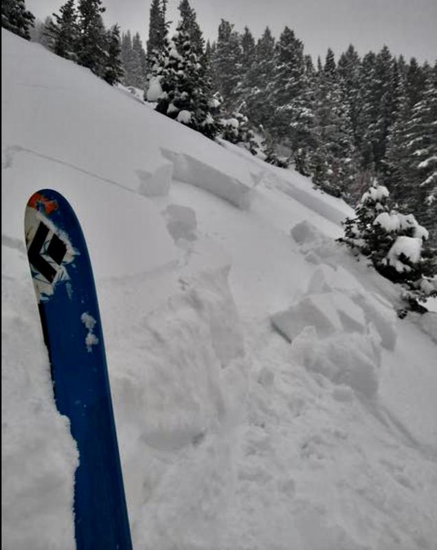
Heavy snow and drifting overloaded slopes with a buried persistent weak layer and created HIGH avalanche danger at upper and mid elevations on slopes facing the northern half of the compass. In these areas, people are likely trigger dangerous 1 to 3 foot deep slab avalanches failing on a buried layer of faceted snow. Large, long running natural avalanches are possible, especially during periods of particularly heavy snowfall. Dangerous avalanche conditions and CONSIDERABLE danger exist on many slopes and at all elevations. Natural avalanches are possible and people are likely to trigger soft slab avalanches of fresh wind drifted snow in exposed terrain and loose dry avalanches of storm snow in sheltered terrain.

People should avoid travel in avalanche terrain today. Stay off of and out from under slopes steeper than 30°. Avoid obvious and historic avalanche paths and run-out zones.
Low
Moderate
Considerable
High
Extreme
Learn how to read the forecast here
Avalanche Warning
A powerful winter storm has created very dangerous avalanche conditions in the backcountry. The avalanche danger is HIGH.
  • In effect from 6 AM MST this morning to 6 AM MST Thursday
  • For the mountains of Northern Utah, including the Wasatch Range, Western Uintas, and the Bear River Range.
  • Heavy snowfall and blowing snow overloaded slopes with buried persistent weak layers and created widespread areas of unstable snow.
  • Human triggered and natural avalanches are likely. People should avoid travel in avalanche terrain today.
Special Announcements
Head's up! Need a refill for your airbag canister? Arva and Al's will be doing a one night “Free Refills” for any brand of refillable air canister on Friday, March 11 from 6-8PM. Canisters can be dropped off before the event also.
Thanks to the generous support of our local resorts and Ski Utah, discount lift tickets are now available. Support the UAC while you ski at the resorts this season. Tickets are available HERE.
Weather and Snow
The National Weather Service has continued a Winter Storm Warning for our area, with heavy snowfall expected to taper off today. Copious heavy snow and drifting from fairly strong west winds overloaded slopes with buried persistent weak layers consisting of sugary faceted snow. Very dangerous avalanche conditions exist on many slopes facing the northern half of the compass, and natural avalanches are probably occurring in some areas this morning. The avalanche danger is HIGH, large and long-running natural avalanches are possible, and people are likely to trigger dangerous avalanches if they venture into avalanche terrain.
A skier triggered this eye opening slab avalanche yesterday evening in Providenc Canyon, as the slab finally became cohesive enough to fail on a widespread buried persistent weak layer.
This is from Steep Hollow Monday, (3-7-2022 not 3-6)

The 8400' Tony Grove Snotel reports 19°F this morning, and about 14 inches of new snow, with 1.7" SWE mostly from overnight. There is 79 inches of total snow at the site, with 88% of normal SWE for the date. Winds out of the west-southwest are blowing about 27 mph with gusts in the 50 mph range at the 9700' CSI Logan Peak weather station. It is snowing again this morning at Beaver Mountain!

  • The National Weather Service has continued a Winter Storm Warning. Expect periods of heavy snow, and 2 to 4 inches of additional accumulation is expected on upper elevation slopes today. Northwest winds will decrease a bit, and temperatures at 8500' are expected to drop around 11°F.
  • Clearing is expected tonight, with temperatures dropping to around -7°F, and with 10 to 15 mph wind from the north-northeast, wind chill values will be as low as -17°F.
  • Nice, sunny and cold weather, with moderate north-northwest wind is expected on Thursday.
Recent Avalanches
  • Parties in the Logan Zone reported numerous red flags in the backcountry yesterday, including widespread audible collapsing and cracking.
  • A skier triggered a scary slab avalanche that failed on a sugary persistent weak layer yesteday evening in the the Dog Leg avalanche path in Providence Canyon.

Check out all the recent backcountry observations and avalanche reports from across Utah HERE
Ad
Avalanche Problem #1
Persistent Weak Layer
Type
Location
Likelihood
Size
Description
The fresh snow is creating a more cohesive slab on widespread preexisting layers of very weak faceted snow. It's hard to say, but in some areas the overload of heavy new snow could be enough to activate these layers. On slopes facing the north half of the compass that picked up significant accumulation, people are likely to trigger soft slab avalanches failing on a buried persistent weak layer. I triggered a couple spooky, pretty good sized audible collapses Sunday and a couple parties reported triggering collapses yesterday.
  • Avalanches could be triggered remotely or from a distance.
  • Collapsing and cracking are red flags indicating unstable snow and a persistent weak layer.
Avalanche Problem #2
New Snow
Type
Location
Likelihood
Size
Description
Small soft slab and loose avalanches of storm snow are likely for people to trigger on upper and mid elevation slopes steeper than 30° today. Natural avalanches of storm snow are likely, especially during periods of particularly heavy snowfall.

Loose dry avalanches (or sluffs) of fresh snow are likely in sheltered terrain at all elevations on very steep slopes. When the intense March sun popps out it will moisten the fresh snow surface and it could make the surface snow sticky and prone to sluffing. On sustained slopes, sluffs could pile up deeply, especially in terrain traps like gullies, sinks, and benches.
  • Manage loose avalanches by staying out of constricting terrain, like drainage gullies, and moving out of the fall line so you don't get caught by your own sluff.
  • Avoid being caught and pulled into terrain traps below you like trees, gullies, or benches.
Avalanche Problem #3
Wind Drifted Snow
Type
Location
Likelihood
Size
Description
Last night's westerly winds were plenty strong enough to create significant drifts and soft slabs up to a couple feet deep. Drifting is overloading slopes with buried persistent weak layers and increasing the depth of a the developing slab layer. Avalanches of wind drifted snow are possible on slopes at all elevations, but are most likely at upper elevations on northwest through east facing slopes.
Additional Information
  • Now is a great time to practice your avalanche rescue skills. Thanks to the generous support of Northstar, the Franklin Basin Beacon Training Park is up and running. The park is located directly west of the parking lot and is open for anyone to use. All you need is your beacon and probe. Please do not dig up the transmitters.
  • Always follow safe backcountry travel protocols. Go one person at a time in avalanche terrain, while the rest of your party watches from a safe area. (practice anytime while traveling on or under backcountry slopes steeper than 30°)
  • Check your avalanche rescue equipment, change your batteries, and practice often with your backcountry partners.
    Check slope angles, and to avoid avalanche terrain stay off of and out from under slopes steeper than 30° and adjacent slopes. Video Here
General Announcements
Special thank you to Polaris and Northstar...Video Here
Who's up for some free avalanche training? Get a refresher, become better prepared for an upcoming avalanche class, or just boost your skills. Go to https://learn.kbyg.org/ and scroll down to Step 2 for a series of interactive online avalanche courses produced by the UAC.
  • Check out all the upcoming education classes and clinics HERE.
  • Please submit your observations from the backcountry HERE.
This information does not apply to developed ski areas or highways where avalanche control is normally done. This forecast is from the U.S.D.A. Forest Service, which is solely responsible for its content. This forecast describes general avalanche conditions and local variations always occur.