Forecast for the Logan Area Mountains

Toby Weed
Issued by Toby Weed for
Tuesday, March 8, 2022
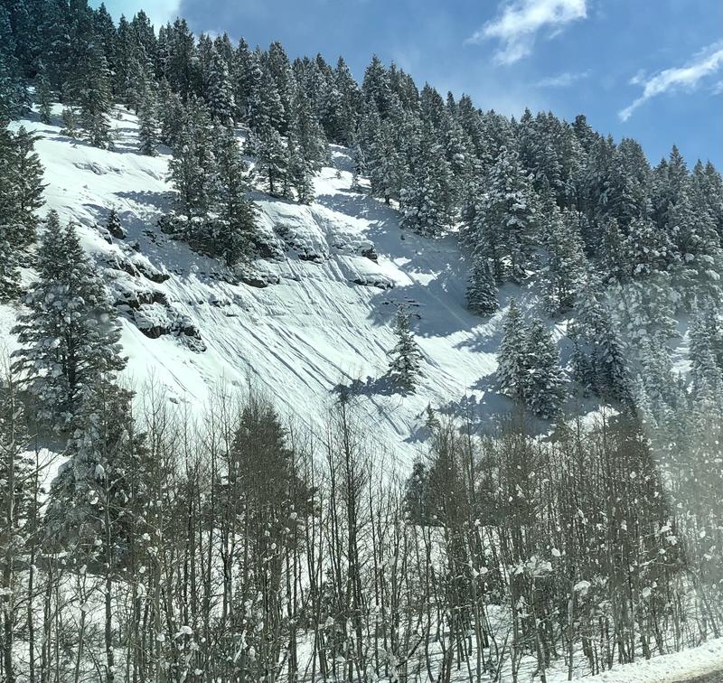
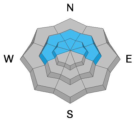
Heavy snow and drifting today will overload slopes with a buried persistent weak layer and create CONSIDERABLE avalanche danger at upper and mid elevations on slopes steeper than 30° facing the northern half of the compass. In areas that receive significant accumulations today, people might trigger a dangerous 1 to 2 foot deep slab avalanche failing on a buried layer of faceted snow. Natural avalanches are possible during periods of particularly heavy snowfall, and people are likely trigger soft slab and loose dry avalanches of storm snow.
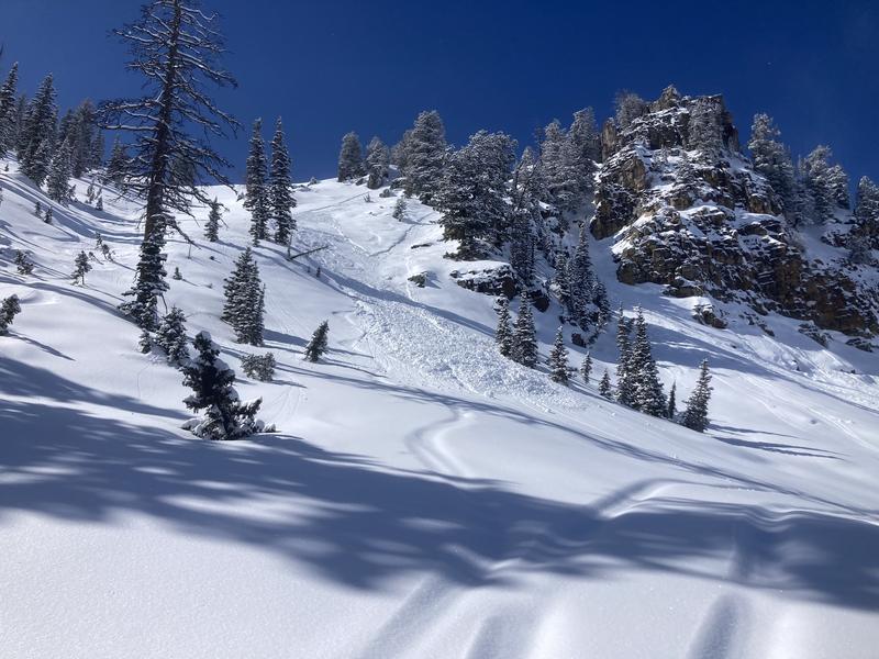
Continuing heavy snowfall and drifting from west winds could cause the avalanche danger to rise to HIGH tonight, with large and long-running natural avalanches possible.
Low
Moderate
Considerable
High
Extreme
Learn how to read the forecast here
Avalanche Watch
For the mountains of northern Utah a southeast Idaho, including the Bear River Range. A powerful winter storm could create very dangerous avalanche conditions in the backcountry. The avalanche danger for the warning area will likely rise to HIGH. Heavy snowfall and blowing snow will create widespread areas of unstable snow. Human triggered and natural avalanches will become likely.
People should avoid travel in avalanche terrain, and stay off and out from under slopes steeper than 30°
Special Announcements
Head's up! Need a refill for your airbag canister? Arva and Al's will be doing a one night “Free Refills” for any brand of refillable air canister on Friday, March 11 from 6-8PM. Canisters can be dropped off before the event also.
Thanks to the generous support of our local resorts and Ski Utah, discount lift tickets are now available. Support the UAC while you ski at the resorts this season. Tickets are available HERE.
Weather and Snow
The National Weather Service has issued a Winter Storm Warning for our area, with heavy snowfall and blowing snow expected today, tonight, and tomorrow. A powerful winter storm will impact the Logan Zone, bringing much needed snow and causing rising avalanche danger in the backcountry. Copious heavy snow and drifting will overload slopes with buried persistent weak layers consisting of sugary faceted snow. Dangerous avalanche conditions will develop later today as heavy snow accumulates, and natural avalanches of storm snow may occur during periods of particularly heavy snowfall. Continuing heavy snowfall tonight with significant accumulations and drifting from west winds will probably create HIGH danger, with large and long-running natural avalanches possible, so if you're planning on spending the night out, camp well away from steep terrain.
This is from Steep Hollow yesterday, (3-7-2022 not 3-6)

The 8400' Tony Grove Snotel reports 16°F this morning, and and inch of new snow. There is 66 inches of total snow at the site, with 84% of normal SWE for the date. Winds out of the west are increasing a bit and blowing about 22 mph at the 9700' CSI Logan Peak weather station. It is snowing again this morning at Beaver Mountain!

  • The National Weather Service has issued a Winter Storm Warning. Expect periods of heavy snow, and 5 to 9 inches of accumulation is expected on upper elevation slopes today. West-southwest winds will increase a bit, and high temperatures at 8500' around 21°F are expected.
  • Heavy snow will contninue tonight, with 8 to 12 inches of additional accumulation, steady temperature around 18°F, and moderately strong (snow transporting) west winds.
  • Snowfall is expected to tapper down tomorrow afternoon, with single digit temperatures and moderate northwest winds.
  • Nice, sunny and cold weather is expected on Thursday.
Recent Avalanches
People triggered a few small soft slab and loose avalanches of storm snow in the Beaver Mountain Backcountry on Sunday, and we watched a few natural loose sluffs in Beaver Canyon.

-A skier intentionally triggered a wet (moist) loose avalanche or sluff that entrained moist storm snow and piled up pretty deeply in Boiler Bowl Sunday afternoon.

Check out all the recent backcountry observations and avalanche reports from across Utah HERE
Ad
Avalanche Problem #1
Persistent Weak Layer
Type
Location
Likelihood
Size
Description
The fresh snow is creating a more cohesive slab on widespread preexisting layers of very weak faceted snow. It's hard to say, but in some areas the overload of heavy new snow could be enough to activate these layers. In some areas, on slopes facing the north half of the compass that pick up significant accumulation, people could trigger soft slab avalanches failing on a buried persistent weak layer, and this type of avalanche could become likely as a slab of more cohesive new snow builds on slopes with poor snow structure. I triggered a couple spooky, pretty good sized audible collapses Sunday.
  • Avalanches could be triggered remotely or from a distance.
  • Collapsing and cracking are red flags indicating unstable snow and a persistent weak layer.
Avalanche Problem #2
New Snow
Type
Location
Likelihood
Size
Description
Small soft slab and loose avalanches of storm snow are likely for people to trigger on upper and mid elevation slopes steeper than 30° today. Natural avalanches of storm snow are possible today and likely tonight during periods of particularly heavy snowfall.

Loose dry avalanches (or sluffs) of fresh snow entraining recrystallized or faceted snow are possible in sheltered terrain facing the northern half of the compass on very steep slopes. The intense March sun will moisten the fresh snow surface and make the surface snow sticky and prone to sluffing. On sustained slopes, sluffs could pile up deeply, especially in terrain traps like gullies, sinks, and benches.
  • Manage loose avalanches by staying out of constricting terrain, like drainage gullies, and moving out of the fall line so you don't get caught by your own sluff.
  • Avoid being caught and pulled into terrain traps below you like trees, gullies, or benches.
Additional Information
  • Now is a great time to practice your avalanche rescue skills. Thanks to the generous support of Northstar, the Franklin Basin Beacon Training Park is up and running. The park is located directly west of the parking lot and is open for anyone to use. All you need is your beacon and probe. Please do not dig up the transmitters.
  • Always follow safe backcountry travel protocols. Go one person at a time in avalanche terrain, while the rest of your party watches from a safe area. (practice anytime while traveling on or under backcountry slopes steeper than 30°)
  • Check your avalanche rescue equipment, change your batteries, and practice often with your backcountry partners.
    Check slope angles, and to avoid avalanche terrain stay off of and out from under slopes steeper than 30° and adjacent slopes. Video Here
General Announcements
Special thank you to Polaris and Northstar...Video Here
Who's up for some free avalanche training? Get a refresher, become better prepared for an upcoming avalanche class, or just boost your skills. Go to https://learn.kbyg.org/ and scroll down to Step 2 for a series of interactive online avalanche courses produced by the UAC.
  • Check out all the upcoming education classes and clinics HERE.
  • Please submit your observations from the backcountry HERE.
This information does not apply to developed ski areas or highways where avalanche control is normally done. This forecast is from the U.S.D.A. Forest Service, which is solely responsible for its content. This forecast describes general avalanche conditions and local variations always occur.