March Kicks Off Our Spring Campaign- Donate Now to Support Forecasting

Forecast for the Logan Area Mountains

Toby Weed
Issued by Toby Weed on
Friday morning, March 7, 2025
There is CONSIDERABLE avalanche danger in mid and upper-elevation terrain. Natural avalanches are possible, and people are likely to trigger loose and soft slab avalanches of storm snow up to 2 feet deep on slopes steeper than 30°.
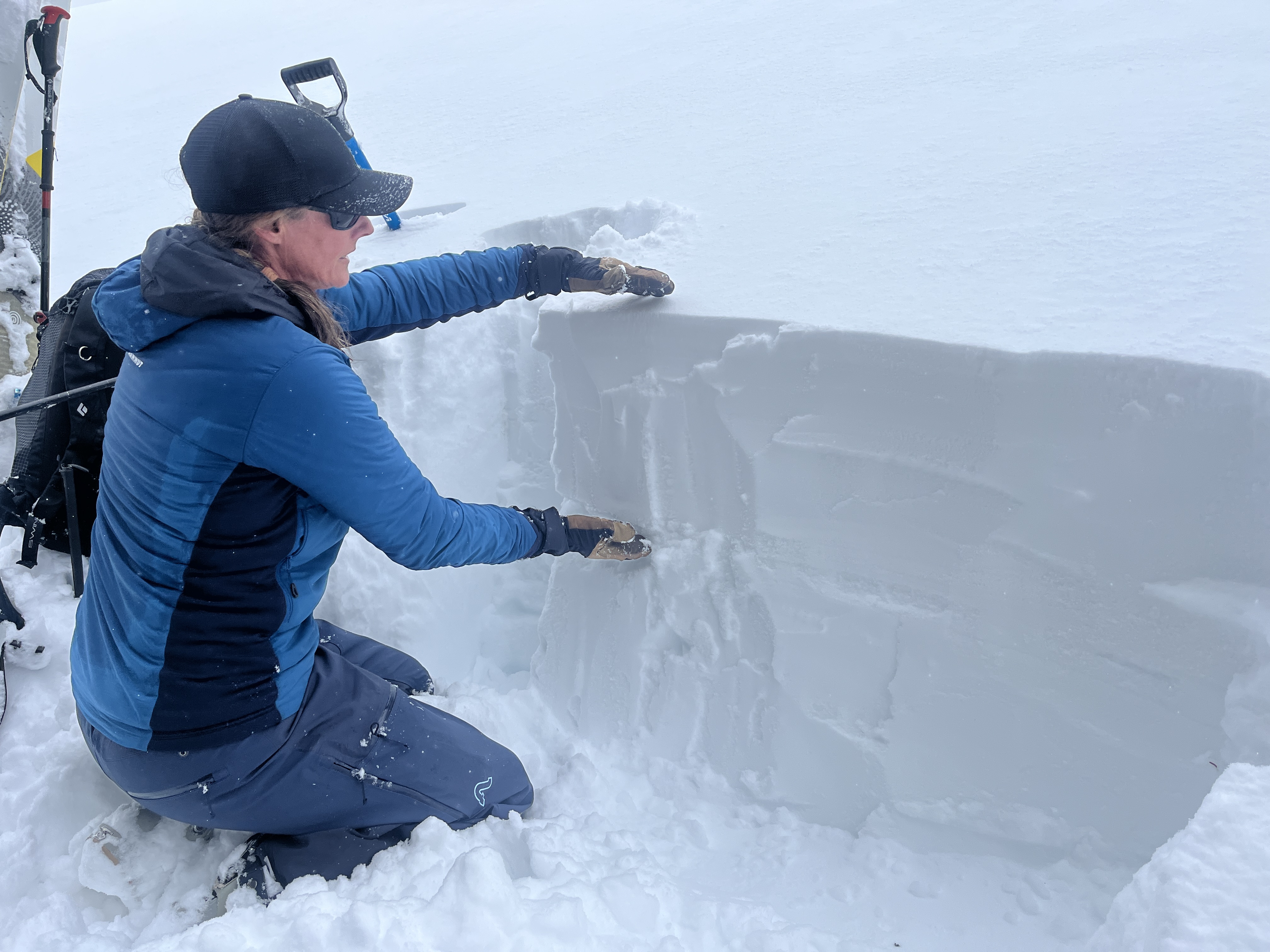
Evaluate snow and terrain carefully, make conservative choices, and continue to practice safe travel protocols. Avoid drifted slopes and large overhanging cornices.
Low
Moderate
Considerable
High
Extreme
Learn how to read the forecast here
Special Announcements
March kicks off our Spring Campaign! If everyone in Utah’s backcountry community donates the cost of something they regularly enjoy on an adventure—like a dawn patrol burrito, a backpack snack, or post-ride trailhead drinks—we could fund not just one but two forecasters for the entire season! Donate here.
Weather and Snow
Yesterday, the thick new snow was too deep in the Tony Grove Area to ski anything not steep enough to slide, and knee-deep trail breaking was arduous. But, we found excellent and super fun powder riding conditions in the meadows and on safe slopes less than 30° in slope steepness. Paige said she had more fun on the Ski-Doo than she's ever had before riding in powder.
No slab avalanches were reported yesterday, but we observed evidence of numerous natural loose avalanches of storm snow coming off the cliffs and steep slopes above Tony Grove Lake. We watched a few occurring during periods of particularly heavy snowfall. We also noticed several significant loose wet avalanches that ran during the day into the Logan River from the River Chutes below Temple Fork.
Soft slab avalanches of storm snow are a concern today in upper and mid-elevation terrain. We found a weak layer of graupel and rimed stellar snow flakes capping a thin melt-freeze crust from last week's warm temperatures. People are likely to trigger slab avalanches of storm snow up to 2 feet deep, especially on steep slopes where the new snow was drifted by moderate winds during the storm.

The Tony Grove Snotel at 8400 feet reports 7 inches of new snow in the last 24 hours, with 15 inches from the storm, containing 2 inches of SWE (snow water equivalent). It's 20° F, with 102 inches of total snow and the station sits at 112% of normal SWE for the date. There's 6 inches of new snow from yesterday and overnight, with 14 inches storm total at the Card Canyon weather station at 8800 feet. It's 16° F, and there's 75 inches of total snow.
At 9700 feet at CSI's Logan Peak Wx station, winds are blowing 11 to 15 mph from the northwest and it's 13° F. It appears to be a bit more windy in the northern part of the zone. On Paris Peak at 9500 feet, it's 10° F, with winds blowing 17 to 25 mph from the north.

The National Weather Service continued a Winter Storm Warning through this evening, but snowfall will taper off in the Logan Zone this morning. Light snow is falling this morning, but should wind down soon. It'll be mostly cloudy today, with high temperatures at 8500 feet around 28° F, and 8 to 13 mph winds from the north veering from the east this morning. Mostly cloudy skies will clear tonight, with a low temperature around 13° F and 8 to 13 mph wind from the north. Bluebird conditions with plenty of sun and warming temperatures are expected this weekend. Tomorrow will be sunny with high temperatures around 32° F and 6 to 9 mph wind from the north. It will be sunny and warmer still on Sunday, with upper elevation temperatures approaching 40° F.

For more information, visit the UAC weather page here: Weather - Utah Avalanche Center
For Logan-specific weather, go here: Logan Mountain Weather - Utah Avalanche Center
Recent Avalanches
Plenty of wet loose avalanches were visible in Logan Canyon yesterday, running into the Logan River below Temple Fork. There was lots of loose avalanche activity at upper elevations as well. We observed numerous loose dry avalanches of sluffs coming off the cliffs and steep slopes above Tony Grove Lake during periods of particularly heavy snowfall yesterday. The last reported large natural slab avalanche running on a buried PWL occurred on February 25.
Read about all avalanches and observations HERE.
Ad
Avalanche Problem #1
New Snow
Type
Location
Likelihood
Size
Description
Natural avalanches are possible, and people are likely to trigger loose and soft slab avalanches of storm snow up to 2-feet-deep on drifted mid and upper-elevation slopes steeper than 30°.
Wet avalanches of storm snow are also possible in steep low-elevation terrain, but cooler temperatures today should help to set up the saturated snow. Many slopes were bare of snow or had only very shallow coverage before the storm. The rain-snow line descended to the valley floor overnight, but plenty of rain fell on lingering low elevation snow yesterday, and the snow at low elevations is saturated and loose.
Avalanche Problem #2
Persistent Weak Layer
Type
Location
Likelihood
Size
Description
While unlikely, the new load may reawaken a persistent weak layer buried 3 to 4 feet deep, and dangerous hard slab avalanches are possible, especially in outlying rocky terrain with generally shallow snow cover. The last reported avalanches failing on this PWL occurred on January 25 and were triggered by cornice falls.
It's a good idea to stick to terrain with deep snow and slopes that are not threatened by overhanging cornices, but the best way to avoid any chance of triggering a dangerous avalanche is to avoid being on or under slopes steeper than 30°.
Additional Information
Paige shows how much new snow accumulated yesterday in northeast facing terrain at 8800 feet in the Central Bear River Range.
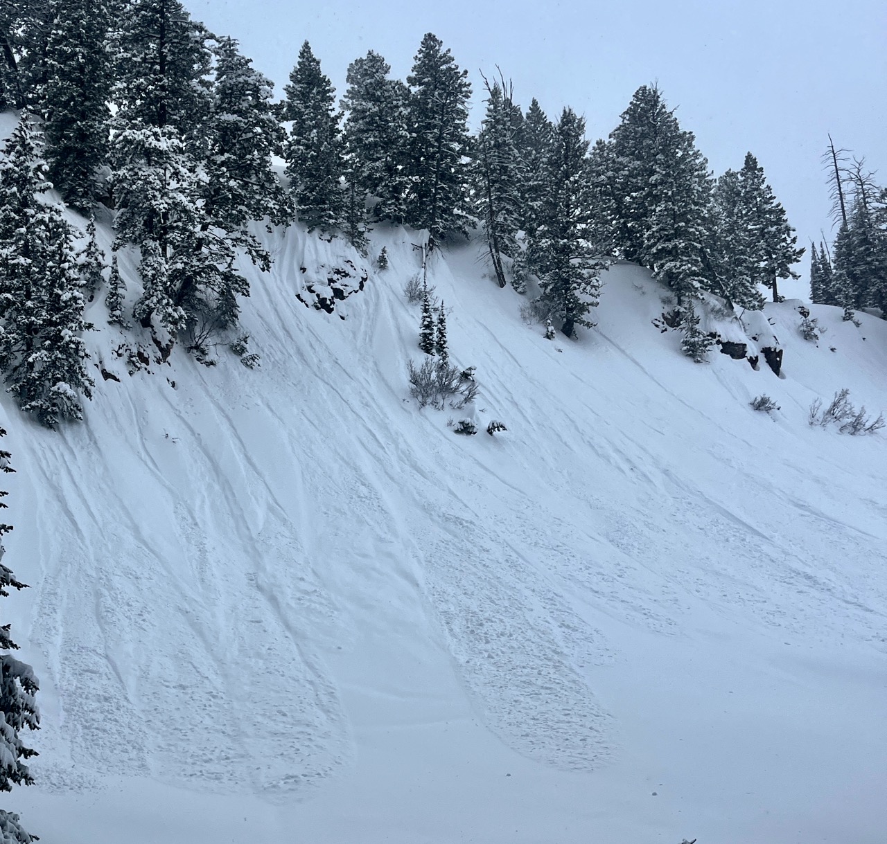
We observed numerous loose avalanches of storm snow in the steep terrain above Tony Grove Lake. These were occurring yesterday during periods of particularly heavy snowfall.
General Announcements
-National Forest Winter Recreation Travel Maps show where it's open to ride: UWCNF Logan, Ogden LRD Tony Grove, Franklin Basin CTNF Montpelier
-For all questions on forecasts, education, Know Before You Go, events, online purchases, or fundraising, call 801-365-5522.
-Remember the information you provide could save lives, especially if you see or trigger an avalanche. To report an avalanche or submit an observation from the backcountry, go HERE.
-Receive forecast region-specific text message alerts to receive messages about changing avalanche conditions, watches, and warnings. Sign up and update your preferences HERE.
-We are excited to announce the launch of our new mobile application available on both Android and IOS. Get all the information you need to plan your backcountry adventure and keep the information at the tip of your fingers while you are out. Install the Android version HERE and the IOS version HERE.

This forecast is from the U.S.D.A. Forest Service, which is solely responsible for its content. This forecast describes general avalanche conditions, and local variations always occur.