Forecast for the Logan Area Mountains

Toby Weed
Issued by Toby Weed for
Saturday, March 5, 2022
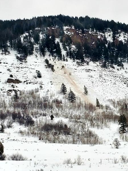
As heavy fresh snow accumulates on mountain slopes today, the backcountry avalanche danger will rise. A MODERATE danger remains this morning at mid and lower elevations, with wet avalanches possible on steep slopes with saturated snow. Significant accumulations of heavy new snow will create heightened avalanche conditions and MODERATE danger on steep upper and mid elevation slopes. Small loose and soft slab avalanches of new snow will probably become possible for people to trigger later today. Evaluate snow and terrain carefully.
Continuing accumulation tonight may produce enough load to cause dangerous avalanche conditions, and natural avalanches are possible, especially during periods of heavy snowfall.
Low
Moderate
Considerable
High
Extreme
Learn how to read the forecast here
Special Announcements
Thanks to the generous support of our local resorts and Ski Utah, discount lift tickets are now available. Support the UAC while you ski at the resorts this season. Tickets are available HERE.
Weather and Snow
The first significant snowstorm in around two months in the Logan Zone will bring significant accumulations to the mountains. This is very good news, but today's new snow will begin to overload slopes with shallowly buried persistent weak layers of sugary faceted snow. Continuing accumulations will likely cause dangerous avalanche conditions to develop in the backcountry this weekend and next week, with dangerous slab avalanches potentially failing on a buried persistent weak layer on slopes facing the northern half of the compass.

The 8400' Tony Grove Snotel reports 28°F this morning, and there is 60 inches of total snow at the site, with 84% of normal SWE for the date. Winds out of the south are blowing about 10 mph at the 9700' CSI Logan Peak weather station.

  • Expect snow in the mountains today, with 3 to 5 inches of accumulation possible. 8500' high temperatures will be around 31°F, with 10 mph west winds, veering from the east in the afternoon.
  • Snow will continue tonight, with 3 to 5 more inches of accumulation possible. Temperatures will drop to around 17°F, with 10 to 15 mph east winds.
  • Snow is likely tomorrow, with a few inches of additional accumulation possible. Expect temperatures to drop around 18°F, and southeast winds, veering from the northwest in the morning.
  • Looks like perhaps a break in the weather on Monday, but unsettled, wintry weather will continue next week. The next storm could begin to impact the zone on Tuesday.

With widespread shallowly buried persistent weak layers plaguing terrain facing the northern half of the compass at all elevations, significant accumulations of spring snow will cause the avalanche danger to rise significantly in the backcountry.
Recent Avalanches
Observers yesterday noticed a recent natural loose wet avalanche that ran off the East Banks in Logan Canyon.

Check out all the recent backcountry observations and avalanche reports from across Utah HERE
Ad
Avalanche Problem #1
Wet Snow
Type
Location
Likelihood
Size
Description
Cloud cover and cooling temperatures with today's snowstorm will probably keep a lid on wet avalanche activity, but a little bit of rain fell on the warm snow at lower and mid elevations overnight and this morning's snow in Logan is heavy and moist. So, although the threat is diminishing with cooler temperatures, wet avalanches will remain possible on very steep lower and mid elevation slopes. Although unlikely, it has been so warm that dangerous wet slab avalanches may be possible on very steep slopes with saturated weak snow as saturated snow gradually refreezes from top down.
Avalanche Problem #2
New Snow
Type
Location
Likelihood
Size
Description
Small loose and soft slab avalanches of new snow will probably become possible for people to trigger on upper and mid elevation slopes later today.

Loose dry avalanches (or sluffs) of fresh snow entraining recrystallized or faceted snow are possible in sheltered terrain facing the northern half of the compass on very steep slopes.
  • Manage loose avalanches by staying out of constricting terrain, like drainage gullies, and moving out of the fall line so you don't get caught by your own sluff.
  • Avoid being caught and pulled into terrain traps below you like trees, gullies, or benches.
Additional Information
  • Now is a great time to practice your avalanche rescue skills. Thanks to the generous support of Northstar, the Franklin Basin Beacon Training Park is up and running. The park is located directly west of the parking lot and is open for anyone to use. All you need is your beacon and probe. Please do not dig up the transmitters.
  • Always follow safe backcountry travel protocols. Go one person at a time in avalanche terrain, while the rest of your party watches from a safe area. (practice anytime while traveling on or under backcountry slopes steeper than 30°)
  • Check your avalanche rescue equipment, change your batteries, and practice often with your backcountry partners.
    Check slope angles, and to avoid avalanche terrain stay off of and out from under slopes steeper than 30° and adjacent slopes. Video Here
General Announcements
Special thank you to Polaris and Northstar...Video Here
Who's up for some free avalanche training? Get a refresher, become better prepared for an upcoming avalanche class, or just boost your skills. Go to https://learn.kbyg.org/ and scroll down to Step 2 for a series of interactive online avalanche courses produced by the UAC.
  • Check out all the upcoming education classes and clinics HERE.
  • Please submit your observations from the backcountry HERE.
This information does not apply to developed ski areas or highways where avalanche control is normally done. This forecast is from the U.S.D.A. Forest Service, which is solely responsible for its content. This forecast describes general avalanche conditions and local variations always occur.