UDOT PLANNED AVALANCHE CLOSURES!!

Forecast for the Logan Area Mountains

Toby Weed
Issued by Toby Weed for
Monday, March 25, 2019
CONSIDERABLE: Rapid solar warming will create dangerous avalanche conditions on sunny slopes today. Natural wet loose avalanches, entraining saturated new snow will become increasingly likely as slopes are warmed by the strong March sun. It is also still possible for people to trigger 1 to 2 foot deep slab avalanches failing on a buried persistent weak layer on some upper elevation slopes, especially those facing north and east. Use extra caution. Evaluate snow and terrain carefully, and make conservative decisions in the backcountry.
Low
Moderate
Considerable
High
Extreme
Learn how to read the forecast here
Special Announcements
We need your help. In an effort to increase awareness and prevent future fatalities we need to reach more people with our daily avalanche forecasts, expand the Know Before You Go program, and increase the number of on-snow avalanche courses. Please consider a donation to the UAC to help us raise $25,000 by April 8. Show your support of the UAC by making a donation at https://utahavalanchecenter.org/donate
Weather and Snow
The Tony Grove Snotel at 8400' reports about 6 inches of moist new snow, with .7" SWE in the last 24 hours. It's ?ºF this morning and there is 90" of total snow with 104% of average SWE for the date. It's 17ºF at the 9700' CSI Logan Peak weather station, and west winds are currently averaging around 20 mph. Heightened avalanche conditions exist at all elevations in the backcountry today, and rapid solar warming will likely create dangerous conditions on sunny slopes, with natural wet avalanches becoming likely on some steep slopes with midday heat.

High pressure aloft across the Great Basin will generate a substantial warming trend during the first half of the week. An active spring weather pattern will return for the latter half of the week and into the first half of the weekend. It will be sunny and increasingly warm in the mountains today, with high temperatures at 9000' expected be around 39ºF, with 7 to 11 mph south-southwest wind. It will be partly cloudy tonight with a low temperature around 25º F, and 15 mph south-southwest winds. It will be sunny and warm again tomorrow, with high temperatures expected to climb to about 42ºF, with 15 to 22 mph south-southwest wind.
Recent Avalanches
There were quite a few small triggered avalanches in the Wasatch Range yesterday, but the headlines are dominated by an accident in Cardiac Bowl, in Big Cottonwood Canyon, east of Salt Lake City. 6 people were caught and carried by a shallow but broad avalanche. The outcome could have been much worse, but 2 people were partially buried and one was injured. See Report
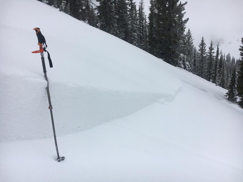
 HERE
Saturday a skier triggered a scary 1 to 2 foot deep and 150' wide avalanche running on a buried persistent weak layer near Danish Pass. The avalanche ran on a 32 degree, north-northeast facing slope at around 8800' in elevation. Report is HERE
Observers reported easily triggering several shallow soft slab and loose avalanches involving fresh storm snow at upper elevations in the Central Bear River Range on Friday.
Ad
Avalanche Problem #1
Wet Snow
Type
Location
Likelihood
Size
Description
Rapid warming from strong March sun will create dangerous wet avalanche conditions on sunny slopes, especially on those with significant recent accumulations of heavy snow. Natural wet loose avalanches are likely in sunny terrain and will entrain large piles of heavy debris on sustained slopes.
  • Avoid being on or under steep slopes with sun warmed, saturated, or sticky new snow, and stay out of possible runout gullies.
Avalanche Problem #2
Persistent Weak Layer
Type
Location
Likelihood
Size
Description
Loose sluffs and shallow soft slabs consisting of new and wind drifted snow are possible on many steep mountain slopes today. The moist new snow did not bond well with the old in some areas, and there were numerous small avalanches entraining storm snow. Watch for and avoid wind drifted snow on steep upper elevation slopes. You could trigger wind slab avalanches, 1 to 2 feet deep, and these could travel fast and far in places on a slick sun-crust from last week's warm up.
  • Use caution in upper elevation areas where drifts form, like on the lee side of major ridges and in and around terrain features like sub-ridges, gullies, scoops, tree stringers, and cliff bands.
  • Stay off and out from under large ridge top cornices, which are likely to break further back than expected and could trigger avalanches on steep slopes below.
Special caution is needed on upper elevation slopes with significant accumulations, especially on north facing slopes where the old snow was plagued by weak sugary surface snow or surface hoar. Saturday's avalanche near Danish Pass involved older snow, failing on a persistent weak layer consisting of surface hoar and small-grained sugary near surface facets. It's possible people could trigger similar avalanches at upper elevations today. Some avalanches failing on a buried persistent weak layer could be triggered remotely or from a distance.
This photo shows flattened surface hoar feathers on the bed surface of the Danish Pass Avalanche, 3/23/19 (R. Choi)
Additional Information
I will update this forecast Wednesday morning.
General Announcements
The new weather station at the WSU Bloomington Canyon Yurt is up and running. Data available HERE
Now is a great time to practice companion rescue techniques with your backcountry partners. You should check out and use the new Avalanche Beacon Training Park we set up at the Franklin Basin trailhead. Special thanks to Northstars Ultimate Outdoors, USU Outdoor Program, and Beaver Mountain Ski Patrol for helping us to make this possible.
The Beaver Mountain Backside is the backcountry, and it is avalanche terrain. Same goes for the steep rocky terrain adjacent to Cherry Peak Resort. If you leave a ski area boundary, you and your partners should carry and practice with avalanche rescue equipment and follow safe backcountry travel protocols.
Check out the improved weather links, road conditions, and weather links for each forecast region on the new UAC IOS App. Do you use the NOAA point forecast? If so, now you can bookmark your favorite weather locations in "My Weather" in the App. HERE
Are you new to the backcountry or looking to refresh your skills? The UAC has released a free 5-part avalanche skills eLearning series. HERE
If you would like to get the daily advisory by email you subscribe HERE.
Support the UAC through your daily shopping. When you shop at Smith's, or online at REI, Backcountry.com, Patagonia, NRS, Amazon, eBay by clicking on these links, they donate a portion of your purchase to the UAC. If you sell on eBay, you can have your See our Affiliate Page for more details on how you can support the UAC when you shop
Remember your information can save lives. If you see anything we should know about, please help us out by submitting snow and avalanche observations. HERE You can call us at 801-524-5304, email by clicking HERE, or include #utavy in your Instagram.
This forecast is from the U.S.D.A. Forest Service, which is solely responsible for its content. The forecast describes general avalanche conditions and local variations always occur.