Forecast for the Logan Area Mountains

Toby Weed
Issued by Toby Weed for
Tuesday, March 21, 2023
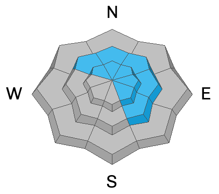
Heightened avalanche conditions and MODERATE danger exist in the backcountry, and people could trigger soft slab or loose avalanches of storm snow on slopes steeper than 30°. Avalanches are more likely and areas with CONSIDERABLE danger can be found on drifted upper elevation slopes facing northwest through southeast. Human triggered cornice falls and 1' to 2' thick slab avalanches of wind drifted snow are likely and natural avalanches are possible.
Continue to stay well away from and out from under those big cornices. Make conservative decisions and evaluate snow and terrain carefully.
Low
Moderate
Considerable
High
Extreme
Learn how to read the forecast here
Special Announcements
Please consider donating to the spring campaign to help our team implement innovative tools and better provide you with the information you rely on.
Weather and Snow
The 8400' Tony Grove Snotel reports 6 inches of new snow in the last 24 hours. It's 19° F this morning, and there is 131 inches of total snow. The wind is blowing from the west-southwest around 20 mph this morning at the 9700' CSI Logan Peak weather station.

Here is the NWS point forecast (36 hrs) for high elevations in the Central Bear River Range:
Today: Partly sunny, with a high near 29. Wind chill values as low as zero. West southwest wind 9 to 15 mph becoming southeast in the afternoon.
Tonight: Snow showers. The snow could be heavy at times. Patchy blowing snow after midnight. Low around 19. Wind chill values as low as 5. East southeast wind around 18 mph becoming south southwest after midnight. Chance of precipitation is 90%. New snow accumulation of 4 to 8 inches possible.
Wednesday: Snow showers. The snow could be heavy at times. Patchy blowing snow. High near 28. Wind chill values as low as 7. Breezy, with a south southwest wind 14 to 23 mph. Chance of precipitation is 100%. New snow accumulation of 8 to 12 inches possible.

The National Weather service has issued a Winter Weather Advisory for the Logan Zone, and I expect more dangerous avalanche conditions to develop overnight and tomorrow. Snow showers and periods of heavier snowfall will continue through the week...
Recent Avalanches
  • Skiers Saturday encountered the extensive debris from a recent large natural cornice fall avalanche in Rattlesnake Canyon in the Wellsville Mountain Wilderness. report HERE
  • Large natural wet avalanches were widespread at lower elevations in the Logan Zone Wednesday, spawned by warmth and a significant amount of rain-on-snow.
  • For a list of recent avalanches in the Logan Zone go HERE
  • It was a bit more active in the Wasatch Range in the last few days due to wind drifted snow. Find a list of all recent observations & avalanches from across Utah HERE.
Ad
Avalanche Problem #1
New Snow
Type
Location
Likelihood
Size
Description
People could trigger soft slab or loose avalanches of storm snow today on slopes steeper than 30° at mid and upper elevations.
Avalanches are less likely down low today, but the snow on some slopes could soften up and become unstable with solar warming and seasonal warmth. The snow on lower elevation slopes facing northwest through east is quite a bit deeper than it normally is this time of year and avalanches are possible in steep terrain...
Avalanche Problem #2
Wind Drifted Snow
Type
Location
Likelihood
Size
Description
Today's moderate winds are blowing from the west-southwest, plenty strong enough to drift yesterday's fresh snow. Expect to fine sensitive cornices and fresh wind slabs in upper elevation avalanche starting zones.
  • Avalanches of wind drifted snow, large cornice falls, or 1 to 2' thick wind slabs, are possible for people to trigger in windy terrain at upper elevations.
  • Avoid corniced slopes and stiffer drifts on steep slopes near ridges and in and around terrain features like cliff bands, sub-ridges, mid-slope break-overs, and gully walls.
  • The overhanging cornices on the high peaks and ridges have become huge with recent storms, so its a good idea to continue to stay well away and out from under them.
  • Avalanches of wind drifted snow failing on a persistent weak layer buried 1 to 3 feet deep are unlikely yet possible, and some still might be triggered remotely or from a distance.
Additional Information
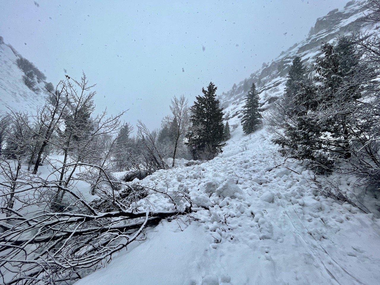
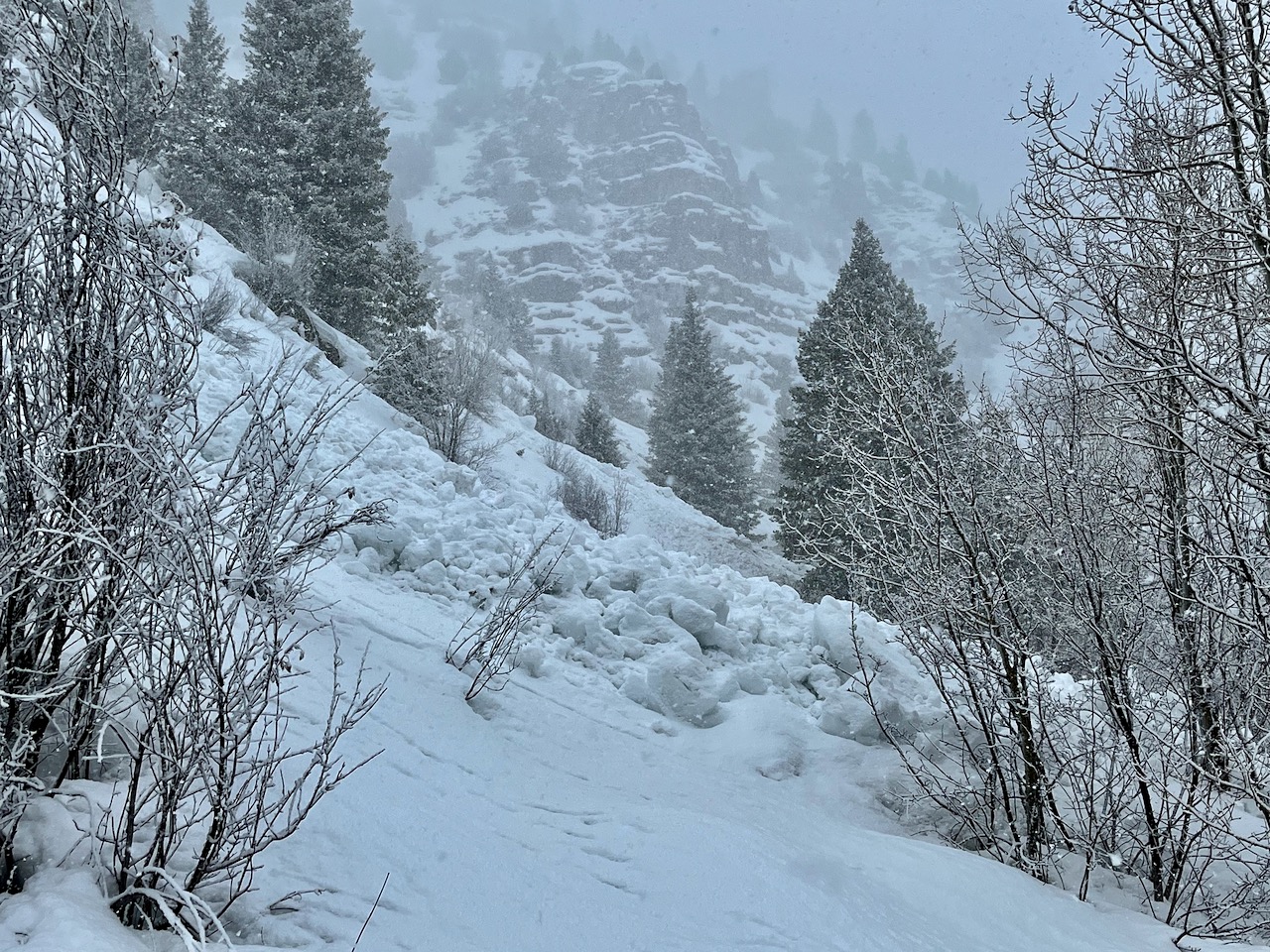
Large natural wet avalanches occurred at lower elevations last week. I looked at extensive debris in Right Hand Fork and Cowley Canyon just above Camp Lomia, where avalanches crossed the popular forest road...
General Announcements
  • Please submit your observations from the backcountry HERE.
  • For a list of avalanche classes from the Utah Avalanche Center go HERE
  • For information on where you can ride your sled or snowbike, check out this map of the winter travel plan for the Logan and Ogden Ranger Districts HERE, and a close up of the Tony Grove and Franklin Basin Areas HERE.
This forecast is from the U.S.D.A. Forest Service, which is solely responsible for its content. This forecast describes general avalanche conditions and local variations always occur.