Forecast for the Logan Area Mountains

Toby Weed
Issued by Toby Weed for
Sunday, March 19, 2023
The snow is generally stable in the backcountry, avalanches are unlikely, and the danger is mostly LOW. Even so, areas with MODERATE danger exist, and people might trigger large cornice falls or 1' to 2' deep slab avalanches of wind drifted snow on isolated upper elevation slopes. The Pacific atmospheric river returns tonight, and heavy snowfall, rain, and wind will elevate backcountry avalanche conditions.
Use normal caution.
Low
Moderate
Considerable
High
Extreme
Learn how to read the forecast here
Special Announcements
Please consider donating to the spring campaign to help our team implement innovative tools and better provide you with the information you rely on.
Weather and Snow
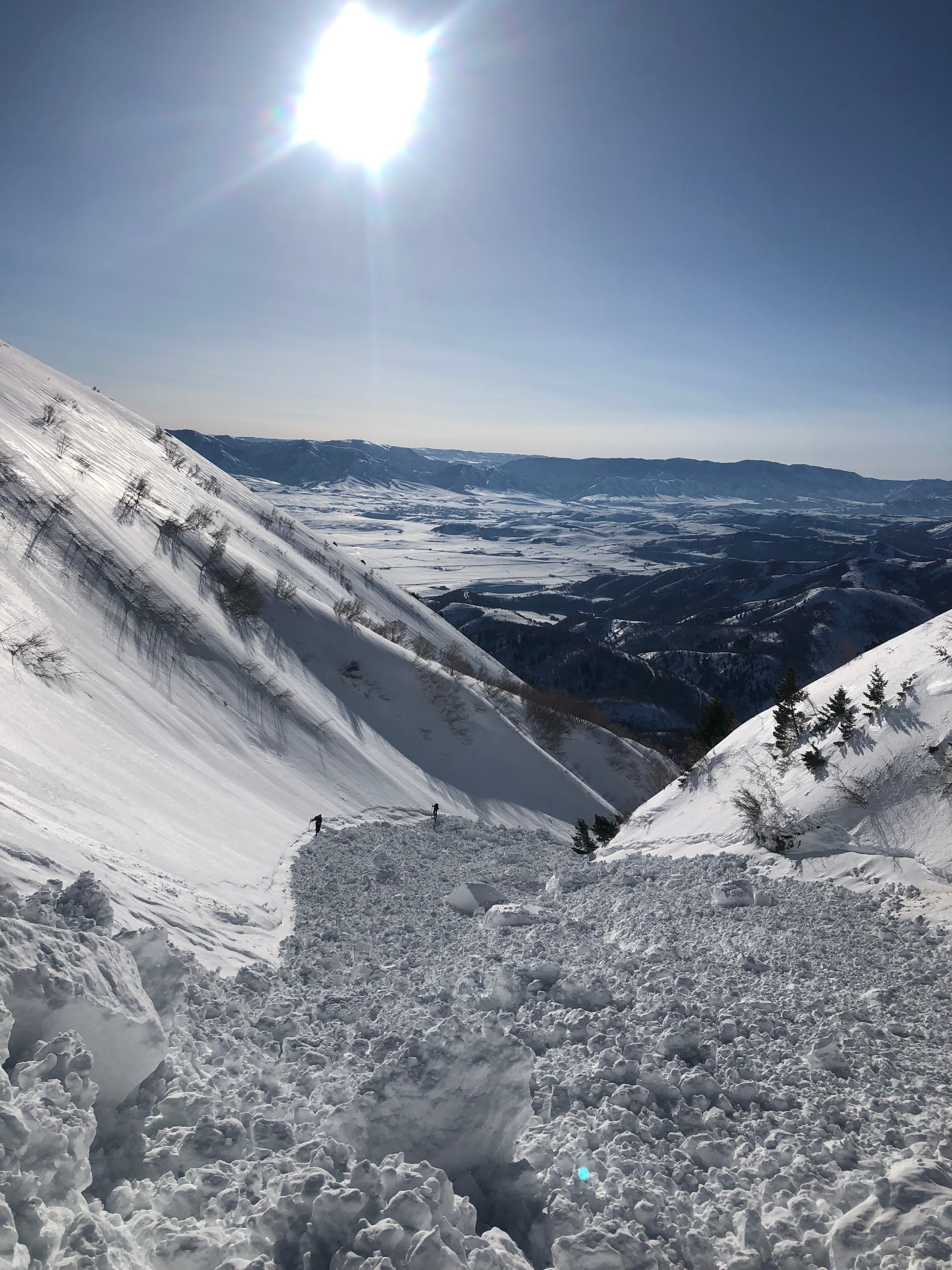
We've been able to find decent powder up high, with a solid melt-freeze or rain-crust on all aspects below about 7500'. Smooth spring corn snow conditions have been reported. Expect to still find areas with elevated conditions in drifted high terrain, with large cornice falls and avalanches of wind drifted snow possible. Winds blowing from the south last night may have drifted snow into lee slope avalanche starting zones, overloading hard wind slabs and creating fresh ones. People should continue to stay well away from and out from under huge overhung cornices on the major ridge-lines.

The 8400' Tony Grove Snotel reports 20° F this morning, and there is 127 inches of total snow. The wind is blowing from the south 25 to 30 mph this morning at the 9700' CSI Logan Peak weather station.

Here is the NWS point forecast (36 hrs) for high elevations in the Central Bear River Range:
Today: Partly sunny, with a high near 32. Wind chill values as low as 2. Southwest wind around 14 mph.
Tonight: Snow showers, mainly after midnight. The snow could be heavy at times. Low around 22. Wind chill values as low as 10. South southwest wind around 15 mph. Chance of precipitation is 80%. New snow accumulation of 4 to 8 inches possible.
Monday: Snow showers. The snow could be heavy at times. High near 30. South southwest wind 13 to 18 mph. Chance of precipitation is 100%. New snow accumulation of 6 to 10 inches possible.

The National Weather Service has issued a Winter Storm Warning for the Logan Zone for tonight through tomorrow night. The storm will elevate the avalanche danger, and dangerous conditions are likely to develop in drifted terrain once again.
Recent Avalanches
  • Skiers yesterday encountered the extensive debris from a recent large natural cornice fall avalanche in Rattlesnake Canyon in the Wellsville Mountain Wilderness. report HERE
  • Large natural wet avalanches were widespread at lower elevations in the Logan Zone Wednesday, spawned by warmth and a significant amount of rain-on-snow.
  • For a list of recent avalanches in the Logan Zone go HERE
  • It was a bit more active in the Wasatch Range in the last few days due to wind drifted snow. Find a list of all recent observations & avalanches from across Utah HERE.
Ad
Avalanche Problem #1
Cornice
Type
Location
Likelihood
Size
Description
Avalanches of wind drifted snow, large cornice falls, or 1 to 2' thick wind slabs, are possible for people to trigger in isolated windy terrain at upper elevations.
  • Avoid corniced slopes and stiffer drifts on steep slopes near ridges and in and around terrain features like cliff bands, sub-ridges, mid-slope break-overs, and gully walls.
  • The overhanging cornices on the high peaks and ridges have become huge with recent storms, so its a good idea to continue to stay well away and out from under them.
  • Avalanches of wind drifted snow failing on a persistent weak layer buried 1 to 3 feet deep are unlikely yet possible, and some still might be triggered remotely or from a distance.
Avalanche Problem #2
Wet Snow
Type
Location
Likelihood
Size
Description
Wet avalanches are unlikely today, but may be possible when the saturated snow softens up during the heat of midday, especially in sunny terrain. Temperatures are warming with the southerly winds, and incoming clouds could cause some green-housing in sheltered terrain.
More than normal snow cover exists even at very low elevations, and snow becomes unstable on steep slopes as it is saturated and loosened up in the meltdown.
Additional Information

A recent large natural cornice fall avalanche in Rattlesnake Canyon in the Wellsville Mountain Wilderness ran quite a distance and put a large pile of debris in the main gully.
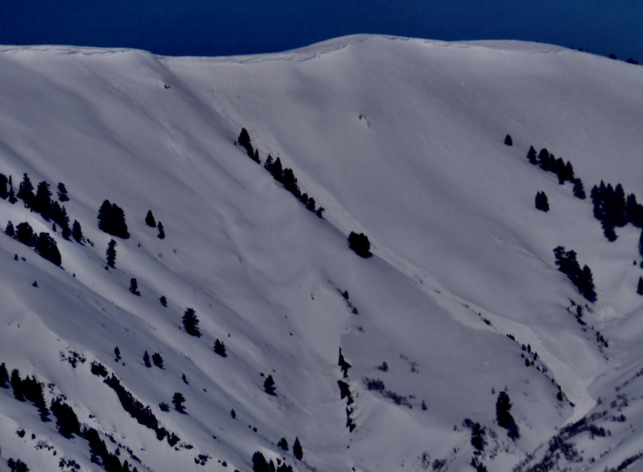
There are very large cornices in the Logan Zone this spring, and this is a good reason to stay well away from and out from under them for a while. Cornices can fail way back from the edge, on seemingly flat ridgelines, and they can trick and roll even the most experienced people. Natural cornice falls like this one are most likely during storms with significant ongoing drifting or when warm temps and spring sun cause rapid warming, but they can occur at anytime.....
General Announcements
  • Please submit your observations from the backcountry HERE.
  • For a list of avalanche classes from the Utah Avalanche Center go HERE
  • For information on where you can ride your sled or snowbike, check out this map of the winter travel plan for the Logan and Ogden Ranger Districts HERE, and a close up of the Tony Grove and Franklin Basin Areas HERE.
This forecast is from the U.S.D.A. Forest Service, which is solely responsible for its content. This forecast describes general avalanche conditions and local variations always occur.