Donate to the 2024 Spring Campaign to help rebuild the UAC website.

Forecast for the Logan Area Mountains

Toby Weed
Issued by Toby Weed for
Monday, March 18, 2019
MODERATE: The snow is stable and the danger low on most slopes this morning. Daytime solar warming and possible green-housing from high cloud cover will cause increasing danger and heightened avalanche conditions. Human triggered and natural avalanches of wet snow are possible in the midday heat on steep slopes with melt softened saturated snow.
  • Avoid travel in runout gullies and stay out from under steep sunny slopes during the heat of the day.
  • Evaluate snow and terrain carefully.
Low
Moderate
Considerable
High
Extreme
Learn how to read the forecast here
Special Announcements
Enjoy spring skiing at Snowbasin Resort. The UAC has discount Snowbasin tickets available. HERE
Weather and Snow
The Tony Grove Snotel at 8400' reports 27ºF this morning and there is 86" of total snow with 104% of average SWE for the date. It's 23ºF at the 9700' CSI Logan Peak weather station, and west-northwest winds are currently averaging around 10 mph. The snow is stable on most slopes this morning and the danger is generally Low. Exceptions exist on isolated slopes at upper elevations, and you might trigger a shallow avalanche failing on a persistent weak layer. Warming from strong March sun and possible green-housing from high cloud cover today will create heightened wet avalanche conditions on steep slopes with saturated, melt-softened snow.

High pressure aloft will shift north into western Canada and the northern Rockies early this week. The next storm system will arrive midweek, with impacts primarily across the southern and central portions of the forecast area. It'll be mostly cloudy in the mountains today, with high clouds. High temperatures at 8500' expected be around 38ºF, with 5 to 7 mph east winds, veering from the west-southwest in the afternoon. It will be mostly clear tonight, with low temperatures around 16º F, and 5 to 10 mph north winds, becoming east-northeast in the evening. It will be sunny tomorrow, with high temperatures around 36ºF, and 10 to 15 mph east-northeast winds.
Recent Avalanches
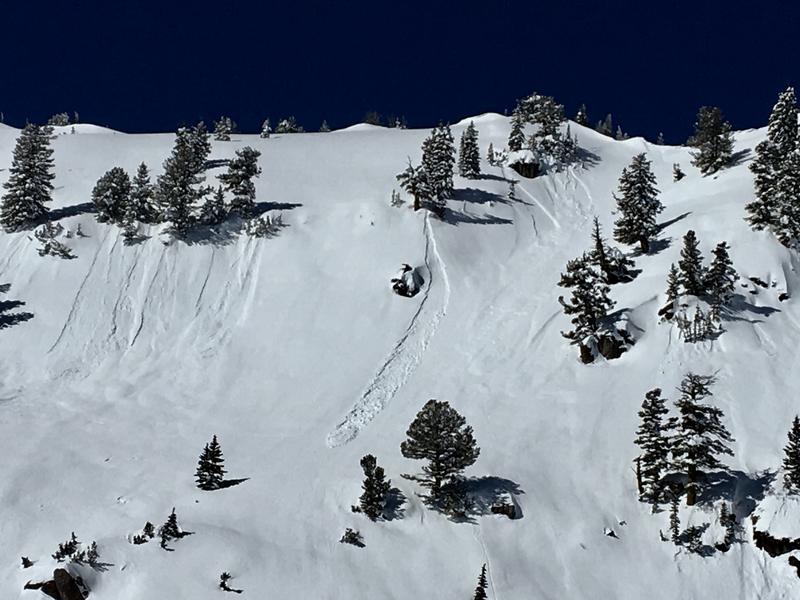
There were a few midday natural wet avalanches in the area over the weekend, but these are to be expected as the winter snow is warmed up by the strong March sun. No new avalanches were reported in the Logan Zone and it was quite busy in the backcountry.
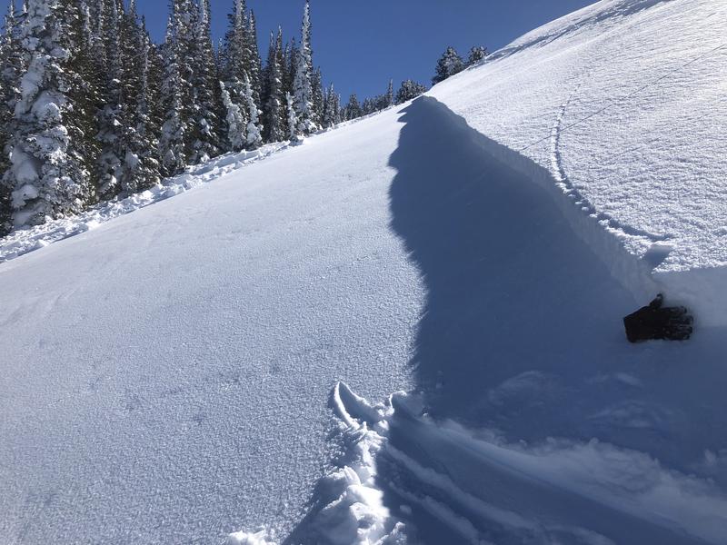
A skier remote triggered a 8" deep and 200' wide avalanche running on a persistent weak layer on a northwest facing slope at about 8800' on James Peak in the Southern Bear River Range on Saturday. Report is HERE.
This intentionally triggered shallow soft slab avalanche failed on surface hoar with energy several feet below a slope cut.
Ad
Avalanche Problem #1
Normal Caution
Type
Location
Likelihood
Size
Description
  • On isolated upper elevation slopes It may still be possible to trigger 1 or 2 foot deep soft slab avalanches failing on a buried persistent weak layer.
  • Avoid large cornices and older wind drifts on the lee side of major ridges in and around terrain features like sub-ridges, gullies, scoops, stringers, and cliff bands.
Avalanche Problem #2
Wet Snow
Type
Location
Likelihood
Size
Description
Avalanches of wet snow will become increasingly possible today as snow becomes melt-softened and saturated. Cooling breezes will be light, and the sun's radiation could be trapped by high cloud cover. You should avoid steep slopes with soft saturated or sticky surface snow. Roller balls, pin wheels, and small natural sluffs indicate potential for loose wet avalanches. You can avoid this problem by getting an early start and leaving the mountains early in the day, before the snow gets too warm.
Additional Information
I will update this forecast Wednesday morning.
The new weather station at the WSU Bloomington Canyon Yurt is up and running. Data available HERE
Now is a great time to practice companion rescue techniques with your backcountry partners. You should check out and use the new Avalanche Beacon Training Park we set up at the Franklin Basin trailhead. Special thanks to Northstars Ultimate Outdoors, USU Outdoor Program, and Beaver Mountain Ski Patrol for helping us to make this possible.
General Announcements
The Beaver Mountain Backside is the backcountry, and it is avalanche terrain. Same goes for the steep rocky terrain adjacent to Cherry Peak Resort. If you leave a ski area boundary, you and your partners should carry and practice with avalanche rescue equipment and follow safe backcountry travel protocols.
Check out the improved weather links, road conditions, and weather links for each forecast region on the new UAC IOS App. Do you use the NOAA point forecast? If so, now you can bookmark your favorite weather locations in "My Weather" in the App. HERE
Are you new to the backcountry or looking to refresh your skills? The UAC has released a free 5-part avalanche skills eLearning series. HERE
If you would like to get the daily advisory by email you subscribe HERE.
Support the UAC through your daily shopping. When you shop at Smith's, or online at REI, Backcountry.com, Patagonia, NRS, Amazon, eBay by clicking on these links, they donate a portion of your purchase to the UAC. If you sell on eBay, you can have your See our Affiliate Page for more details on how you can support the UAC when you shop
Remember your information can save lives. If you see anything we should know about, please help us out by submitting snow and avalanche observations. HERE You can call us at 801-524-5304, email by clicking HERE, or include #utavy in your Instagram.
This forecast is from the U.S.D.A. Forest Service, which is solely responsible for its content. The forecast describes general avalanche conditions and local variations always occur.