Donate to the 2024 Spring Campaign to help rebuild the UAC website.

Forecast for the Logan Area Mountains

Toby Weed
Issued by Toby Weed for
Tuesday, March 12, 2019
CONSIDERABLE: Solar heating will cause dangerous avalanche conditions on sunny slopes. Natural loose avalanches of wet snow are likely on sun-warmed slopes at all elevations. The snow is stable on most other slopes, but there are still areas with heightened avalanche conditions at mid and upper elevations. Human triggered avalanches 1 to 2 feet deep remain possible. Loose wet avalanches overrunning a steep slope could trigger a larger avalanche on a buried persistent weak layer capping last week's crust.
  • Use extra caution in sunny terrain. Evaluate snow and terrain carefully, and make conservative decisions.
Low
Moderate
Considerable
High
Extreme
Learn how to read the forecast here
Special Announcements
Enjoy spring skiing at Snowbasin Resort. The UAC has discount Snowbasin tickets available. HERE
Weather and Snow
The Tony Grove Snotel at 8400' reports 21 ºF this morning and there is 94" of total snow with 108% of average SWE for the date. It's 17 ºF at the 9700' CSI Logan Peak weather station, and southwest winds are currently averaging around 20 mph. Although the snow on most slopes is stable, heightened avalanche conditions still exist in places, and you might trigger 1 to 2 foot deep avalanches on some upper and mid elevation slopes. Solar warming could cause dangerous wet avalanche conditions on sunny slopes again today, with natural activity likely in places.

A cold pacific trough will cross the area midweek with accumulating snow to the valley floors. High pressure will build in after that bringing a more prolonged stretch of dry and mild weather. It'll be mostly sunny today, with high temperatures at 8500' expected be around 34 ºF, with 7 to 13 mph south winds. Snow will start late tonight, with 1 to 3 inches of accumulation possible. Low temperatures will be around 12º F, with 15 to 20 mph southwest winds. Snow will continue tomorrow, with 2 to 4 inches possible, high temperatures around 21 ºF, with 25 mph northwest wind, gusting to around 40 mph.
Recent Avalanches
There were numerous natural wet loose avalanches visible from Cache Valley, and by yesterday evening the mountains looked like they were dripping hot wax.

Snowmobilers triggered a couple good sized soft slab avalanches on Saturday. One on a south facing slope at around 8700' in elevation in Boss Canyon in Franklin Basin near the Idaho State Line, the other on a southeast facing slope at around 8400' in White Pine Canyon. The avalanches appear to have failed on a thin sugary or faceted persistent weak layer on top of a melt-freeze crust that was on the snow surface at the beginning of March.
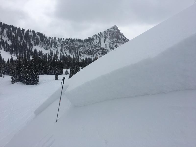
An interesting avalanche in the Ogden Backcountry adjacent to Snowbasin from yesterday 3/11/19. Looks like a wet avalanche triggered a soft slab as it overran a steep slope, and the avalanche took out a bunch of recent tracks.

A sled triggered soft slab avalanche from Saturday (3/9/19) in White Pine Canyon.
Ad
Avalanche Problem #1
Wet Snow
Type
Location
Likelihood
Size
Description
There was a good deal of natural wet loose activity yesterday, and the mountains look like they are dripping melted candle wax. Solar warming will again cause the surface snow on sunny slopes to become damp and sticky or even saturated and slushy. Loose wet avalanches will become increasingly likely on slopes that are exposed to direct sun. If the snow you're on starts to get sticky or wet, you should leave and head somewhere else.
Avalanche Problem #2
Persistent Weak Layer
Type
Location
Likelihood
Size
Description
Avalanches could fail on a persistent weak layer that was buried by last week's storm. This weekend's avalanches failed on sugary or faceted snow grains atop a melt-freeze crust, perhaps what we call radiation recrystallization... The storm also may have preserved surface hoar that was fairly widespread on the snow surface at upper elevations. These kinds of weaknesses usually heal pretty quickly this time of year, but we have to consider the possibility of the instability lingering in places.
Additional Information
I will update this forecast Wednesday morning.
The new weather station at the WSU Bloomington Canyon Yurt is up and running. Data available HERE
Now is a great time to practice companion rescue techniques with your backcountry partners. You should check out and use the new Avalanche Beacon Training Park we set up at the Franklin Basin trailhead. Special thanks to Northstars Ultimate Outdoors, USU Outdoor Program, and Beaver Mountain Ski Patrol for helping us to make this possible.
General Announcements
The Beaver Mountain Backside is the backcountry, and it is avalanche terrain. Same goes for the steep rocky terrain adjacent to Cherry Peak Resort. If you leave a ski area boundary, you and your partners should carry and practice with avalanche rescue equipment and follow safe backcountry travel protocols.
Check out the improved weather links, road conditions, and weather links for each forecast region on the new UAC IOS App. Do you use the NOAA point forecast? If so, now you can bookmark your favorite weather locations in "My Weather" in the App. HERE
Are you new to the backcountry or looking to refresh your skills? The UAC has released a free 5-part avalanche skills eLearning series. HERE
If you would like to get the daily advisory by email you subscribe HERE.
Support the UAC through your daily shopping. When you shop at Smith's, or online at REI, Backcountry.com, Patagonia, NRS, Amazon, eBay by clicking on these links, they donate a portion of your purchase to the UAC. If you sell on eBay, you can have your See our Affiliate Page for more details on how you can support the UAC when you shop
Remember your information can save lives. If you see anything we should know about, please help us out by submitting snow and avalanche observations. HERE You can call us at 801-524-5304, email by clicking HERE, or include #utavy in your Instagram.
This forecast is from the U.S.D.A. Forest Service, which is solely responsible for its content. The forecast describes general avalanche conditions and local variations always occur.