Sign Up for the Utah Snow and Avalanche Workshop (USAW) on December 7th!

Forecast for the Logan Area Mountains

Toby Weed
Issued by Toby Weed on
Thursday morning, February 4, 2021
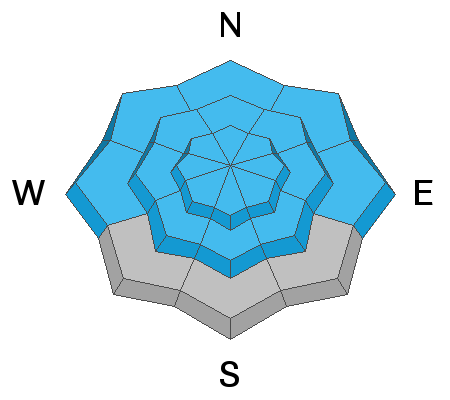
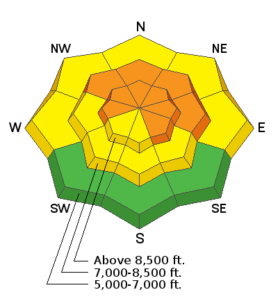
Dangerous avalanche conditions and CONSIDERABLE danger exist on many drifted upper and mid elevation slopes. People are likely to trigger dangerous avalanches if they venture into steep drifted terrain. Avalanches of wind drifted snow are possible at all elevations and most likely on slopes facing northwest, north, northeast and east. Devious buried persistent weak layers consisting of sugary faceted snow are widespread across the Logan Zone, and the serious threat of deadly avalanches is quite real.
Heavy snow and drifting from a winter storm will cause rising avalanche danger in the backcountry tonight and tomorrow.
  • Evaluate snow and terrain carefully, and make conservative decisions.
  • Stay off and out from under drifted slopes steeper than about 30 degrees.
Low
Moderate
Considerable
High
Extreme
Learn how to read the forecast here
Weather and Snow
About 6 inches of new snow fell yesterday and 1 or 2 more early this morning on upper elevation slopes. West-northwest winds are blowing around 20 mph, and I'm reading 9°F, with a -10°F wind chill value at the 9700' CSI Logan Peak weather station. Dangerous avalanche conditions exist on drifted slopes in the backcountry, and human triggered avalanche are likely.
Today will be mostly cloudy with snow showers in the afternoon, 8500' high temperatures around 17°F, and wind chill values around -5°F. Snow is likely tonight, with increasing westerly winds and 3 to 5 inches of accumulation possible. Expect rising avalanche danger overnight and tomorrow, with 7 to 11 inches of accumulation forecast for upper elevation slopes tomorrow and drifting from fairly strong west-southwest winds.

On Monday we went up to the Naomi Peak Area to check out a large natural avalanche in Castle Rock that looks like it ran early Saturday before anybody could get up in the area. Here is our video....
Recent Avalanches
Tragically, a skier was killed in an avalanche on Square Top in the backcountry above Park City on Saturday. Accident Report

Locally: A party of riders remote triggered a couple large avalanches in the Logan Peak Area Tuesday, (2-2-2021). One, running into Mill Hollow was 7 or 8 feet deep and pulled out all the season's snow to the ground.

  • Sunday (1-31-2021), There was a close call near Steam Mill Lake. Details are limited, but a snowmobiler triggered a large avalanche and apparently escaped harm.
  • Saturday (1-30-2021), Riders triggered a good sized avalanche on the east face of Doubletop Mountain (or Gun Sight). Nobody was caught, but another sizable avalanche sympathetically released, and both avalanches crossed the party's previous tracks on the slope.
  • There were numerous avalanches locally and across the Utah mountains in the past few days. Visit our avalanche list HERE.
Ad
Avalanche Problem #1
Persistent Weak Layer
Type
Location
Likelihood
Size
Description
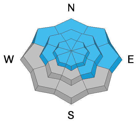
Heavy snow tonight and tomorrow will add weight to slopes that may already be near the tipping point... Very weak sugary or faceted snow is widespread across the region, and people are likely to trigger avalanches where a slab of more cohesive snow has formed on top of the weak snow. Natural avalanches will become increasingly likely tomorrow, especially during periods of rapid accumulation, as heavy snow overloads slopes with poor snow structure or unstable snow.
  • Avalanches failing on a buried persistent weak layer might be triggered remotely, from a distance, or worse from below!
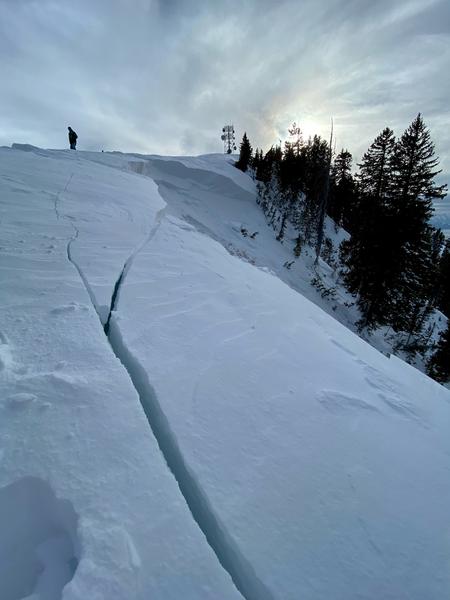
  • Cracking and collapsing of the snow are a red flag, indicating unstable snow conditions.
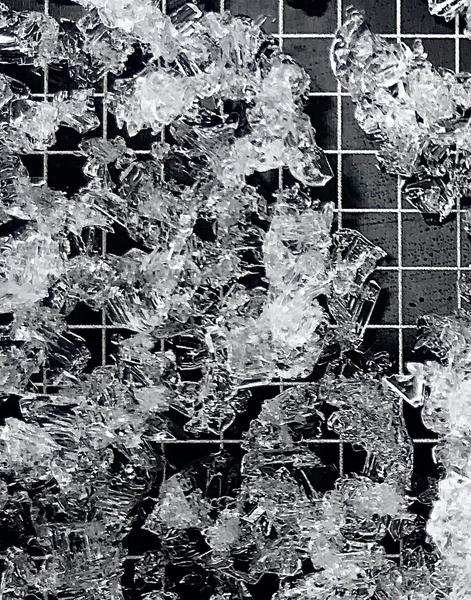
These large faceted snow grains make up a nasty buried persistent weak layer that is widespread in the Logan Zone. It exists on slopes at all elevations across the zone. (Stump Hollow, 1-30-2021)
Avalanche Problem #2
Wind Drifted Snow
Type
Location
Likelihood
Size
Description
Westerly winds yesterday and overnight drifted fresh snow into lee slope avalanche starting zones, and built drifts and wind slabs on steep slopes at upper and mid elevations. Recent drifting has created thick cohesive slabs and people are likely trigger avalanches of wind drifted snow, especially where drifts have built on top of a buried persistent weak layer.
  • Wind slabs are often rounded and chalky looking drifts, and they can sound and feel hollow and drum-like when you walk on them.
  • Watch for and avoid stiffer drifted snow near ridge tops and in and around terrain features like gullies, scoops, cliff bands, and sub ridges.
Additional Information
Do you have the essential avalanche rescue gear (transceiver, probe, and shovel) and do you know how to use them? Watch this video to see how the three pieces of equipment work together. HERE
Please keep practicing with the Beacon Training Park at the Franklin Basin Trailhead. Test yourself and your riding partners. It is free, fun, and easy to use.
General Announcements
Thanks to the generous support of our local resorts, Ski Utah, and Backcountry, discount lift tickets are now available. Support the UAC while you ski at the resorts this season. Tickets are available here.
Visit this website with information about Responsible Winter Recreation by the Utah Office of Outdoor Recreation.
EMAIL ADVISORY. If you would like to get the daily advisory by email you subscribe HERE.
Remember your information can save lives. If you see anything we should know about, please help us out by submitting snow and avalanche observations....HERE. You can also call us at 801-524-5304, email by clicking HERE, or include #utavy in your tweet or Instagram.
I will update this forecast by around 7:30 tomorrow morning.
This forecast is from the USDA Forest Service, which is solely responsible for its content. The forecast describes general avalanche conditions and local variations always occur.