Forecast for the Logan Area Mountains

Toby Weed
Issued by Toby Weed for
Tuesday, February 28, 2023
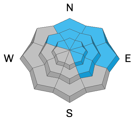
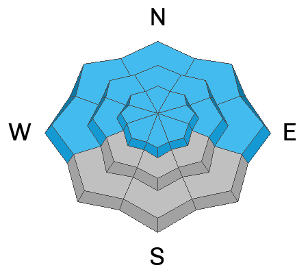
There is HIGH avalanche danger in the backcountry. Dangerous conditions exist on drifted slopes at all elevations, and periods of heavy snowfall and drifting from strong westerly winds will continue to elevate avalanche danger. People are likely to trigger dangerous avalanches today, and long running natural avalanches are also likely.
  • Avoid travel in avalanche terrain, and stay clear of avalanche runouts. Stay off and out from under backcountry slopes steeper than 30°
Low
Moderate
Considerable
High
Extreme
Learn how to read the forecast here
Special Announcements
Come out and ride for a cause! Utah Snowmobile Association's 6th annual RALLY IN THE VALLEY is being held March 4th at the cabins at Bear River Lodge. Bring family and friends to join in the fun! All of the proceeds from RALLY IN THE VALLEY go directly to supporting the sport in our state.
Weather and Snow
The National Weather Service has continued a Winter Storm Warning for the Logan Zone through Wednesday. The storm is exceeding expectations, and heavy snowfall and drifting by west winds will continue to elevate the avalanche danger, especially on drifted slopes. Avalanches are also likely today in lower elevation areas where slabs of wind drifted snow are getting thicker and heavier on slopes with poor snow structure.
I plan to avoid avalanche terrain today, which means I'll stay off and out from under backcountry slopes at all elevations steeper than 30°.

The 8400' Tony Grove Snotel reports around 27 inches of heavy new snow, with 3.1" SWE, from the storm so far. It's 16° F this morning, and there is 131 inches of total snow. The wind is blowing from the west-northwest 25 to 30 mph and gusting well into the 60s at the 9700' CSI Logan Peak weather station.
Here is the NWS point forecast for high elevations in the Central Bear River Range:
Today: Snow, mainly before 3pm. The snow could be heavy at times. High near 16. Wind chill values as low as -6. Windy, with a west southwest wind 24 to 33 mph. Chance of precipitation is 80%. Total daytime snow accumulation of 5 to 9 inches possible.
Tonight: Snow likely, mainly after midnight. The snow could be heavy at times. Mostly cloudy, with a temperature rising to around 17 by 3am. Wind chill values as low as -9. Breezy, with a south wind 20 to 26 mph, with gusts as high as 36 mph. Chance of precipitation is 70%. New snow accumulation of 6 to 10 inches possible.
Wednesday: Snow. High near 24. Wind chill values as low as -1. South wind 11 to 17 mph becoming east in the afternoon. Chance of precipitation is 80%. New snow accumulation of 2 to 4 inches possible.

A break in the stormy weather is expected late Wednesday and Thursday, with a return to unsettled weather through next weekend.
Recent Avalanches
  • A natural avalanche yesterday morning ran ~1250 vrt' to Green Canyon bottom less than 100' from access road to popular trailhead at about 5000' in elevation,
  • skiers report triggering a few 18" deep soft slab avalanches on Beaver Backside...8700', southeast facing slope,
  • widespread booming collapses and remotely triggered cornice falls were reported from Blind Hollow.
  • Saturday, a group of sledders reports remotely triggering three wind slab avalanches in the Castle Rock area, just south of Naomi Peak, and skiers remotely and intentionally triggered cornice fall and small soft wind slab avalanches in terrain above the Forestry Research Center in Logan Canyon

    For a list of avalanches in the Logan Zone go HERE
    Find a list of all recent observations & avalanches from across Utah HERE.
Ad
Avalanche Problem #1
Wind Drifted Snow
Type
Location
Likelihood
Size
Description
This morning winds are blowing from the west, and they've been way more than strong enough to drift the heavy powder from yesterday and overnight. Avalanches of wind drifted storm snow, 2 to 3 feet thick, are likely on drifted slopes at all elevations, but will be larger and even more likely for people to trigger on upper elevation slopes facing northwest through southeast.
  • Avoid corniced slopes and stiffer drifts on steep slopes near ridges and in and around terrain features like cliff bands, sub-ridges, mid-slope break-overs, and gully walls.
  • Wind slabs consist of stiffer drifted snow. Today, soft avalanches of drifted storm snow are likely.
  • Some wind slab avalanches could fail on a sugary persistent weak layer, and some might be triggered remotely.
  • Stay well clear of the freshly swollen cornices, which are likely to break further back than you might expect and could trigger wind slab avalanches below.
  • Natural avalanches are possible, especially during periods of intense drifting.
Avalanche Problem #2
Persistent Weak Layer
Type
Location
Likelihood
Size
Description
The PWL problem is widely scattered across terrain, especially at mid and upper elevations, where thin layers of sugary snow or other weak snow grains exist in pockets, but on most aspects. At lower elevations in the Logan Zone layers of sugary faceted snow are more widespread and more prevalent on northerly facing slopes. There were many lower elevation areas with very weak faceted snow before last week's storm capped and moistened it with rain and heavy snow. The snow was particularly weak in protected lower elevation terrain, and poor snow structure and areas with unstable old snow can be found now on lots of lower elevation slopes.
  • Avalanches failing on a persistent weak layer are possible at all elevations but are notably also possible down lower, below about 7000' elevation.
  • Avalanches could be triggered remotely or from a distance.
Watch Drew's video about similar lower elevation conditions in the foothills above Salt Lake City:
Avalanche Problem #3
New Snow
Type
Location
Likelihood
Size
Description
Over two feet of heavy snow fell already with this storm and another foot of accumulation is possible in the Bear River Range today. As heavy snow stacks up on steep slopes it will be pretty unstable in some areas.
People are likely to trigger soft slab and loose avalanches of storm snow on slopes steeper than 30°. Natural avalanches are increasingly likely.
  • Natural avalanches are most likely during periods of particularly heavy snowfall and/or drifting.
Additional Information
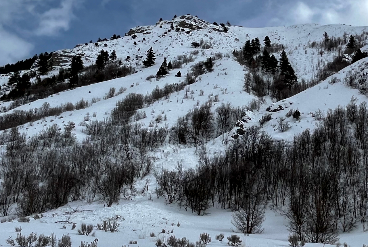
A natural avalanche Monday morning in lower Green Canyon ran over a thousand verticle feet and came pretty close to the road accessing the popular trailhead. This is the second one in the area this week and more are possible, so heads up!
General Announcements
  • Please submit your observations from the backcountry HERE.
  • For a list of avalanche classes from the Utah Avalanche Center go HERE
  • For information on where you can ride your sled or snowbike, check out this map of the winter travel plan for the Logan and Ogden Ranger Districts HERE, and a close up of the Tony Grove and Franklin Basin Areas HERE.
This forecast is from the U.S.D.A. Forest Service, which is solely responsible for its content. This forecast describes general avalanche conditions and local variations always occur.