Join us at our 2nd Annual Blizzard Ball

Forecast for the Logan Area Mountains

Toby Weed
Issued by Toby Weed on
Sunday morning, February 28, 2021
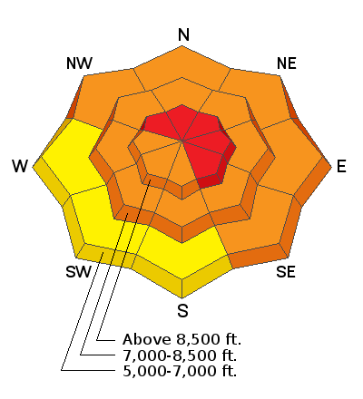
There is CONSIDERABLE avalanche danger on many steep slopes. Conditions in the backcountry are dangerous due to deep accumulations of new snow and drifting from westerly winds. Avalanches are likely across the Logan Zone, but the danger is higher to the north, and areas with HIGH danger exist on drifted upper elevation slopes facing northwest through southeast. People will likely trigger large avalanches failing 3 to 4 feet deep on a widespread buried persistent weak layer if they venture into steep terrain, and natural avalanches are possible. Large and dangerous avalanches might be triggered remotely, from a distance, or below.
  • Expect unstable snow conditions, even if obvious signs of instability are absent.
  • Choose safe routes in low angled terrain well out from under and not connected to drifted slopes steeper than about 30 degrees.
Low
Moderate
Considerable
High
Extreme
Learn how to read the forecast here
Weather and Snow
Looks like about 2 feet of new snow, with 2.3" Snow Water Equivalent with this weekend's storm at the 8400' Tony Grove Snotel. It's 9°F, and there is 86 inches of total snow and 84% of normal SWE. Winds from the northwest are blowing 15 mph at the CSI Logan Peak weather station. There has been a good deal of drifting of the new snow, especially at upper elevations from mostly westerly winds during the storm. Winds during periods of heavy snowfall can cause significant loading of Utah powder across large lee slope deposition areas.
We're expecting mostly sunny conditions in the mountains, and continuing fair weather and gradual warming through the upcoming week. Temperatures at 8500' will top out at around 18°F, and the 15 mph west winds will and create wind chill values as low as -12°F.
Recent Avalanches
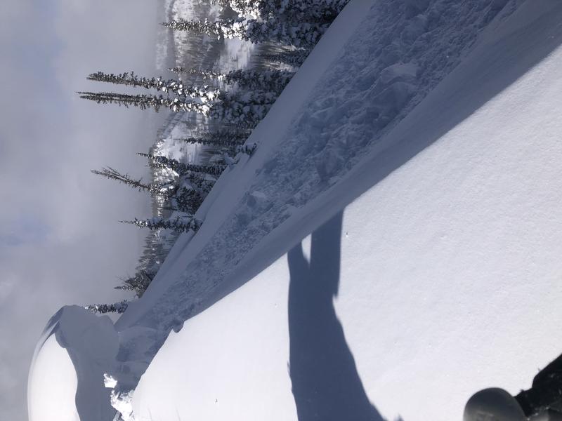
From a safe distance, a party of backcountry skiers found sensitive and building cornices on the ridge near Steam Mill Peak.

Last Saturday, 2-20-2021, a 48-year-old Preston man was killed in an avalanche on the east side of Sherman Peak west of Georgetown Idaho. Our preliminary accident report is HERE.
Ad
Avalanche Problem #1
Persistent Weak Layer
Type
Location
Likelihood
Size
Description
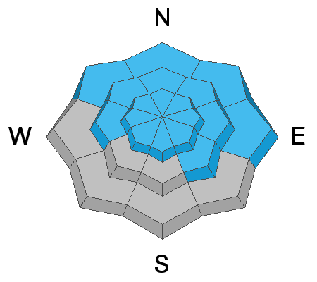
Most natural avalanches in the Logan Zone occur during significant winter storms, but most accidents seem to happen when the weather clears, right after the storms. Heavy snowfall and westerly winds during the storm added weight to, and probably overloaded slopes with poor snow structure that were already near the tipping point. Buried persistent weak layers consisting of sugary faceted snow are widespread across the Logan Zone, and the threat of large and deadly avalanches failing on weak snow near the ground is quite real again this weekend.
  • Avalanches failing on a buried persistent weak layer might be triggered remotely, from a distance, or worse from below!
  • Cracking and collapsing of the snow are a red flag, indicating unstable snow conditions.
Avalanche Problem #2
Wind Drifted Snow
Type
Location
Likelihood
Size
Description
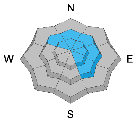
Drifting occurred and avalanches of wind drifted snow are possible at all elevations and on slopes facing every direction, but most likely on upper and mid elevation slopes facing northwest through southeast. Avalanches of wind drifted snow are likely where fresh drifts formed on steep slopes, especially on slopes with buried persistent weak layers. Cornices are large and were reported to be quite sensitive as they continued to grow yesterday. You should continue to avoid travel on and below all steep drifted slopes today.
  • Wind slabs are often rounded and chalky looking, and they can sound and feel hollow and drum-like when you walk on them.
  • Watch for and avoid stiffer drifted snow near ridge tops and in and around terrain features like gullies, scoops, cliff bands, and sub ridges.
  • Stay well back from cornice edges as they can break much further back than you expect and avalanches are likely on slopes below.
Avalanche Problem #3
New Snow
Type
Location
Likelihood
Size
Description
Loose avalanches and soft slabs of storm snow remain likely today on steep slopes, even in sheltered terrain. Even a small avalanche could be enough to cause problems, especially on steep slopes with trees or other terrain traps below. Smaller avalanches overrunning a slope with buried persistent weak layers could step down into older snow near the ground and cause a much larger and more destructive avalanche.
Additional Information
Do you have the essential avalanche rescue gear (transceiver, probe, and shovel) and do you know how to use them? Watch this video to see how the three pieces of equipment work together. HERE
Please keep practicing with the Beacon Training Park at the Franklin Basin Trailhead. Test yourself and your riding partners. It is free, fun, and easy to use.
General Announcements
Visit this website with information about Responsible Winter Recreation by the Utah Office of Outdoor Recreation.
EMAIL ADVISORY. If you would like to get the daily advisory by email you subscribe HERE.
Remember your information can save lives. If you see anything we should know about, please help us out by submitting snow and avalanche observations....HERE. You can also call us at 801-524-5304, email by clicking HERE, or include #utavy in your tweet or Instagram.
I will update this forecast by around 7:30 tomorrow morning.
This forecast is from the USDA Forest Service, which is solely responsible for its content. The forecast describes general avalanche conditions and local variations always occur.