Join us for the 17th Annual Professional Snow and Avalanche Workshop (PROSAW) on November 4 - Purchase tickets here!

Forecast for the Logan Area Mountains

Toby Weed
Issued by Toby Weed on
Saturday morning, February 24, 2024
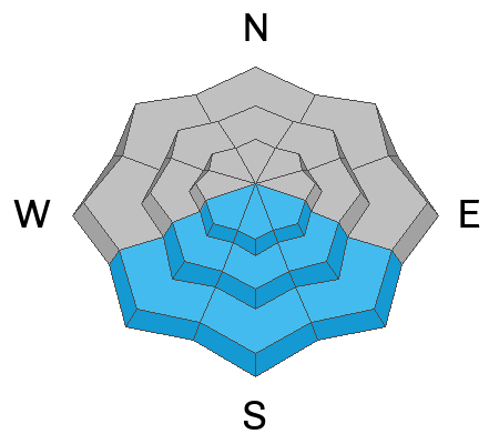
You'll find nice powder riding conditions in northerly facing terrain, but elevated avalanche conditions exist, and human-triggered avalanches are possible in the backcountry. The danger is MODERATE on slopes steeper than 30° at all elevations.
  • On upper and mid-elevation east, south, and west-facing slopes, people could trigger large avalanches failing around 2 feet deep on a thin, persistent weak layer above a melt-freeze crust.
  • Avalanches of wind-drifted snow and cornice falls are possible in high mountain terrain.
  • Wet avalanches, entraining heavy piles of moist surface snow, will become possible on sunny slopes at all elevations in the midday heat.
  • Safer conditions, stable snow, and generally LOW danger can be found on lower angled slopes and in most northerly facing sheltered terrain.

Evaluate snow and terrain carefully, especially on drifted slopes with a solid melt-freeze crust buried 2 to 3 feet deep. Avoid being on or under steep, sunny slopes with saturated new snow.
Low
Moderate
Considerable
High
Extreme
Learn how to read the forecast here
Special Announcements
We are seeking a passionate individual to join us as Executive Director of the nonprofit Utah Avalanche Center. Click here for more information.
Weather and Snow
This weekend, nice settled powder conditions can be found in northerly-facing terrain. However, warm temperatures and the powerful late February sun have affected the snow in the meadows and on most slopes, so we'll find crusty conditions in the morning and moist or slushy surface snow later in the day.

The Tony Grove Snotel at 8400' reports 21° F this morning, with 106" of total snow containing around 120% of normal SWE (snow water equivalent). The wind is blowing from the west this morning around 24 mph at the 9700' CSI Logan Peak weather station. At 9500' on Paris Peak, winds are blowing from the southwest around 25 mph, and it's 17° F.

Today will be sunny in the mountains. The winds will blow from the west 13 to 18 mph. High temperatures at 8500' are expected to be around 34° F, but will rise to around 42° F down lower in Logan Canyon. Tonight will be mostly clear, with mountain temperatures falling into the teens. Tomorrow will be sunny with high temperatures up high around 36° F and around 45° F in Logan Canyon. It will be breezy, with 21 to 25 mph winds blowing from the west-southwest.
The National Weather Service has issued a Winter Storm Watch for the Logan Zone beginning Sunday night and lasting through Tuesday, with significant snow accumulations likely, especially on upper elevation slopes.
Recent Avalanches
  • Wednesday afternoon, a rider remotely triggered a 2-foot-deep slab avalanche in upper Providence Canyon. The avalanche on a south or southeast-facing slope at around 8300' in elevation probably failed on a thin persistent weak layer. see report
  • Evidence of several broad natural slab avalanches was observed with yesterday's clearing in both the Wellsville Mt Wilderness and the Mt Naomi Wilderness. I saw evidence of a few natural SS avalanches in Rattlesnake Canyon that ran off Mitton Peak on east-facing slopes between 7000 and 7800'. Several others on the western slopes above Hyde Park, Smithfield, and Richmond were observed (glassed) from a distance from across Cache Valley. It's hard to estimate sizes, but I'd guess the largest to be around 2' deep and up to about 500' wide. See report
  • We also received a third-person report with no details of a snowmobiler-triggered avalanche on Thursday in Boss Canyon near the state line in the Franklin Basin Area... East facing at around 9000' in elevation.

Check out all local observations and avalanches HERE.
Ad
Avalanche Problem #1
Persistent Weak Layer
Type
Location
Likelihood
Size
Description
In some outlying upper and mid-elevation terrain on slopes generally facing the southern half of the compass (east through south through west), human-triggered avalanches could fail on a sugary, persistent weak layer on top of a melt-freeze crust buried 2 to 3 feet deep. This thin, persistent weak layer was buried and overloaded by the productive storms over the past 10 days. The problem is more pronounced in sunny terrain where the thin layer of faceted snow sits atop a supportable melt-freeze crust.
  • Avalanches might be triggered remotely, from a distance or below.
  • Audible collapses or whumpfs and shooting cracks are obvious signs of instability, but these red flags may not be present when avalanches occur.
Avalanche Problem #2
Wind Drifted Snow
Type
Location
Likelihood
Size
Description
Human-triggered avalanches of wind-drifted snow and cornice falls are possible in drifted upper-elevation terrain today. This morning, strengthening winds are blowing from the west and southwest. On Paris Peak this morning, the wind is blowing 25 mph from the southwest. (These are significantly stronger winds than we've seen up there all week.)
  • Watch for and avoid fresh wind drifts on the lee side of major ridges, corniced slopes, and in and around terrain features like cliff bands, sub-ridges, gully walls, and mid-slope rollovers.
  • Stay well away from and out from under overhanging cornices, which may break further back than expected.
Avalanche Problem #3
Wet Snow
Type
Location
Likelihood
Size
Description
With sunny skies and way above-freezing temperatures in today's forecast, wet avalanches entraining saturated surface snow will become possible in sunny terrain in the heat of the day.
  • Roller balls, pinwheels and natural sluffs or loose avalanches are signs of instability.
  • Avoid being on or under steep sunny slopes with saturated new snow.
Additional Information
A natural avalanche in the Mt Naomi Wilderness was observed from a distance on Friday afternoon. This likely failed on a thin, sugary, persistent weak layer.
General Announcements
-Listen to your very own Logan Zone avalanche forecasters on the UAC Podcast HERE.
-Read my recent blog about wind, drifting, and avalanches HERE.
-Sign up for forecast region-specific text message alerts. You will receive messages about changing avalanche conditions, watches, and warnings...HERE.
-For all questions on forecasts, education, Know Before You Go, events, online purchases, or fundraising, call 801-365-5522.
-To report an avalanche or submit an observation from the backcountry, go HERE.
-Come practice companion rescue at the Franklin Basin TH Beacon Training Park. It's free and open to everyone. For easy user instructions, go HERE.
-We will update this forecast by 7:30 AM tomorrow.
This forecast is from the U.S.D.A. Forest Service, which is solely responsible for its content. This forecast describes general avalanche conditions, and local variations always occur.