31st Annual Backcountry Benefit - September 12th - Tickets Available Here!

Forecast for the Logan Area Mountains

Toby Weed
Issued by Toby Weed on
Sunday morning, February 11, 2024
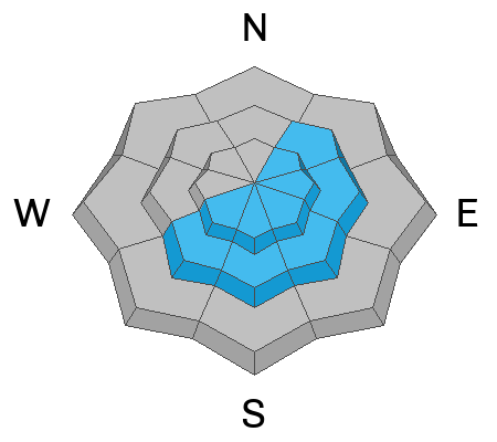
The danger is MODERATE; Elevated avalanche conditions exist on upper and mid-elevation slopes steeper than 30°. People could trigger slab avalanches of wind-drifted snow, and cornice falls are possible in some drifted terrain. The probability of triggering a dangerous avalanche failing on a buried persistent weak layer is low, but not zero. These remain possible in outlying drifted rocky terrain with shallow snow cover.
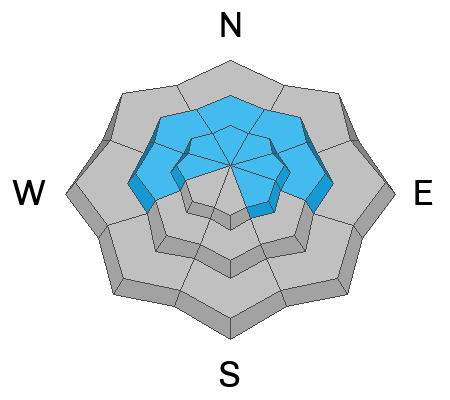
The danger is LOW, and avalanches are unlikely at low elevations and on most sheltered slopes.

Fine, fast, shallow powder conditions are easy to find on slopes less steep than 30° across the Logan Zone. Evaluate snow and terrain carefully, and don't let the nice powder cloud your judgment.
Low
Moderate
Considerable
High
Extreme
Learn how to read the forecast here
Special Announcements
Want to learn more about how to stay safe from avalanches while riding in the backcountry? Join us Feb 23-24 for an Introduction to Avalanche class. Information and registration here.
Weather and Snow
Fine, fast, and fun powder conditions are found in many areas. Safe lower-angled slopes (less steep than 30°) offer a good option and some of the best riding due to a solid crust formed during last week's warm spell.
The backcountry avalanche danger is not as high as in areas to our south because we received much less new snow last week, cold temperatures have hardened a thick melt-freeze crust beneath the fresh snow, and the deeper heavy snow from January makes the snowpack generally more stable.

The wind is blowing from the north this morning 20 mph at 9500' on Paris Peak, and it's a chilly 7° F. The Tony Grove Snotel at 8400' reports 8° F and 83 inches of total snow, containing 120% of average SWE (Snow Water Equivalent). It's also 8° F at the 8750' Card Canyon weather station and there is 68" of total snow at the site.

Skies will be sunny in the mountains today, with a high temperature around 25° F at 8500'. The wind will blow from the northwest 6 to 8 mph. Tomorrow expect increasing clouds, with high temperatures around 26° F and increasing winds blowing 10 to 17 mph from the west-southwest. There is a chance of snow on Tuesday, but accumulations will not add up to much, with less than an inch expected in the mountains.
Recent Avalanches
A skier triggered a small avalanche of loose snow, sliding on a slick crust in the Beaver Mountain Backcountry on Friday. No more significant avalanches have recently been reported in the Logan Zone. However, there were a few large and scary avalanches failing on a deeply buried persistent weak layer on Saturday in the Wasatch Range. See the reports HERE
Check out local observations and avalanches HERE.
Ad
Avalanche Problem #1
Wind Drifted Snow
Type
Location
Likelihood
Size
Description
Winds blowing from the north increased overnight, especially at the new Paris Peak weather station. The winds were plenty strong enough to drift the light snow in exposed upper-elevation terrain and likely created wind slabs on the lee side of major ridges and in and around terrain features like sub ridges, gully walls, mid-slope roll-overs, and under cliff bands.
  • Avoid recent drifts and stiffer wind slabs on steep slopes.
  • Human-triggered avalanches of wind-drifted snow are possible at upper and mid elevations and most likely on upper-elevation slopes facing northeast through southwest.
  • Stay well away from and out from under overhanging cornices, which may break further back than expected.
Avalanche Problem #2
Persistent Weak Layer
Type
Location
Likelihood
Size
Description
Large and scary avalanches failing on sugary snow near the ground are unlikely but not impossible. In some outlying areas with shallower snow cover (3 or 4 feet deep), a buried persistent weak layer of faceted snow from the December dry spell may be reawakened by this week's incremental load of new snow. The probability is low, but not zero, and potential hard slab avalanches could be large, destructive, and life-threatening.
  • Avalanches failing on a persistent weak layer may be possible in recently drifted outlying rocky or windswept areas with generally shallow snow cover.
  • Collapsing or whumpfs are obvious signs of instability, but these red flags may not be present when deep hard slab avalanches failing on a persistent weak layer occur.
  • It's a good idea to dig into the snow to identify areas with poor snow structure before you commit to steeper objectives. Another trick is to probe for areas with shallower total snow that may harbor buried persistent weak layers.
Additional Information
General Announcements
-Listen to your very own Logan Zone avalanche forecasters on UAC Podcasts HERE
-Read Toby's recent blog about wind, drifting, and avalanches HERE
-Sign up for forecast region-specific text message alerts. You will receive messages about changing avalanche conditions, watches, and warnings...HERE.
-For all questions on forecasts, education, Know Before You Go, events, online purchases, or fundraising, call 801-365-5522.
-To report an avalanche or submit an observation from the backcountry, go HERE.
-Come practice companion rescue at the Franklin Basin TH Beacon Training Park. It's free and open to everyone. For easy user instructions, go HERE
-We will update this forecast by 7:30 AM tomorrow.
This forecast is from the U.S.D.A. Forest Service, which is solely responsible for its content. This forecast describes general avalanche conditions, and local variations always occur.