Forecast for the Logan Area Mountains

Issued by Toby Weed on
Monday morning, February 10, 2020
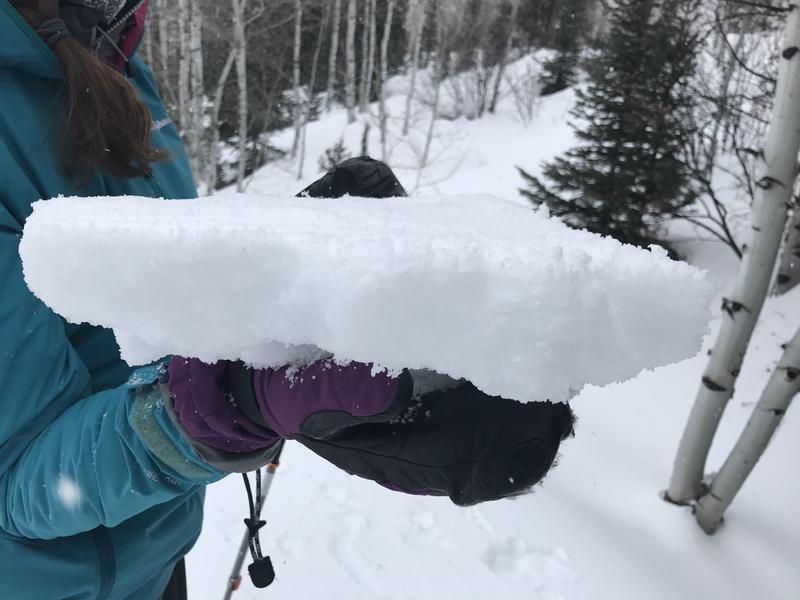
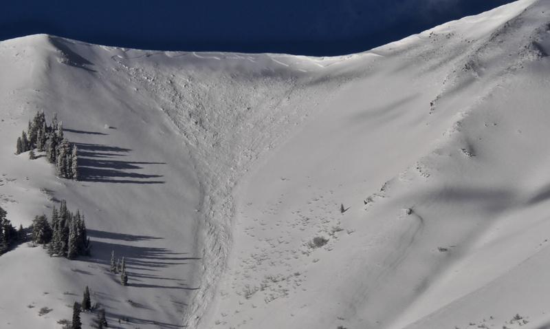
Heightened avalanche conditions and MODERATE danger exist on some previously drifted upper elevation slopes in the backcountry today. People might trigger 1 to 3 foot deep avalanches of old wind drifted snow, failing on a gradually strengthening persistent weak layer. A widespread rain-crust from Friday is helping snow stability, and the danger is LOW on most slopes in the Logan Zone.
- Use normal caution, and evaluate upper elevation snow and terrain carefully.

Low
Moderate
Considerable
High
Extreme
Learn how to read the forecast here
Weather and Snow
It's 13°F at the 8400' Tony Grove Snotel, and there is now 87 inches of total snow, containing 136% of normal Snow Water Equivalent. The station recorded almost 5"of SWE with the windy and warm late week storm. Northwest winds are currently blowing around 20 mph at the CSI Logan Peak weather station, and it's 7°F at 9700'.
Much cooler temperatures last night have set up the mushy and wet snow at lower elevations, and the snow is now harder and much more stable. A widespread thick rain-crust, translucent and brittle in places, exists in most areas in the zone even at high elevations. It is capping a soft and moist layer of graupel and heavily rimed snow. A fast moving squall dropped another inch or two of graupel and heavy snow on the crust in the Central Bear River Range Saturday.

A thick and supportable rain-crust caps Thursday's moist layer of fresh graupel and rimed snow.
There's a chance of snow showers today, and expect partly sunny conditions, with high temperatures at 8500' around 21°F, and 14 to 16 mph northwest winds. Tonight will be partly cloudy, with low temperatures around 1°F, north wind 13 to 17 mph veering from the east, and wind chill values as low as -20°F! It'll be sunny tomorrow, with a high temperature near 21°F, 8 to 16 mph northeast winds veering from the west, and wind chill values as low as -14°F.
Recent Avalanches
Clearing Saturday morning allowed us to get views of fairly widespread natural avalanche activity in the Wellsville Mountain Wilderness, including this nice fresh avalanche of wind drifted snow in Old Logway Canyon. The avalanche appears to be two to three feet deep and 300' to 400' wide, running well over 2000 vrt', but stopping just short of the flats on Maple Bench.

Natural wet avalanches hit highway 89 in the Dugway Area of Logan Canyon and forced it's closure around 3:00 Friday afternoon. The highway was closed for a couple hours so crews could clear the debris.

Avalanche Problem #1
Persistent Weak Layer
Type

Location

Likelihood

Size

Description
Heightened avalanche conditions exist on upper elevation slopes today, and people could trigger avalanches of previously wind drifted snow failing on a sugary persistent weak layer from last week. Sustained and strong west winds Thursday and Friday moved tons of heavy snow into deep drifts on the lee sides of the major ridges and avalanche starting zones. The fresh drifts were quite sensitive when they first formed, and people easily and remote triggered soft slab avalanches. Natural avalanches occurred on many drifted slopes Thursday night and Friday. The drifts gained significant stability over the weekend, and will be fairly hard and stubborn today. Hard wind drifts sometimes allow people to get out on them before releasing, kind of like a mouse trap.
- Watch for and avoid old drifts near ridge lines and in and around terrain features like cliff bands, scoops, gully walls, and sub-ridges.
- Avoid ridge top cornices, which can break much further back than expected and start avalanches on slopes below.
General Announcements
Are you looking to improve your avalanche skills? We are offering a Backcountry 101: Introduction to Avalanches class at Powder Mountain February 14-15. Info and sign up HERE
Thanks to the generous support of our Utah ski resorts and Ski Utah, we have discount lift tickets available. All proceeds from these go towards paying for avalanche forecasting and education! Get your tickets HERE.
EMAIL ADVISORY. If you would like to get the daily advisory by email you subscribe HERE.
Remember your information can save lives. If you see anything we should know about, please help us out by submitting snow and avalanche observations....HERE. You can also call us at 801-524-5304, email by clicking HERE, or include #utavy in your tweet or Instagram.
This forecast is from the USDA Forest Service, which is solely responsible for its content. The forecast describes general avalanche conditions and local variations always occur.
I will update this forecast before about 7:30 tomorrow morning.